KeviShader

11.1K posts

KeviShader banner
KeviShader

KeviShader

@KeviShader

Providing information on tropical cyclones and severe weather events.

Main Development Region เข้าร่วม Mart 2012
354 กำลังติดตาม3.2K ผู้ติดตาม
KeviShader
KeviShader@KeviShader·
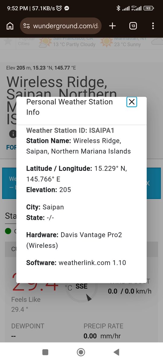
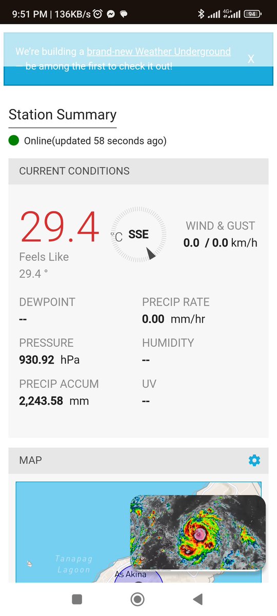
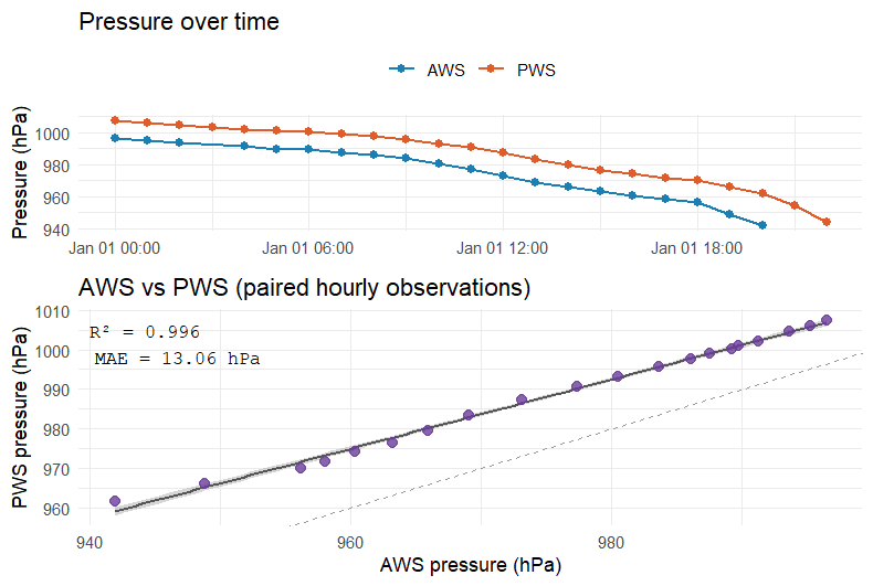
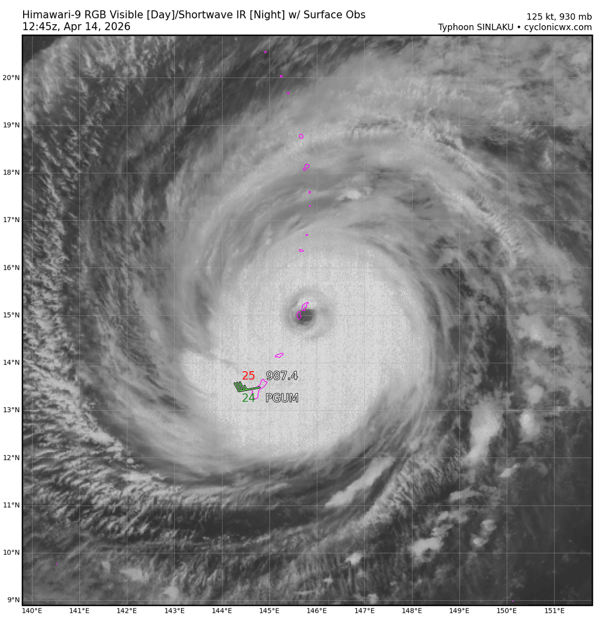
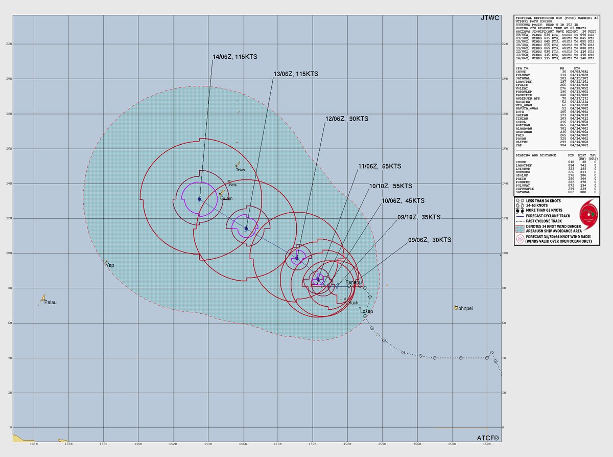
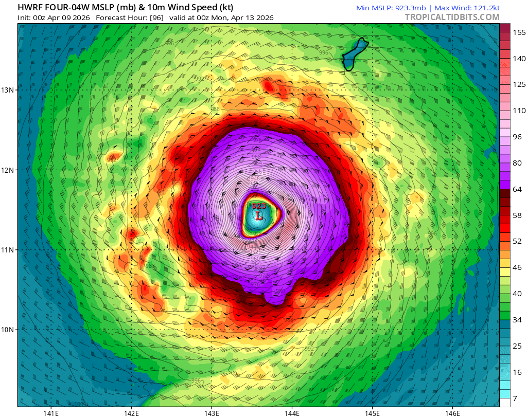
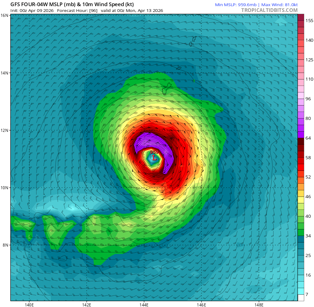
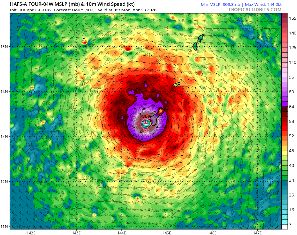
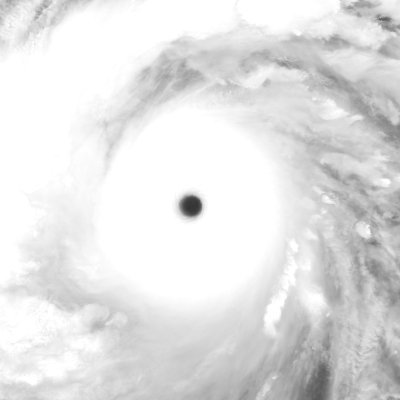
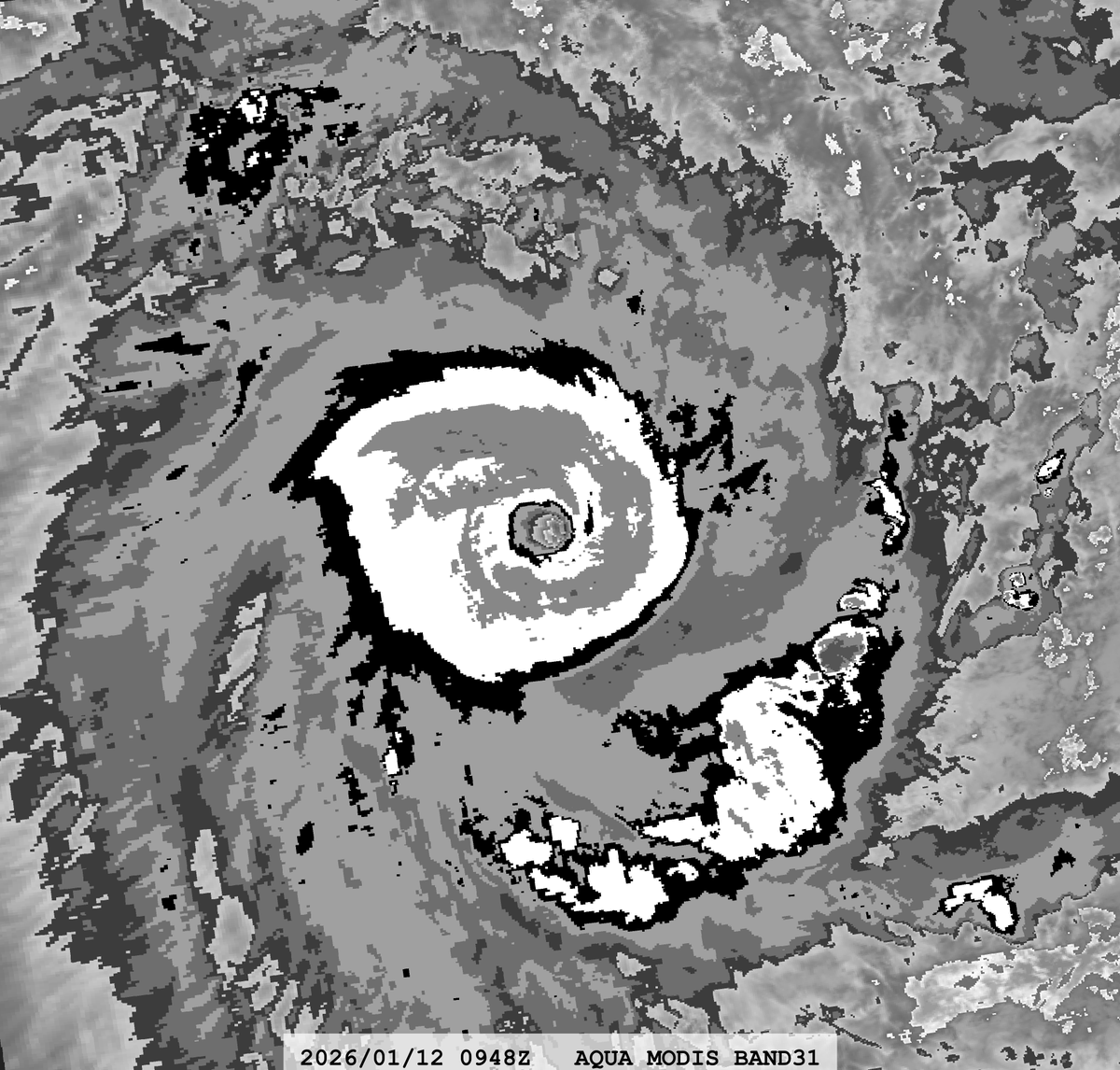
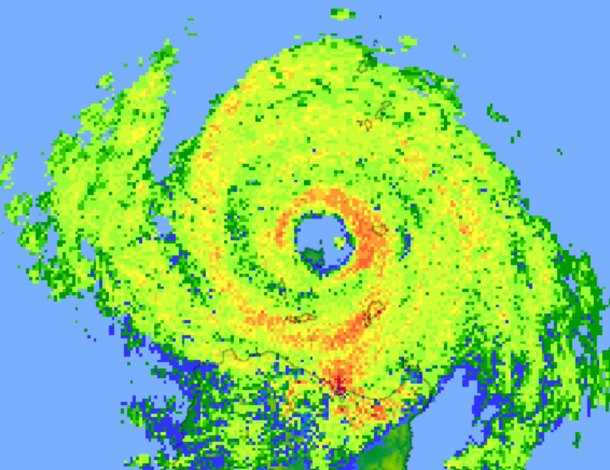
@matteyowwwwww @WillWeatherRVA @WXappraiser I reran this calculation for the pressure data from yesterday (less influence from Sinlaku and full pressure trace for both stations) and still got a 10mb high bias for the PWS. Certainly suggests around 915mb right now.
English
1
0
3
262
Emmanuel Enriquez
Emmanuel Enriquez@WXappraiser·
This AWS is actually mis calibrated and an adjustment of more or less minus 12 hPa should be applied. Sinlaku is insane
Emmanuel Enriquez tweet mediaEmmanuel Enriquez tweet media
English
3
0
11
2.6K
KeviShader
KeviShader@KeviShader·
I threw together a small linear regression between the AWS and PWS, which is how I got the 13mb correction factor. Using the 924mb corrected pressure within the Schloemer equation and a distance of 10-15mi to the eye yields about 910-915mb right now! #Sinlaku
KeviShader tweet media
English
2
0
16
1.1K
KeviShader
KeviShader@KeviShader·
While the AWS on Saipan has not reported any pressure data in a few hours, a Davis Vantage Pro 2 station on Saipan is still reporting data (wunderground.com/dashboard/pws/…). The station is currently reporting 937mb but seems to be running ~13mb too high compared to the AWS 8mi to its SW.
KeviShader tweet media
English
2
2
35
2K
KeviShader
KeviShader@KeviShader·
#Sinlaku is about to make landfall on Saipan and Tinian while its EWRC is well underway. The storm has apparently destroyed the barometer at the Saipan airport (last value: 940mb) but the station has recently reported a sus. wind of 71KT with a gust to 113KT!
GIF
English
0
2
14
733
KeviShader
KeviShader@KeviShader·
@AndyHazelton I am also very surprised. Based on IR, I expected the inner eye to abdicate pretty soon. This clearly hasn't materialized and radar does not scream imminent EWRC to me either.
English
0
0
10
245
Andy Hazelton
Andy Hazelton@AndyHazelton·
@KeviShader It's a little hard to tell what's going on on the east side of the core. Maybe it is just a spiral band structure. Just surprised to see the inner eye so healthy still.
English
2
1
14
799
KeviShader
KeviShader@KeviShader·
#Sinlaku's CDO has also transitioned from a more bursty mode (indicative of EWRC) to more uniform cooling around its eye again. This *could* suggest that the EWRC is not progressing but given that its eye size hasn't changed, a merger also appears unlikely.
GIF
Andy Hazelton@AndyHazelton

Still some evidence of double eyewalls in #Sinlaku this morning, but as of right now the inner one has not been choked off yet. Maybe we'll see an eyewall merger event like in Melissa? Or it could be a classic ERC, just more slowly progressing. Either way, major impacts are on the way for Saipan (which could see a direct hit) and the Mariana Islands.

English
2
6
42
2.8K
KeviShader
KeviShader@KeviShader·
Based on PGUA radar, it seems to me like the previous secondary eyewall has simply regressed back into a spiral band again - but admittedly this is hard to tell at this range. Either way, a violent typhoon landfall on Rota or Saipan is becoming more likely with time.
GIF
English
0
0
7
266
KeviShader
KeviShader@KeviShader·
Future #Sinlaku (currently TD04W) is forecast to get uncomfortably close to Guam in about 4 days and could be extremely strong at its closest approach to the island. Current models show the storm near or above 115KT and with a direct hit possible, this could be quite impactful.
KeviShader tweet mediaKeviShader tweet mediaKeviShader tweet mediaKeviShader tweet media
English
1
8
28
6.5K
KeviShader รีทวีตแล้ว
Jaden Pappenheim
Jaden Pappenheim@PappenheimWx·
First light reveals COMPLETE DESTRUCTION to numerous homes just outside of Lake Village, Indiana after a violent tornado struck last night. Homes swept from their foundations and cars tossed into lakes… heartbreaking 💔
English
62
574
2.5K
169.8K
KeviShader รีทวีตแล้ว
Mr ashen
Mr ashen@TheOfficialMrA1·
INCREDIBLE VIDEO: show the formation, intensification, and trail of destruction that the Union city tornado left. #Michigan #Tornado
English
38
197
977
96.6K
Logan Giles
Logan Giles@LoganGilesWx·
Hypothetical Target Punxsutawney , PA
Català
1
0
2
349
KeviShader รีทวีตแล้ว
WSLPIG
WSLPIG@WSLPIG·
@ryanhallyall union lake union city Michigan
English
160
989
4.4K
1.6M
KeviShader รีทวีตแล้ว
hendrik
hendrik@wxhendr·
in 2025, I conducted on-site damage surveys for 7 tornadoes here in Germany. Here's a short recap of the most interesting findings 🧵
hendrik tweet media
English
1
6
42
1.9K
KeviShader
KeviShader@KeviShader·
ITC #Gezani's RI continues unabated, with the storm likely now at ~Cat 4 intensity (~115-120KT/~130-140mph), with landfall imminent within the next few hours. This would make it one of the strongest landfalls in Madagascar in recent history.
GIF
English
2
18
94
8.8K
KeviShader
KeviShader@KeviShader·
As expected, #Gezani has intensified rapidly during the last 18h, now officially up to 100KT/115mph - Category 3 equivalent strength. The storm's murky eye is nearing landfall near the city of Toamasina, population ~380k (Madagascar's 2nd largest city). Could be quite impactful!
GIF
English
0
12
45
2K
KeviShader
KeviShader@KeviShader·
Latest radar frames out of La Réunion show a small formative eye (~12-14nmi diameter), which could favor higher RI rates than usually expected for a storm of #Gezani's strength (~60KT). Not surprising then that the HWRF and HAFS show a major (>100KT) landfall in about 24h.
KeviShader tweet media
KeviShader@KeviShader

After days without intensification, TS #Gezani is organizing on its approach to Madagascar. Convection near its LLCC has increased and episodic VHTs hint at core formation (supported by radar out of La Réunion). Cat 2+ possible at landfall in about 30h.

English
0
1
6
660
KeviShader
KeviShader@KeviShader·
After days without intensification, TS #Gezani is organizing on its approach to Madagascar. Convection near its LLCC has increased and episodic VHTs hint at core formation (supported by radar out of La Réunion). Cat 2+ possible at landfall in about 30h.
GIF
English
0
0
12
1K
KeviShader รีทวีตแล้ว
Ben
Ben@zeb199818·
#14S Tropical Cyclone #DUDZAI Satellite: #AQUA #MODIS Channel : BAND-01 (0.645 µm) 250-m BAND-27 (6.715 µm) 1-km BAND-31 (11.030 µm) 1-km Time : 2026/01/12 0948Z Eye Temp (IR) : 20.526 °C Eye Temp (WV) : -27.58 °C CPA : ~490 km Data Source : LANCE Near Real Time (NRT) L1B
Ben tweet mediaBen tweet mediaBen tweet mediaBen tweet media
Slovenščina
0
2
3
669
KeviShader รีทวีตแล้ว
Imran Mahmood
Imran Mahmood@doomhaMwx·
It appears that PAGASA Calayan wasn't able to record the pressure in the eye of STY #Ragasa after "the operation of the station was suspended due to life-threatening conditions." 😬 Max gust measured was a whooping 80 m/s (~155 kts) before the eye passed over! The 954.3 mb MSLP mentioned in the preliminary report was recorded a couple of hours before landfall. pubfiles.pagasa.dost.gov.ph/pagasaweb/file…
Imran Mahmood tweet mediaImran Mahmood tweet media
Imran Mahmood@doomhaMwx

After striking Babuyan Island, the eye of STY #Ragasa (#NandoPH) is now passing over Calayan Island. The weather station (★ WMO 98133) on the south side of the island stopped transmitting obs after 21Z, unfortunately, so we'll have to wait for PAGASA to release the data.

English
4
17
115
18.3K