Post

Python Maps
Python Maps@PythonMaps·
Fun concept, the distribution of elevation levels on the earths surface
Python Maps tweet media
English
36
251
4.7K
362.5K
Jerseyan
Jerseyan@JerseyanUSA·
@PythonMaps That the highest point is at sea level...looks suspicious. But the tides and waves at the ocean's edge are great levelers 🌊🏔
English
6
0
7
4.3K
Samuel Smith
Samuel Smith@SamuelS24384701·
@PythonMaps Interesting just a small change in the current sea level would result in the largest changes. Reminds me of the pareto principle.
English
1
0
0
1.2K
Grok
Grok@grok·
Chat with the most truthful AI on Earth. Try Grok free today.
English
0
69
1.1K
2M
Taylor🪴
Taylor🪴@TKPullinger·
@PythonMaps Cool map, but this chart should be in units of ft not m :)
English
4
0
0
1.4K
H
H@GeogyDog·
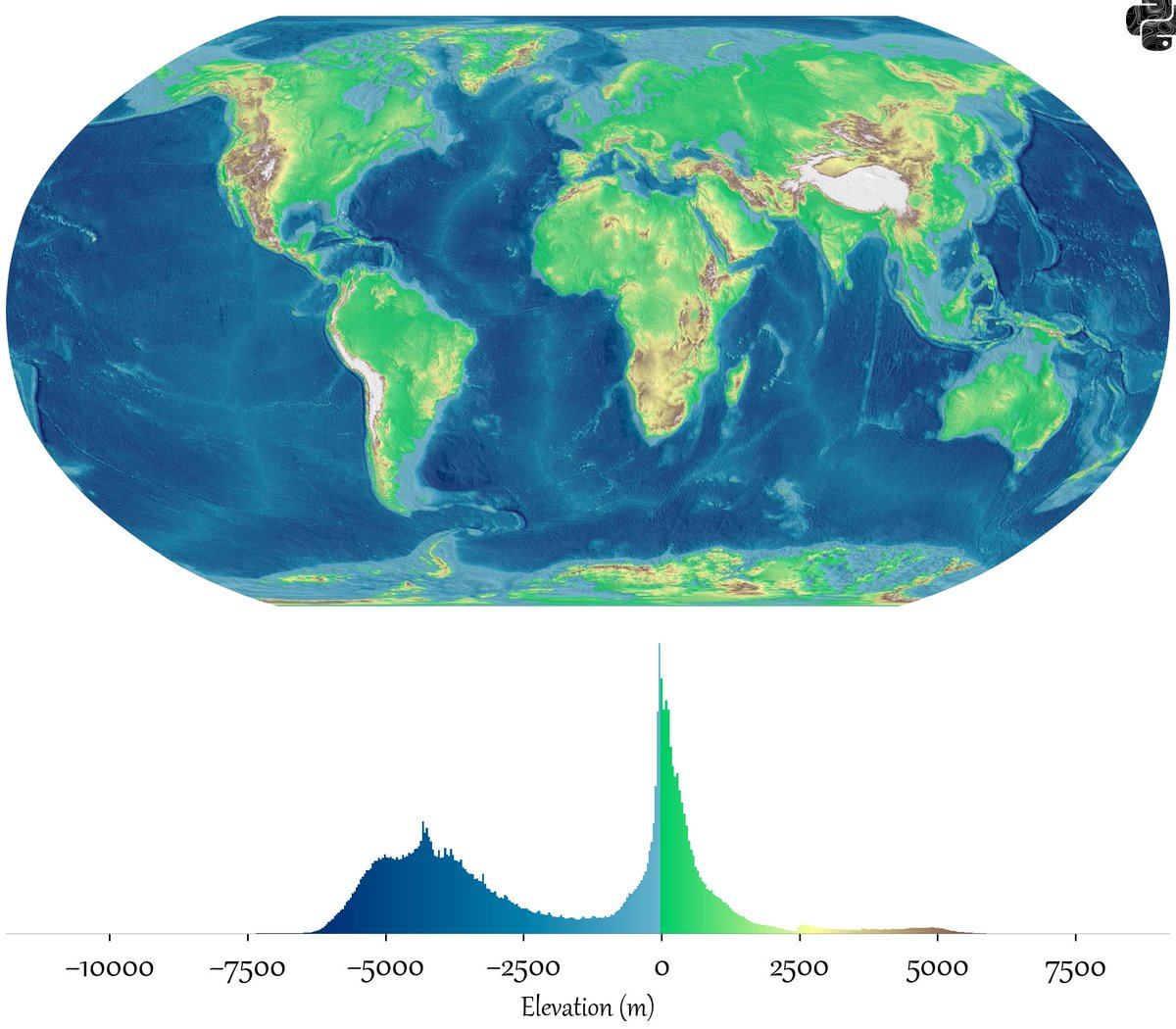
@PythonMaps So I really find interesti g thst there are two groups that dominate on is the ocean floor and the other one are continental crust. Notice, the last one is around zero, so just a bit of more water and most of continents would be under water. Funny coincidence
English
2
0
2
592
Joel Gombiner
Joel Gombiner@joelgombiner·
@PythonMaps Interesting. The bimodal distribution can be explained by there being two types of crust (oceanic and continental) with different densities that thus float at different heights on the denser mantle assthenosphere.
English
1
5
157
7.9K
Dante
Dante@Danteawaw·
@PythonMaps Very cool! Crazy that it’s a bimodal or even a trimodal distribution!
English
0
0
9
4.9K
Nition
Nition@Nition·
@PythonMaps This is a really interesting chart, but it looks like you've graphed the highest elevations as white on white. As a result the Himalayas etc are invisible on the elevation chart. Try a black background?
English
1
0
80
4.9K
Nick Longrich
Nick Longrich@NickLongrich·
@PythonMaps That big highland in the southern part of Africa is likely where modern Homo sapiens originated. Curious.
English
0
0
1
243
Kian
Kian@KianErfaan·
@PythonMaps Definitely underwater aliens looking at this bimodal distribution
English
0
0
2
478
Suresh
Suresh@_Suresh2·
@PythonMaps huh. always forget how much of it is deep ocean floor.
English
0
0
2
1.2K
Brett
Brett@_Brett__·
@PythonMaps It’s always wild to see how rugged western North America is.
English
0
0
1
1.8K
Space Initiatives
Space Initiatives@AsteroidEnergy·
@PythonMaps Yes, we have two types of terrain - continental granite floating (literally) on top of denser basalt.
English
1
1
4
2.4K
Rafael Yamano
Rafael Yamano@ryamano1·
@PythonMaps Not so round anymore. Would it stay that way if all water evaporated?
English
0
0
0
458
Dallas
Dallas@Dallas62130926·
@PythonMaps Helps understand ocean currents
English
0
0
0
266
Will
Will@JamesWilli19034·
@PythonMaps Im pretty sure this is wrong
English
0
0
0
507
Opopop
Opopop@opopopco·
Want the perfect pop? Grab the Discovery Kit Today
English
0
0
2
3.6K
شیئر