André Monette

4.1K posts

André Monette banner
André Monette

André Monette

@AndreMonette_MM

Chef d'équipe de la météorologie à @meteomedia, je suis passionné de statistique et de la météo du Québec. Friand de sports, cinéma et d'actualité!

Montréal Katılım Ekim 2013
247 Takip Edilen2K Takipçiler
André Monette
André Monette@AndreMonette_MM·
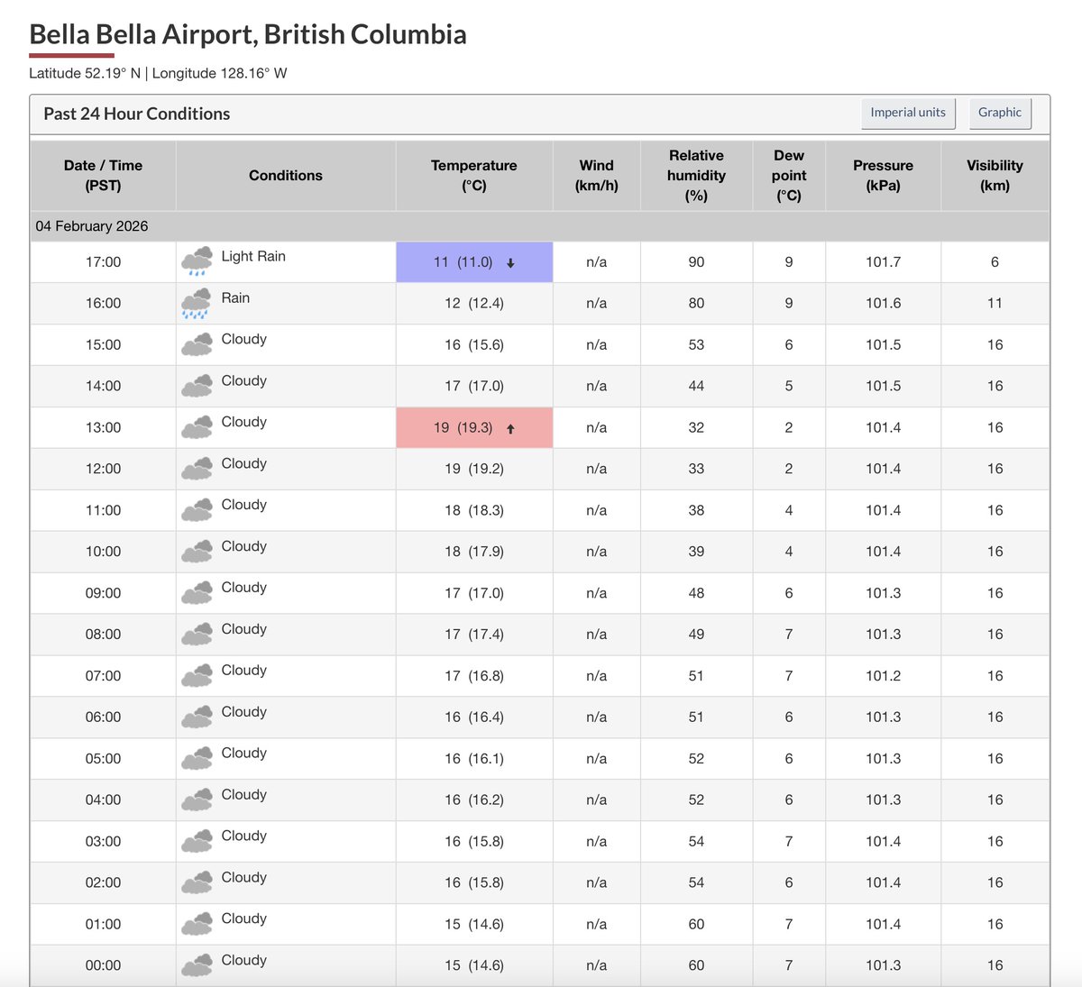
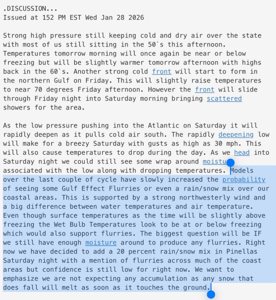
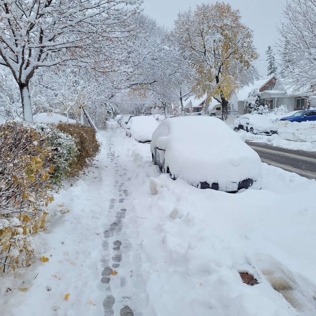
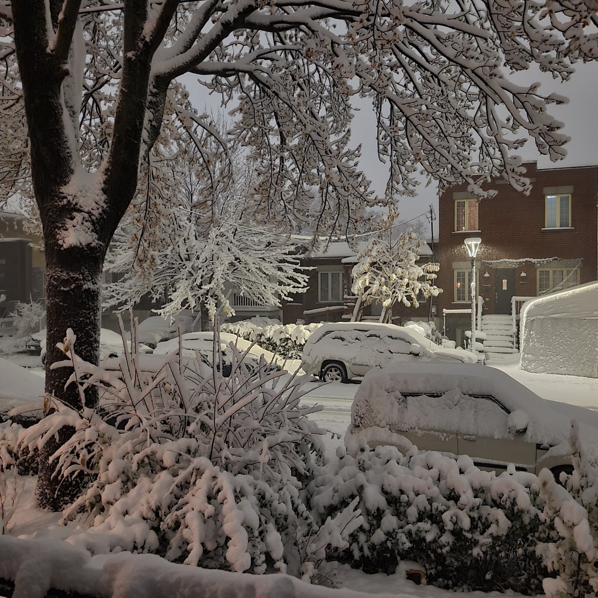
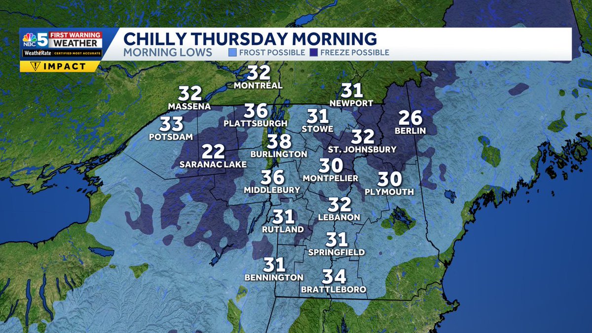
@AndrewMyNBC5 Very interesting data. Thanks for sharing. Nothing yet in Montréal FYI.
English
0
0
0
48
Andrew Grautski
Andrew Grautski@AndrewMyNBC5·
@AndreMonette_MM Hi André, we don’t have a legend, but colors refer to when leaves first formed. Greens/lighter blues are more mature leaves. Darker blues mean buds recently formed. Data is from: usanpn.org/data/maps/spri…. See below, just with a different color table than in the video.
Andrew Grautski tweet media
English
1
0
1
20
Andrew Grautski
Andrew Grautski@AndrewMyNBC5·
Snow showers for some towns tonight 🌨️, but sunshine and milder weather arrive late week ☀️. Leaf-oit and Hummingbird migration underway and set to continue.
English
1
0
0
77
Thierry Goose
Thierry Goose@ThierryGooseBC·
Record mildness in western Canada! AB 🌡️21.3°C Hays 🌡️21.2°C Barnwell 🌡️21.0°C Grassy Lake & Fincastle 🌡️20.8°C Vauxhall BC 🌡️19.5°C Bella Bella ➡️ 1.5°C from the February provincial record 🌡️18.9°C Cathedral Point 🌡️18.8°C Bella Coola 🌡️18.1°C Tatlayoko Lake 🌡️17.6°C Tofino
Thierry Goose tweet mediaThierry Goose tweet media
English
10
15
73
10.7K
André Monette retweetledi
Mike Gagliardi (Tropics)
Mike Gagliardi (Tropics)@Mike__Gagliardi·
History: For the first time in likely 37 years, NWS Tampa Bay mentions snow in the area Forecast Discussion.
Mike Gagliardi (Tropics) tweet media
English
8
123
829
66.6K
Thierry Goose
Thierry Goose@ThierryGooseBC·
🚨 Extreme cold in NW Canada! 🚨 🌡️-55.2°C Braeburn, Yukon [preliminary min] is the lowest temperature recorded in Canada since January 1999! 🥶 More details later. #YTstorm
Thierry Goose tweet media
English
14
60
315
109.4K
André Monette retweetledi
Tyler Jankoski NBC5 ☀️
Tyler Jankoski NBC5 ☀️@TylerJankoski·
New record on Mansfield! 38 inches of depth on November 17 breaks the old record of 30 inches in 1999.
Tyler Jankoski NBC5 ☀️ tweet media
English
1
2
3
1.5K
Thierry Goose
Thierry Goose@ThierryGooseBC·
❄️ Remarkable snow event in southern Quebec, with locally over 20-30 cm. Max snow depths: 33 cm Bagotville & Roberval 25 cm Granby 24 cm Saint-Germain-de-G. 23 cm McTavish (downtown Montreal 📷) & L'Assomption 21 cm Frelighsburg & Sainte-Anne-de-B. 16 cm Montreal YUL #QCstorm
Thierry Goose tweet mediaThierry Goose tweet mediaThierry Goose tweet media
English
2
9
55
6K
André Monette
André Monette@AndreMonette_MM·
@MyRadarWX Great analysis, but a bit early in my opinion to be affirmative like this for these 2 scenarios (based on GFS/Euro). With the new models at 12Z, we could so completey different scenarios.
English
0
0
0
943
MyRadar Weather
MyRadar Weather@MyRadarWX·
MELISSA UPDATE for Wednesday, October 22 – two main scenarios are emerging with Melissa's path/intensity, and neither are good. If a northerly track is realized, Melissa could stall south of Haiti, or eventually come ashore, and dump extreme rainfall – 20 to 30 inches. Combined with deforestation and socioeconomic issues, that would lead to crippling flooding and deadly mudslides. That would be a humanitarian disaster. If a more westerly track is realized, Melissa could become a Category 4 or 5 hurricane in about 5 or 6 days' time over the western Caribbean. But where it would go from there remains uncertain. Right now, Melissa is a bit lopsided. It's being battered by shear, or disruptive changing winds with height. That shear has blown most of Melissa's thunderstorms to the east of its low-level center. That's why Melissa will strengthen slowly in the days ahead. If Melissa manages to become stronger in the next day or two, it will be an overall stronger system in the short term – likely a higher-end tropical storm or borderline hurricane. That would make it a bit taller (taller thunderstorms), which would catch the stronger winds aloft and blow the system northward. (Think about a sailboat hoisting its sails and catching the wind.) That scenario, which is less likely, would take it closer to Haiti and bring flooding. But if Melissa strengthens more gradually or remains constant over the next couple days, it will meander very slowly to the west. By late week, however, shear may relax, allowing it to rapidly strengthen over the weekend as it passes over Caribbean Sea surface temperatures between 86 and 89 degrees. Robust oceanic heat content (fuel) could support a monster. But when would it turn? And where would it go? TBD. For now, I'm leaning toward the latter scenario.
MyRadar Weather tweet media
English
3
20
109
49.4K
André Monette retweetledi
meteomedia
meteomedia@meteomedia·
La sécheresse actuelle met en lumière une faille majeure dans notre système de gestion de l'eau. ow.ly/c6b550XegR9 #MétéoQc
Français
2
1
6
897
André Monette retweetledi
The Weather Channel
The Weather Channel@weatherchannel·
The 2025 hurricane season is the first time in 28 years when there hasn't been a named storm in the Caribbean. But with Melissa potentially on the horizon, that could change things. weather.com/storms/hurrica…
English
9
31
93
26.6K
André Monette retweetledi
Tyler Jankoski NBC5 ☀️
Tyler Jankoski NBC5 ☀️@TylerJankoski·
We've been talking about snow in the White Mountains for days, and here it is!
Tyler Jankoski NBC5 ☀️ tweet media
English
1
3
8
658
André Monette
André Monette@AndreMonette_MM·
@ECCCMeteoQC J'ai 45 mm à St-Colomban, il y a aussi un 63 mm à Prevost sur Cocohars.
Français
0
0
0
48
Andrew Grautski
Andrew Grautski@AndrewMyNBC5·
Widespread frost expected Thursday morning, except for towns along the shore of Lake Champlain. *Hard freezes* likely for the Adirondacks, much of the NEK and highest parts of southern VT. Low temperature range: 22 (Saranac Lake) to 38 (Burlington).
Andrew Grautski tweet media
English
1
1
0
221
André Monette retweetledi
Mount Pleasant PD
Mount Pleasant PD@MountPleasantPD·
A bit too much excitement for a Monday! The lightning strike caused our power outages and traffic delays. Fortunately, no one was injured, and @DominionEnergy responded quickly, restoring power and removing the downed wires.
English
52
325
1.1K
200.4K
André Monette
André Monette@AndreMonette_MM·
Le maximum de 37,5C à ZBF/Bathurst est un record mensuel pour la station, ancien 37,2C en 1935. Le record absolu est de 37,6C le 19 juin 2024. #nbwx
Français
0
0
1
163
André Monette
André Monette@AndreMonette_MM·
@ECCCMeteoQC Les intervalles de l'échelle ne sont pas optimales pour un bilan de précipitations de 15 jours.
Français
1
0
0
111