
Andy Foerster
345 posts

Andy Foerster
@AndyGump69
Minto Fire,Welder fitter,Livin the dream
Katılım Nisan 2013
355 Takip Edilen139 Takipçiler

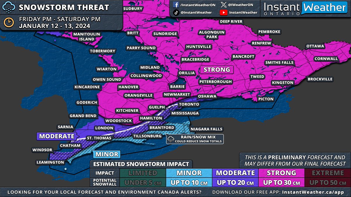
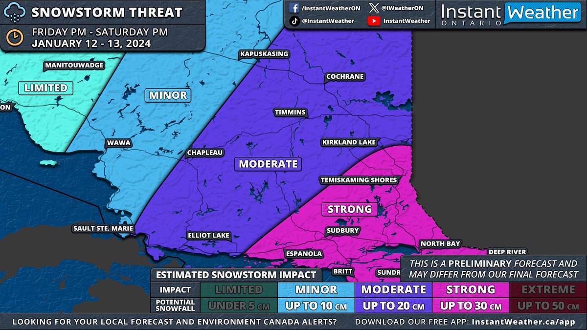
#ONStorm #ONwx ❄️ SNOWSTORM PREVIEW: Widespread Significant Snowfall of Up to 30cm on the Way for Most of Southern & Northeastern Ontario
📅 Friday, January 12 - Saturday, January 13, 2024
——
After reviewing the latest model data from this evening, it appears increasingly likely that Southern Ontario will experience its first widespread significant snowstorm of the season starting Friday.
We'll publish a detailed forecast article in the morning. For now, here's an early look at the forecast maps based on this evening's model runs. Remember, this forecast is preliminary, as the storm is still about 36 hours away. Although there's time for model adjustments, any changes should be minor given the high confidence in this event.
Before Friday's main event, a weaker system will pass through Southern Ontario on Thursday morning and afternoon. While significant accumulation isn't expected, a few centimetres may cover Central and Southwestern Ontario, including the Greater Toronto Area. Lake enhancement east of Lake Huron could increase totals to 3-6cm in the Owen Sound to London corridor, tapering off by late afternoon.
The main storm is expected to start between 2-5 PM on Friday, beginning in Extreme Southwestern Ontario. Initial bands could bring heavy snowfall, with rates of 5-10cm per hour, and the potential for thundersnow, a phenomenon we haven't seen since last winter's major blizzard. ⚡️
Strong wind gusts of 60-80km/h, locally reaching up to 90km/h, will likely create treacherous driving conditions. Areas might experience localized blizzard conditions, especially in Southwestern Ontario, the Golden Horseshoe, and parts of Central Ontario.
These heavy snowfall rates will move through Southwestern Ontario, affecting London, Kitchener, and Hamilton by early evening. The Greater Toronto Area will experience this intense snow later in the evening, eventually spreading northeast to Central and Eastern Ontario, continuing overnight into early Saturday.
While the heaviest snowfall will be brief, moderate snow will persist behind the initial band throughout the night into Saturday. Around the Lake Ontario and Erie shorelines, a brief surge of warmer air Friday night into Saturday morning could lead to a temporary changeover to rain, potentially reducing snowfall totals in the Niagara region and parts of the Greater Toronto Area near the lakeshore.
A sharp cooldown early Saturday morning will bring temperatures back below freezing, switching precipitation back to snow and creating a risk of flash freezing. Icy road conditions are likely on Saturday morning.
By Saturday's end, most of Southern Ontario, excluding Deep Southwestern Ontario and the Niagara region, can expect 15-30cm of snow. The Lake Erie shoreline and Niagara region are projected to receive 5-15cm, while the Greater Toronto Area could see 10-20cm, with higher amounts further from the lakes.
This event will also affect Northeastern Ontario with over 20cm of snow on tap for Sudbury, North Bay and Temiskaming Shores starting late Friday evening and continuing through Saturday.
As the system exits, lake effect snow will intensify late Saturday around Lake Huron and Georgian Bay, with snow squalls likely into next week. This could result in substantial snowfall over the week in areas like Goderich, Kincardine, Hanover, Owen Sound, Wiarton, Barrie, Orillia, Midland, Bracebridge, Huntsville, Parry Sound, Britt and Sundridge
We'll provide more details in our full forecast article on Thursday morning and a final forecast with precise totals either Thursday evening or Friday morning.
- Brennen
English
Andy Foerster retweetledi

🚨 JOHNNY GIVEAWAYS IS BACK🚨
We are giving away 2 tickets 9 rows up to Fridays game against the LA Angels. Rules:
1. Follow us on twitter
2. Retweet this tweet
3. Be respectful and responsible
ANNOUNCING WINNER ON TONIGHTS PODCAST.
#ThankYouGate14

English
@WightmanRob @homerbob49 I think he wants way to much money. But I do agree with moving Bo and that’s about all I want to see leave they can’t trad the team for one guy and there gonna need money to keep Jr and everyone else. I like Bo but he isn’t what I though he was going to be
English
@homerbob49 I think we need pitching more then another outfielder. And Rogers is going to have to pony up soon enough to keep all these yong guys that need to stay
English
Andy Foerster retweetledi

Andy Foerster retweetledi

Power Outage: Clifford
Please be advised Westario Power customers in the Village of Clifford are experiencing an unplanned outage as a result of Loss of Supply.
The estimated time of restoration is currently unknown.
We appreciate your patience and support.

English
Andy Foerster retweetledi

I’ve teamed up with @pingcanada to give one lucky winner my autographed special-edition PLD staff bag that I used at The Players.
RETWEET and make sure you’re following @pingcanada & me. One random winner will be announced here on Friday at 8pm ET #PlayYourBest

English

Andy Foerster retweetledi


Andy Foerster retweetledi

English
Andy Foerster retweetledi

As of 6:30 Friday AM there are still spaces open for COVID-19 vaccines at the Davidson Centre in #Kincardine today (May 7) Book on the LOCAL site here: ow.ly/P0Om50EH67e Those over 50, farmers, food distribution workers and more are eligible.

English
Andy Foerster retweetledi

We’re celebrating 40 years! To celebrate, we’re giving away a Yeti cooler and $250 in gift cards! To be entered just like and retweet! Contest ends May 17th.


English
Andy Foerster retweetledi

Waterloo regional police say they don't plan to randomly stop people or vehicles to ask why they are out of their homes under the province-wide stay-at-home order. kitchener.ctvnews.ca/waterloo-regio…
English

Andy Foerster retweetledi