Chris Phillips

31.7K posts

Chris Phillips banner
Chris Phillips

Chris Phillips

@Chrisweather

Weather for Indiana, Kentucky, and Ohio.

Cincinnati, OH Katılım Ocak 2013
261 Takip Edilen2K Takipçiler
Chris Phillips
Chris Phillips@Chrisweather·
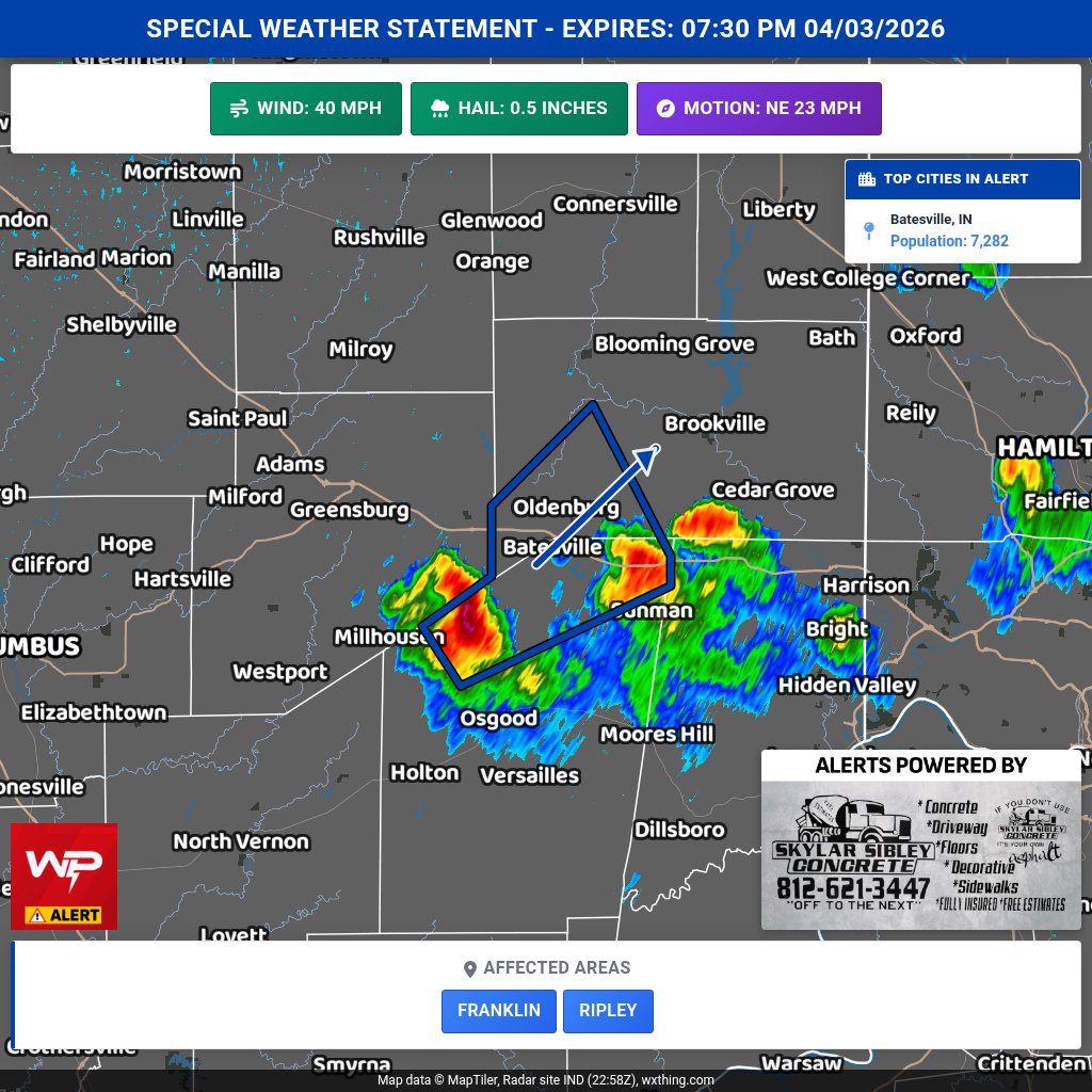
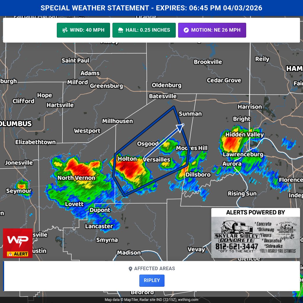
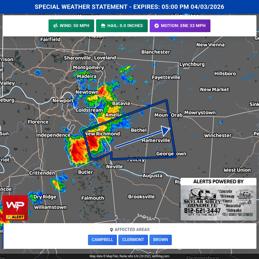
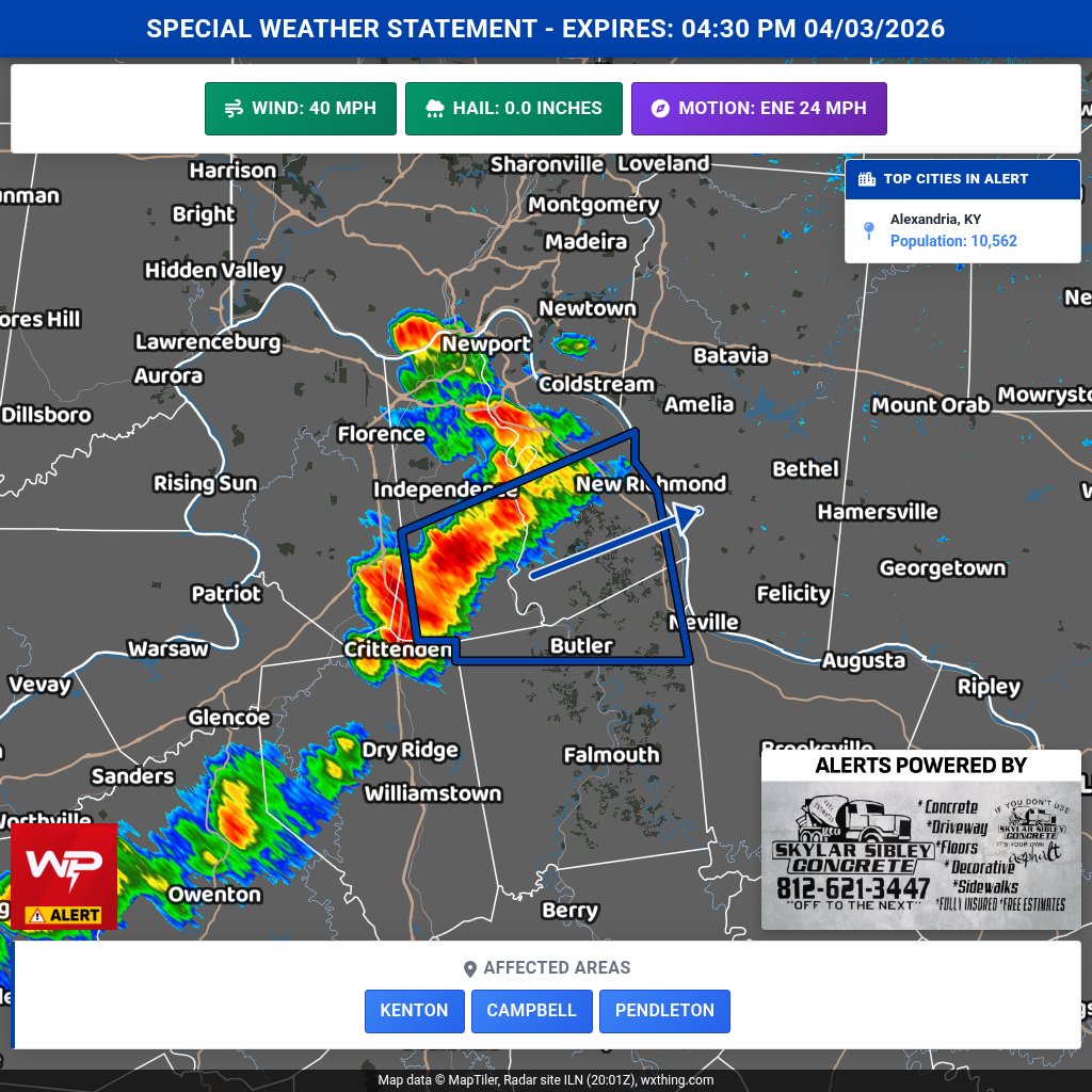
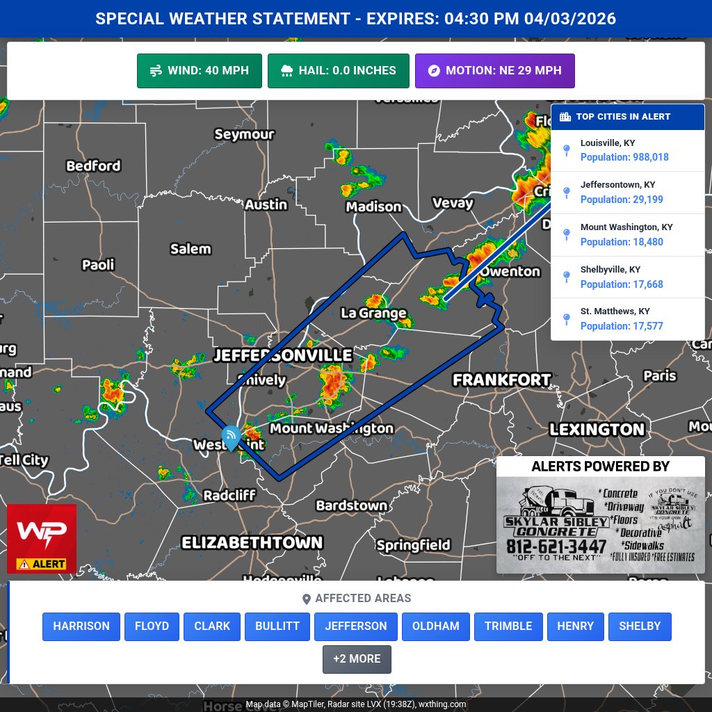
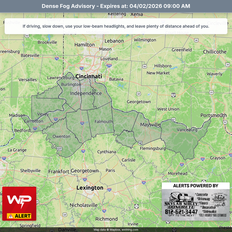
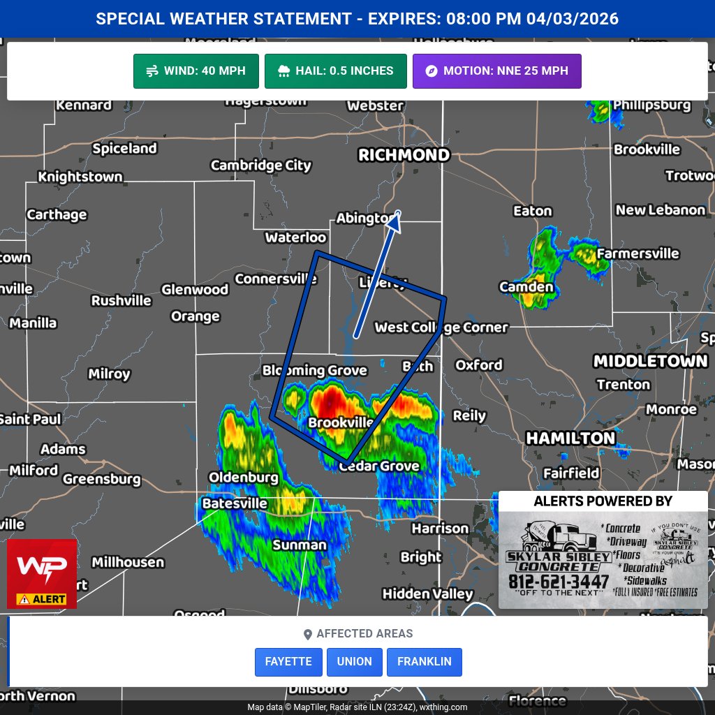
Special Weather Statement for Fayette, Union, Franklin & Others until 8:00 PM. Wind gusts up to 40 mph and 0.5 in hail possible. Radar indicated a strong thunderstorm near Brookville moving NE. Seek shelter indoors.
Chris Phillips tweet media
English
0
0
0
49
Chris Phillips
Chris Phillips@Chrisweather·
Special Weather Statement for Franklin and Ripley until 7:30 PM 04/03. Wind gusts up to 40 mph and 0.5 in hail possible. Radar indicated. Secure loose items; if outdoors, seek shelter in a sturdy building.
Chris Phillips tweet media
English
0
0
0
58
Chris Phillips
Chris Phillips@Chrisweather·
Special Weather Statement for Ripley until 6:45 PM. Wind gusts up to 40 mph and pea-size hail possible. Radar indicated a strong thunderstorm near Versailles moving NE at 25 mph. Seek shelter indoors if outdoors.
Chris Phillips tweet media
English
0
0
0
60
Chris Phillips
Chris Phillips@Chrisweather·
Special Weather Statement for Wayne & Fayette until 6:30 PM. Wind gusts up to 40 mph and 0.5 in hail possible. Radar indicated. Secure loose items and seek shelter in a sturdy building if outdoors.
Chris Phillips tweet media
English
0
0
0
73
Chris Phillips
Chris Phillips@Chrisweather·
Special Weather Statement for Fayette, Pickaway, Clinton, Ross, Highland until 6:15 PM ET. Strong t-storms may bring wind gusts up to 40 mph. Radar indicated. Secure loose items; avoid downed limbs and seek shelter indoors if outdoors.
Chris Phillips tweet media
English
0
0
0
39
Chris Phillips
Chris Phillips@Chrisweather·
Special Weather Statement for Campbell, Clermont, Brown & Others until 5:00 PM EDT. Wind gusts up to 50 mph possible. Radar indicated. Gusty winds may knock down tree limbs and blow unsecured objects. If outdoors, seek shelter in a sturdy building.
Chris Phillips tweet media
English
0
0
1
62
Chris Phillips
Chris Phillips@Chrisweather·
Special Weather Statement for Kenton, Campbell, Pendleton & Others until 4:30 PM ET. Wind gusts up to 40 mph are possible. Radar indicated a strong thunderstorm near Claryville moving E. Secure loose items; seek shelter indoors if outdoors.
Chris Phillips tweet media
English
0
0
0
49
Chris Phillips
Chris Phillips@Chrisweather·
Special Weather Statement for Harrison, Floyd, Clark & Others until 4:30 PM ET. Strong storms may bring wind gusts up to 40 mph and torrential rain. Lightning and localized flooding possible. Seek shelter indoors; don’t drive through flooded roads.
Chris Phillips tweet media
English
0
0
0
61
Chris Phillips
Chris Phillips@Chrisweather·
Special Weather Statement for Orange & Others. Increasing SW to NE gusts late this morning through afternoon, 30-40 mph. Gusts diminish toward sunset. Use caution with high-profile vehicles, esp. on E-W roads like I-64.
Chris Phillips tweet media
English
0
0
1
64
Chris Phillips
Chris Phillips@Chrisweather·
Special Weather Statement for Central IN & Others. Patchy dense fog may reduce vis to 1/4 mi or less at times this morning. Fog may suddenly worsen; dissipates mid-late AM. Slow down and allow extra time.
Chris Phillips tweet media
English
0
0
0
65
Chris Phillips
Chris Phillips@Chrisweather·
Special Weather Statement for Franklin, Ripley, Dearborn & Others. Patchy dense fog early this morning causing rapidly changing visibility. Slow down, use low beams, and allow extra travel time.
Chris Phillips tweet media
English
0
0
0
56
Chris Phillips
Chris Phillips@Chrisweather·
Dense Fog Advisory for Carroll, Gallatin & Others until 9 AM EDT. Visibility 1/4 mi in dense fog. Use low beams, slow down, and allow extra time; use caution when driving.
Chris Phillips tweet media
English
0
0
0
57
Chris Phillips
Chris Phillips@Chrisweather·
Special Weather Statement for Ripley & Others early this morning. Patchy dense fog will reduce visibilities quickly. Use caution while driving and be alert for rapid changes in sight distance.
Chris Phillips tweet media
English
0
0
0
47
Chris Phillips
Chris Phillips@Chrisweather·
Special Weather Statement for Orange, Washington, Scott & Others. Expect increasing SW to NE gusts late AM into afternoon, 30-40 mph. Gusts ease toward sunset. Use caution with high-profile vehicles, esp. on E-W roads like I-64.
Chris Phillips tweet media
English
0
0
0
55
Chris Phillips
Chris Phillips@Chrisweather·
(Event extended) Wind Advisory for Central IN & Others until 7 PM EDT. S winds 15-30 mph with gusts 45-50 mph. Gusty winds may blow down limbs and cause a few outages. Secure loose items.
Chris Phillips tweet media
English
0
0
0
50
Chris Phillips retweetledi
Dakota Smith
Dakota Smith@weatherdak·
Welp this is one of the coolest things I've ever seen. Artemis II 🚀
English
2
145
1K
46.2K
Chris Phillips
Chris Phillips@Chrisweather·
Special Weather Statement for Trimble and Henry & Others until 5:15 PM 04/01/2026. Wind gusts up to 50 mph and 0.5 in hail possible. Radar indicated. If outdoors, seek shelter inside a building.
Chris Phillips tweet media
English
0
0
0
64
Chris Phillips
Chris Phillips@Chrisweather·
Special Weather Statement for Pendleton, Bracken, Robertson, Mason until 5:00 PM. Wind gusts up to 40 mph and 0.5 in hail possible. Radar indicated. Secure loose items; seek shelter in a sturdy building if outdoors.
Chris Phillips tweet media
English
0
0
1
72