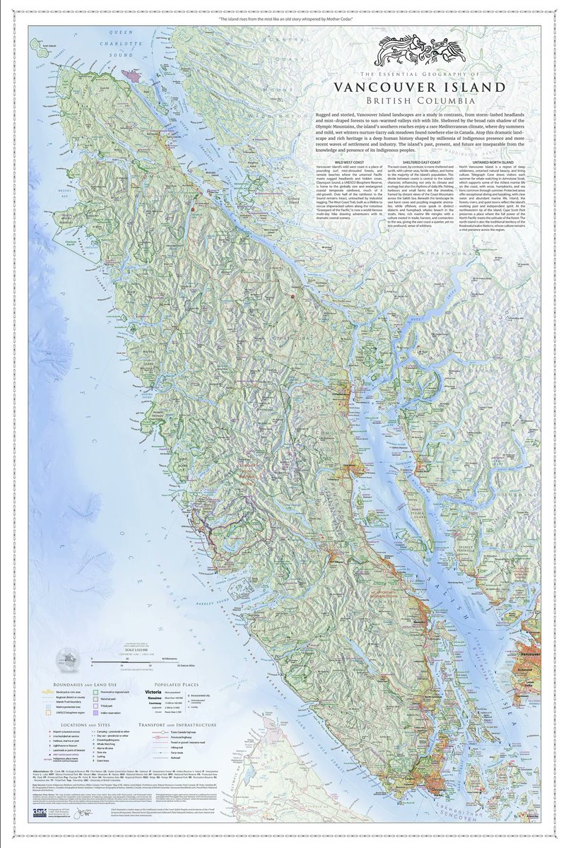
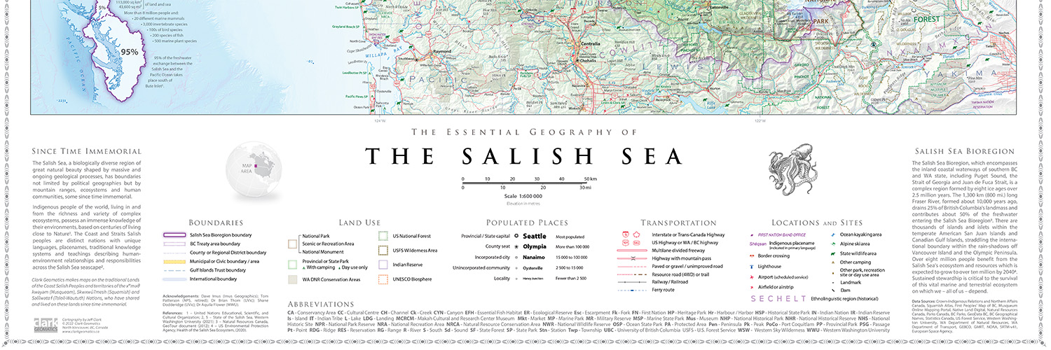
Jeff Clark - Sea To Sky Map - Best of Show!

1.5K posts

Jeff Clark - Sea To Sky Map - Best of Show! banner
Jeff Clark - Sea To Sky Map - Best of Show!

Jeff Clark - Sea To Sky Map - Best of Show!

@ClarkGeomatics

Award-winning Cartographer / Geophysicist / GIS Guy #SalishSeaMap #Cartography #GIS #BC #Backcountry #Mapping #Geography

North Vancouver, BC, Canada Katılım Aralık 2010
803 Takip Edilen948 Takipçiler
Jeff Clark - Sea To Sky Map - Best of Show! retweetledi
Evan Applegate
Evan Applegate@youwillmakemaps·
Canadian excellence: if you're after a wall/trail map of British Columbia, you need to see @ClarkGeomatics He just released the 3x2 ft. "Essential Geography of Vancouver Island," all printed and inspected by the author.
Evan Applegate tweet mediaEvan Applegate tweet mediaEvan Applegate tweet mediaEvan Applegate tweet media
English
1
7
34
1.5K
Jeff Clark - Sea To Sky Map - Best of Show! retweetledi
Evan Applegate
Evan Applegate@youwillmakemaps·
Time to scroll around the most beautiful map ever made: the 1739 "Plan de Turgot," commissioned by the chief merchant of Paris. Every mark was originally engraved into brass plates and the detail is insane, like examining an 8x10 ft. banknote.
English
39
347
4.1K
147.2K
Jeff Clark - Sea To Sky Map - Best of Show! retweetledi
Chris Hadfield
Chris Hadfield@Cmdr_Hadfield·
All the roads in Canada. Reveals much to think about. (map by @EarthArtAus)
Chris Hadfield tweet media
English
200
529
3.8K
396.9K
Jeff Clark - Sea To Sky Map - Best of Show! retweetledi
Qiusheng Wu
Qiusheng Wu@giswqs·
🌍 New Tutorial Alert: Visualizing Google's AlphaEarth Satellite Embeddings in 3D! 🛰️🏙️ Google DeepMind has released AlphaEarth, a groundbreaking satellite embedding dataset on Google Earth Engine. It includes annual global embeddings from 2017 to 2024, where each pixel covers a 10×10 meter area. In this tutorial, you'll learn how to: ✅ Access and visualize AlphaEarth embeddings in 3D ✅ Leverage them for machine learning and change detection 🎥 Watch the tutorial: youtu.be/EGL7fXyA7-U 📘 Try the notebook: leafmap.org/maplibre/Alpha… #GeoAI #geospatial #AI #Python #DeepLearning
YouTube video
YouTube
English
4
134
657
25.8K
Jeff Clark - Sea To Sky Map - Best of Show! retweetledi
Evan Applegate
Evan Applegate@youwillmakemaps·
“Handmade maps in the digital world” is my bailiwick, here are 23 modern map artisans: @ClarkGeomatics Jeff Clark completed a 100-layer 18-month project to map the Salish Sea. @MtnMapper Tom Patterson spent decades mapping for the National Park Service, still releases a banger map every few months AND releases his design files to the public domain. @DonatasBruzas Donatas Bružas is working on an engraving-style 3 ft. globe, makes custom typefaces and the most beautiful computer-mediated hachures you’ve ever seen. @JapanMapping Markus Hauser, trained in Switzerland with decades of experience, makes the best trail maps of Japanese wilderness. @FleischerHannes Hannes Fleischer wanted an old-school pen plotter map, so he lathed and milled his own parts to build the plotter, wrote custom scripts to turn DEMs into hachures, and designed the map with turfjs. Henrik Jonasson made an acre-sized handmade topo map of Sweden #6556712,635602,13z" target="_blank" rel="nofollow noopener">tiles.calazoffice.biz/#6556712,63560… hkartor.se Mike Hall’s incredibly thick reference maps (he draws his own coastlines) thisismikehall.com/europe Dave Imus’s 5 ft. wide maps of the U.S. imusgeographics.com Alex McPhee’s 6 ft. maps of Canadian provinces pronghornmaps.com/saskatchewan/ Andrew Lynch spent years tracking down every NYC rail siding vanshnookenraggen.com/_index/2017/05… Nat Slaughter spent two years walking Central Park to make this central park map davidrumsey.com/luna/servlet/d… Aaron Taveras’s stunning trail maps of the Pacific Northwest cartografix.co Daniel Huffman’s 3 ft. map of Michigan somethingaboutmaps.com/Landforms-of-M… Carl Churchill’s pitch-perfect relief maps in Imhof style flickr.com/photos/cchurch… Bill Marsh’s 30-year project to map Philadelphia store.philamuseum.org/philadelphia-p… Eric Knight’s Nat Geo panoramas ericknightmaps.com/panoramas Marty Schnure’s wilderness maps martyschnure.cargo.site/cartography Margot Dale Carpenter’s landform maps for publishing hartdalemaps.com Jamie Robertson’s trail maps of Big Sky country cairncarto.com/product/public… Mike Hermann’s Pennsylvania trail maps purplelizard.com Maddy Grubb’s Blender maps of mountains maddygrubbmaps.github.io/Maps.html John Tauranac learned Illustrator and walked every block in Manhattan to make his own guide maps johntauranac.com/tauranac_s_lin… Eleanor Lutz is a bio PhD and taught herself how to make all kinds of maps of earth, sky and everything in between eleanorlutz.com/animated-seaso…
Evan Applegate tweet mediaEvan Applegate tweet mediaEvan Applegate tweet mediaEvan Applegate tweet media
Prad Nelluru, quantum satis@pradnelluru

@usgraphics Someone needs to do handmade maps in the digital world. The same underlying data, chosen and arranged by human designers.

English
2
25
187
19.1K
Jeff Clark - Sea To Sky Map - Best of Show! retweetledi
Evan Applegate
Evan Applegate@youwillmakemaps·
WWII editorial maps for Time Magazine by R.M. Chapin
Evan Applegate tweet mediaEvan Applegate tweet mediaEvan Applegate tweet mediaEvan Applegate tweet media
English
11
230
2.1K
145.8K
Jeff Clark - Sea To Sky Map - Best of Show! retweetledi
Evan Applegate
Evan Applegate@youwillmakemaps·
My favorite editorial map: north-down Nile by Laris Karklis for an Oct. 2020 Washington Post story about the Grand Ethiopian Renaissance Dam
Evan Applegate tweet media
English
1
5
52
2.8K
Evan Applegate
Evan Applegate@youwillmakemaps·
Where to find cool old maps No one's favorite map was made after 1980. Bummer, I'm working on it, but you gotta give the people what they want. Poke around these links to find the best extant maps. New York Public Library: digitalcollections.nypl.org/divisions/lion… David Rumsey Map Collection: davidrumsey.com NOAA Historical Map & Chart Collection: historicalcharts.noaa.gov U.S. National Archives: catalog.archives.gov/advancedsearch American Geographical Society Library Digital Map Collection: collections.lib.uwm.edu/digital/collec… Shaded Relief Archive: shadedreliefarchive.com Norman B. Leventhal Map & Education Center Collection: collections.leventhalmap.org/search/commonw… British Library: flickr.com/photos/british… U.S. Geological Survey TopoView: ngmdb.usgs.gov/topoview/ Osher Map Library: oshermaps.org/browse-maps Perry-Castañeda Library Map Collection: maps.lib.utexas.edu/maps/index.html Library of Congress: loc.gov/maps/?q=appoma… Pixeum: pixeum.org/browse_subjects Harvard Library: curiosity.lib.harvard.edu/scanned-maps/c… Map dealers that let you explore their offerings at high res: geographicus.com raremaps.com
Evan Applegate tweet mediaEvan Applegate tweet mediaEvan Applegate tweet media
English
7
11
123
6K
Jeff Clark - Sea To Sky Map - Best of Show! retweetledi
Evan Applegate
Evan Applegate@youwillmakemaps·
Devon, U.K. artist Victoria Rose Richards embroiders rich territories. "I am surrounded by inspiration for my pieces in the endless fields and meadows, lush forests, winding rivers and reaching moorland."
Evan Applegate tweet mediaEvan Applegate tweet mediaEvan Applegate tweet mediaEvan Applegate tweet media
English
2
12
149
5.7K
Jeff Clark - Sea To Sky Map - Best of Show! retweetledi
Julian Hoffmann Anton
Julian Hoffmann Anton@Julian_H0ffmann·
The Great Fire of London – 1666 CE | Affected area in modern-day London. Made in Blender based on the area in ruines mapped by Leake & Leybourne (1667) and Google's photoreal 3D Tiles. I loved making this. London TimeOut even wrote about it:
Julian Hoffmann Anton tweet media
English
1
22
184
6.6K
Jeff Clark - Sea To Sky Map - Best of Show! retweetledi
Evan Applegate
Evan Applegate@youwillmakemaps·
Marine Le Breton draws swirling pen maps of France’s coastal areas and islands; you rarely see a map where the water gets as much ink as the land. Nautical love letters with towns, roads, marshes, tidal flats, creeks, bays, inlets, piers.
Evan Applegate tweet mediaEvan Applegate tweet mediaEvan Applegate tweet mediaEvan Applegate tweet media
English
3
27
289
15.6K
Jeff Clark - Sea To Sky Map - Best of Show! retweetledi
Evan Applegate
Evan Applegate@youwillmakemaps·
Margaret River, Australia cartographer Grant Preller walks the coast, surfs the breaks, then uses Google Earth, 1890s coastline maps, 1:50k topos, a pencil and CorelDraw to create 8-foot-wide maps that show where to catch a sick barrel 🤙 A true go-somewhere mapmaker
Evan Applegate tweet media
GIF
Evan Applegate tweet mediaEvan Applegate tweet media
English
2
16
112
12.9K
Jeff Clark - Sea To Sky Map - Best of Show! retweetledi
non aesthetic things
non aesthetic things@PicturesFoIder·
magellan expedition in 1 minute
English
159
728
6.4K
633K
Jeff Clark - Sea To Sky Map - Best of Show! retweetledi
Black Hole
Black Hole@konstructivizm·
The population density of our planet by people
English
67
553
2.5K
333.9K