Evan Belkin

669 posts

Evan Belkin banner
Evan Belkin

Evan Belkin

@EvanBelkin

Atmospheric Sciences PhD Student @UAlbanyDAES | UAlbany Honors BS '24 |
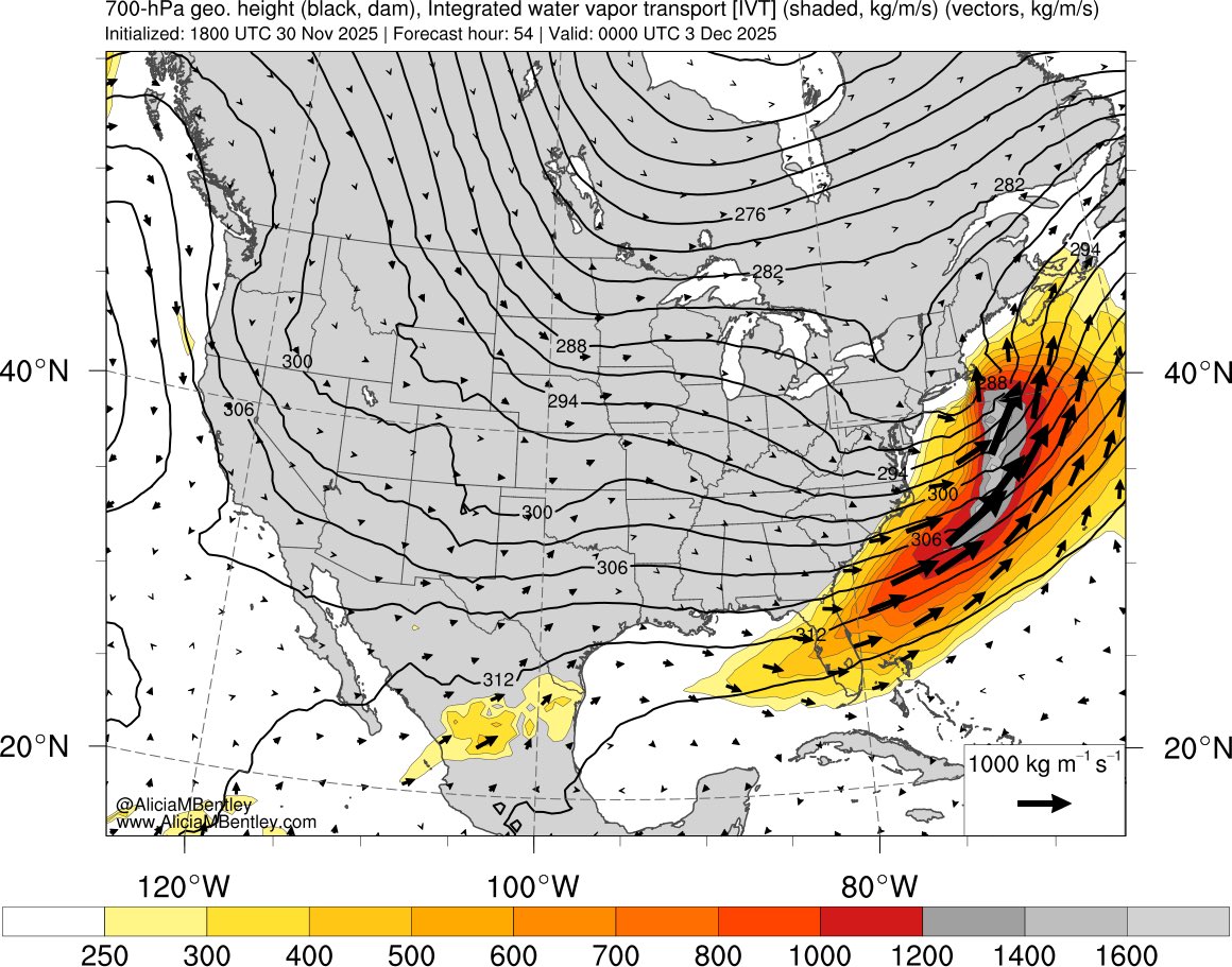
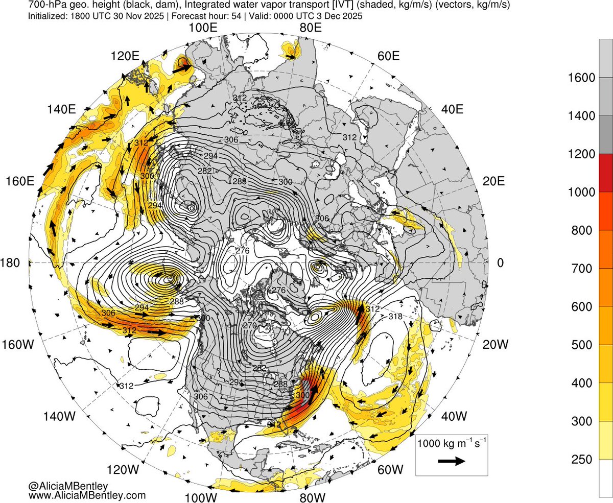
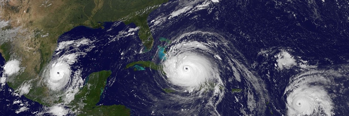
Katılım Aralık 2016
644 Takip Edilen460 Takipçiler
Evan Belkin
Evan Belkin@EvanBelkin·
@WXmarcus Trust you me that I am sure a CIG2 was considered. CIG2 is roughly a 12% of an EF3+ tornado, while CIG1 is 6%. It's possible the confidence just wasn't there.
English
0
0
1
139
Marcus
Marcus@WXmarcus·
@EvanBelkin Your right, and at the end of the day, that’s the only thing that matters. However, this was a big missed opportunity to have that extra layer of information out for people like broadcasters to relay.
English
1
0
1
1K
Marcus
Marcus@WXmarcus·
I think it’s important to acknowledge the failure by the NWS today. Two violent tornadoes in only a cig 1 in an environment that could’ve easily supported the cig 2+ is ridiculous.
English
37
15
461
47.6K
Evan Belkin
Evan Belkin@EvanBelkin·
@ColeWeather25 Congratulations, Cole! I am excited to welcome you to Albany in the fall!
English
0
0
1
60
Cole Stern
Cole Stern@ColeWeather25·
Super stoked to announce my commitment to studying atmospheric science at the University of Albany! Can’t wait to continue my academic journey and continue to pursue my passion in meteorology and research! See you in the state capital this fall 🫡
Cole Stern tweet media
English
4
0
13
550
Evan Belkin
Evan Belkin@EvanBelkin·
@krisbedka We've seen some evidence that the data got transmitted into the GFS, but can not say for sure 100%. I can tell you that the infrastructure is working is though. We released 9 dropsondes yesterday. Justin says to feel free to reach out to him with any other questions!
English
0
0
1
59
Kris Bedka
Kris Bedka@krisbedka·
@EvanBelkin How many dropsondes were released on yesterday's flight, and did they get transmitted so they could be assimilated by operational models?
English
1
0
1
45
Evan Belkin
Evan Belkin@EvanBelkin·
Very strong signal for impactful icing across much of the Northeast U.S. Locally, some of the highest impacts are forecast across the Adirondacks where the WSSI now has major impacts forecast. I wouldn't be surprised to see an Ice Storm Warning upgrade for the Adirondacks.
Evan Belkin tweet mediaEvan Belkin tweet media
English
0
1
7
896
Evan Belkin
Evan Belkin@EvanBelkin·
Another fascinating radar loop out of KBGM. One can see a clear distinction between the stratiform precip in central/eastern NY v.s. the convective precip farther south across eastern PA. 02z SPC mesoanalysis show elevated instability with pockets of MUCAPE > 100 J/kg across PA.
Evan Belkin tweet media
English
0
1
6
418
Evan Belkin
Evan Belkin@EvanBelkin·
Interesting find is that KBUF Radar is reminiscent of a summer time MCV, perhaps in response to the progressive upper-level shortwave located on the edge of the ridge, i.e, a "ridge roller"! Can clearly see the dry slot as well, which could cut totals somewhat south of I-90...
English
0
1
5
418
Evan Belkin
Evan Belkin@EvanBelkin·
@wxkaitlynj Good luck NYC.... I think it will be tough to beat 3" and looks like a lot of sleet...
English
0
0
2
160
Kaitlyn Jesmonth
Kaitlyn Jesmonth@wxkaitlynj·
Mix steadily making its way east in New Jersey
GIF
English
2
0
11
2.9K
Evan Belkin
Evan Belkin@EvanBelkin·
@P_SimmsWX Not only that but the RRFS really struggled with this storm. It was too far south for several runs!
English
0
0
0
96
Peyton Simmers
Peyton Simmers@P_SimmsWX·
The mixing line is steadily making progress northeast as the warm nose is moving fast. The NAM had the warm nose modeled best and it is the best model to use for them. It is sad to see the NAM go in a few months cause no other model is good at warm noses.
Peyton Simmers tweet mediaPeyton Simmers tweet media
English
4
1
38
7.5K
Evan Belkin
Evan Belkin@EvanBelkin·
@burgwx I like ensembles 27, 28, 34, 37, 39, and 50. Just sayin'!
English
1
0
1
74
Tomer Burg
Tomer Burg@burgwx·
Generally speaking, amplitude is on average tied to latitude: - stronger & more amplified system produces snow mostly north of NYC metro - moderate amplitude storm favors the NYC metro - weaker storm mostly stays south
Tomer Burg tweet media
English
2
0
5
2.8K
Tomer Burg
Tomer Burg@burgwx·
[Tuesday, 12/9] Quick forecast update re: this weekend: Re: Saturday - a model consensus is emerging for a shearing out vort max Fri night-Sat with snow weakening as it passes east of the Appalachians. Some light snow may still make it to - you guessed it - Virginia
Tomer Burg tweet mediaTomer Burg tweet mediaTomer Burg tweet media
Tomer Burg@burgwx

As of today, there is at least a non-negligible signal for two possible snow events in the NYC metro this weekend. This analysis will look into whether a miss to the south or the north is more likely, if one or both signals vanish, or if one or both could finally do the trick 🧵

English
1
2
24
31.3K
Evan Belkin
Evan Belkin@EvanBelkin·
@jaycordeira FWIW, the 00z HREF mean is still 6-8” for the Cap Region. Certainly a lot of spread though across the individual CAMs. Certainly doesn't look as good as it did this morning...
English
0
0
0
35
Jay Cordeira
Jay Cordeira@jaycordeira·
The developing Nor’easter on Tuesday will be fueled by the strongest atmospheric river in the Northern Hemisphere (really the whole globe; not shown). IVT magnitudes >1600 kg/ms are common to only the strongest ARs (and tropical cyclones).
Jay Cordeira tweet mediaJay Cordeira tweet media
English
1
1
14
906
Evan Belkin
Evan Belkin@EvanBelkin·
And no, I didn't include the eye candy run of the NAM :)
English
1
0
2
95
Evan Belkin
Evan Belkin@EvanBelkin·
It will be interesting to see how the Tues-Wed system ends up. IFS is the farthest southeast...
GIF
English
1
0
3
123
Evan Belkin
Evan Belkin@EvanBelkin·
@MikeMasco One needs to be very careful when analyzing this figure as the color bars are different for each NCEI plot. From a quick glance, some forecasts look quite poor, but are actually better than they appear!
English
0
0
3
282
Mike Masco
Mike Masco@MikeMasco·
🚨 CAREFUL OF BAD WINTER FORECASTS This is why I have ALWAYS had an issue with NOAA’s Winter Outlook.. below is a look between their forecast and what actually verified! The NOAA seasonal outlook is based purely on the state of the pacific which I don’t need to tell you is not the ONLY thing that can wildly impact a seasonal forecast. Should I put out a winter outlook? Hmmm
Mike Masco tweet media
English
21
24
159
40.7K
Evan Belkin retweetledi
NWS Bay Area 🌉
NWS Bay Area 🌉@NWSBayArea·
With 0.08" of precipitation, San Francisco had the 8th wettest July on record (since 1849). Other NWS offices may find this funny.
English
50
209
2.4K
241K
Evan Belkin
Evan Belkin@EvanBelkin·
@NickPBassill @accuweather Hmmm....I can only wonder where the models that AccuWeather used to predict the disastrous flooding came from 🤔🤔🤔
English
0
0
3
140
Nick P Bassill
Nick P Bassill@NickPBassill·
This is really gross stuff by @accuweather - especially given what's occurring at NOAA/NWS right now. It would be one thing if this was all true ... but it's just obviously not. Claiming they were the "only" one to predict disasterous flooding from Helene? Woof.
Nick P Bassill tweet media
English
6
9
88
7K