Kris Bedka
2.3K posts

Kris Bedka
@krisbedka
Research Scientist, @NASA_Langley, Weather/Climate Science, especially convection, mesoscale processes, and Doppler wind lidar. All views are my own
Hampton, VA Katılım Nisan 2017
228 Takip Edilen574 Takipçiler

This is one of the wilder satellite animations I've seen in a minute...
Wildfires produce their own thunderstorms while smoke wraps around a low pressure.
What a fascinating view out of southern Kansas this evening.
English
@CollinGrossWx The elevate cirrus plume streaming out of the bubbling area is the strongest indicator of this storm's severity
English

Visible satellite loop showing the bubbling cloud tops of a supercell that just missed Fort Worth, Texas to the southwest tonight.
This storm produced a tornado in Mineral Wells and up to softball size hail. #TXwx
English
It is great to see the DCOTSS field campaign overview paper published in BAMS. This campaign was one of the most fun I have worked on in my career. Great leadership, team, and science! journals.ametsoc.org/view/journals/…
English
Kris Bedka retweetledi

This week’s East Coast winter storm met the definition of a bomb cyclone, meaning its central pressure dropped at least 24 millibars in 24 hours, signaling rapid intensification. 🌀 Our Tempest network captured intense 3-hour sea-level pressure changes as the system deepened.
English
@EFisherWX That's really cool, there are really interesting mesoscale features like this that impact the weather throughout the world. You just have to know where to look. I like the river effect storms from the James River that occur on calm wind days over Newport News and Smithfield VA
English

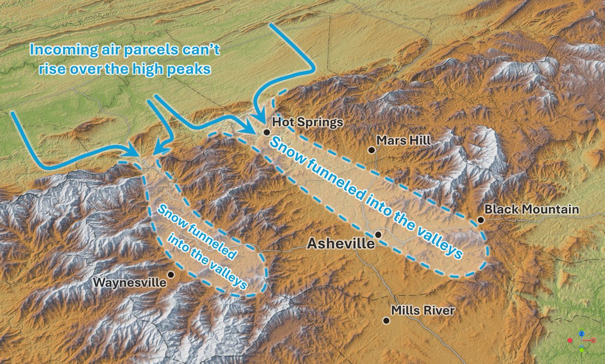
I've really come to love northwest flow events like the one we'll see tonight.
Watching how the terrain funnels snow into Haywood and Buncombe County is simply amazing.
English
@JLaDue @VORTEXJeff I've seen some really nasty looking cells in satellite images along the Gulf Stream. You could crop the image of them and put it over the Midwest and I'd believe you.
English

How many of these tornadoes are occurring over and east of the Gulf Stream with wintertime Nor’easters?
Weather Monitor@WeatherMonitors
The video captures an impressive waterspout seen today from the deck of a container ship in the Bermuda Triangle.
English
Kris Bedka retweetledi

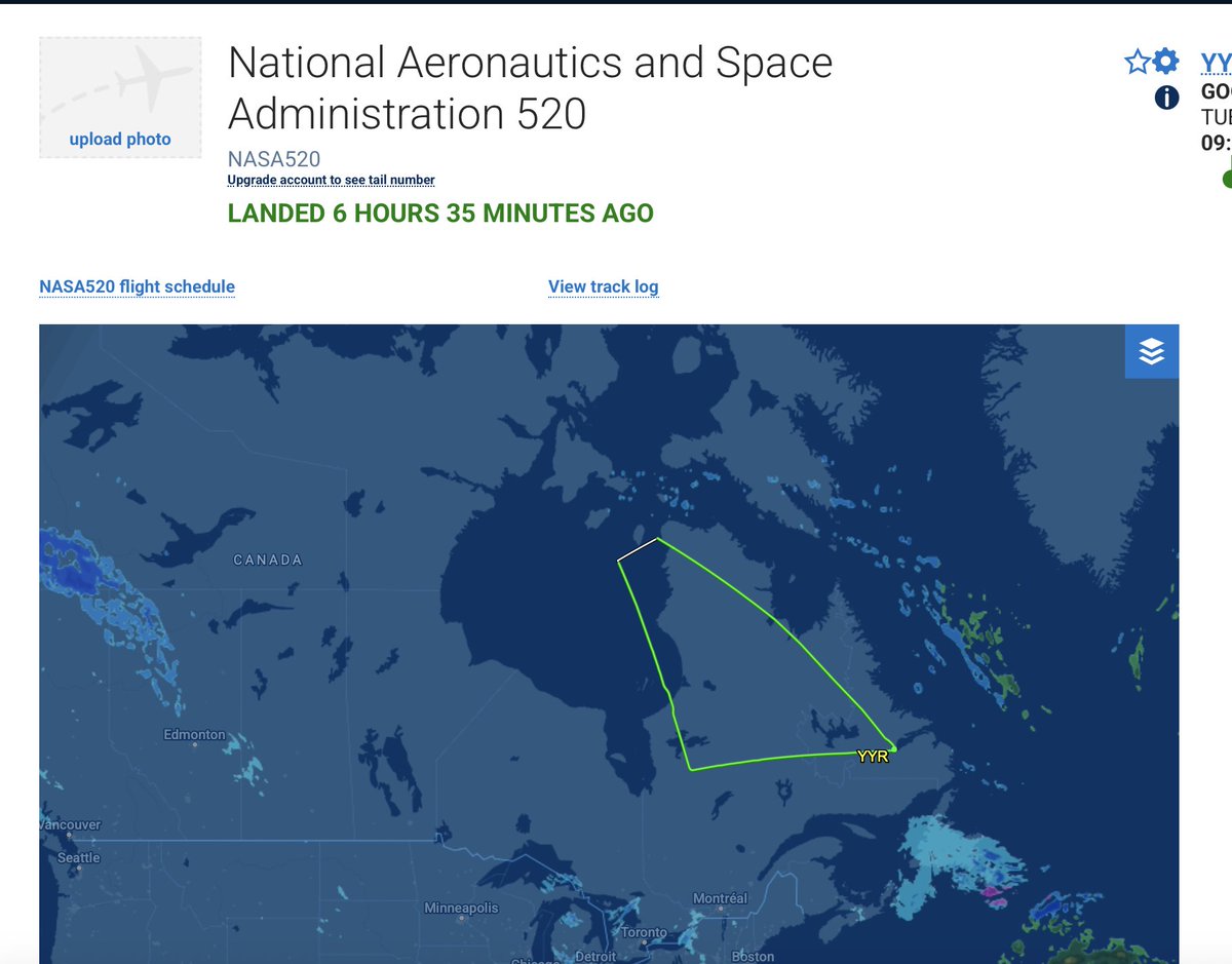
A @NASA research aircraft is helping to improve the models that feed storm forecasts 🌨️
The international mission, called NURTURE, will measure moisture, clouds, and ozone as winter storms develop to better understand severe winter weather. go.nasa.gov/45w5uKE

English
@EvanBelkin How many dropsondes were released on yesterday's flight, and did they get transmitted so they could be assimilated by operational models?
English

Proud to be forecasting for the NASA NURTURE Field Campaign, helping plan daily flight missions. The data we collect isn’t just for future research; it’s fed directly into weather models to improve forecasts, including this weekend’s potential winter storm!

GIF
Tomer Burg@burgwx
Following up from my discussion yesterday, the biggest uncertainty is in the exact evolution of the TPV emerging out of Canada: - how quickly does the TPV become negatively tilted? - how far south/west does this occur? Broadly speaking, scenarios range from the following: Scenario 1: More progressive and weaker TPV digs into the SE US and only becomes negatively tilted offshore, with a minor-moderate snow event over the Carolinas & heavy snow well offshore Scenario 2: TPV is stronger and farther west, becoming negatively tilted over the SE US & forcing rapid cyclogenesis just off the Carolinas, with a major Carolinas/VA snowstorm and moderate snow farther up the coast as the decaying post-occlusion low tracks northeast Scenario 3: TPV is even stronger and farther west, with the latitude of negative tilt shifted a bit north, favoring a major coastal snowstorm up to Maine primarily south/east of I-95 but possibly including the big cities
English
Kris Bedka retweetledi
NASA’s first Earth-observing satellite was TIROS-1, which monitored cloud cover and weather patterns.
Now, @NASA operates more than 20 satellites that study Earth’s land, water, air, and climate, helping us learn more about this planet we call home. 🌎
English


@messycarroll I went to one of said Catholic schools, went to NIU, then went to grad school, and now I work for NASA. Does this make me a degenerate too?
English

So this area produces Catholic school kids that grow up to be degenerates, choose between Illinois, Illinois state or Iowa for college, then come back, get a real good job and send their kids through the same cycle. Don’t disrespect MY culture again🫵
New town every hour (ret.)@TownsUsa
what goes on here?
English


@CourtneyRCronin Now they all need to actually play in a game together...
English

Jaquan Brisker believes the energy/trash talk he, Tyrique Stevenson and now C.J. Gardner-Johnson will bring to the Bears secondary is an advantage: "Especially the way I talk and the way other people talk. We get people's heads. Grown men will be really crying out there. Men with kids. Imagine that. Seriously. It's hilarious. I wish I mic'd up every game."
English
@weatherdak I wonder how the variation of cloud height throughout the column of the eye and the resulting variable displacement of the cloud position due to parallax affects our perception of the sloping of the eyewall
English
Kris Bedka retweetledi
Alrighty, ready to see something really cool?
The evolution of Hurricane Melissa's mesovortices at peak strength.
English
@CameronJNixon @VORTEXJeff Sorry I should have said tracks instead of swaths
English

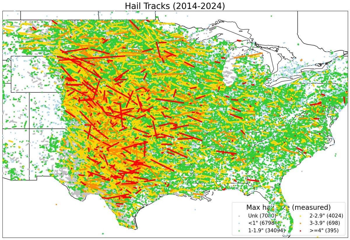
Some insights:
- High Plains are king (but things tame a bit near the mountains)
- Southeast struggles with swaths
- northwest flow is king (most noteworthy hail tracks move NW-to-SE, unlike tornadoes)
- still some significant reporting gaps (esp. SE NM into SW TX)
English
Here it is. The last 10 years of hail events across the U.S. using my prototype hail tracking algorithm!
Hoping to build out a more robust climatology of hailstorms like we have for tornadoes.
GIF
English
@CameronJNixon @VORTEXJeff Is this dataset available? It would be extremely useful for determining hailstorm detectability and severity estimates using satellite data. swaths are much more amenable for satellite comparisons than individual reports. I assume you interpolate b/t reports to get a swath?
English
Kris Bedka retweetledi
Due to the Hunga eruption in 2022, the stratosphere became intensely hydrated. Now, it is dehydrating much more slowly than expected. The stratosphere may remain abnormally humid for an extended period, prolonging the climate effects of the volcano.
agupubs.onlinelibrary.wiley.com/doi/full/10.10…

English
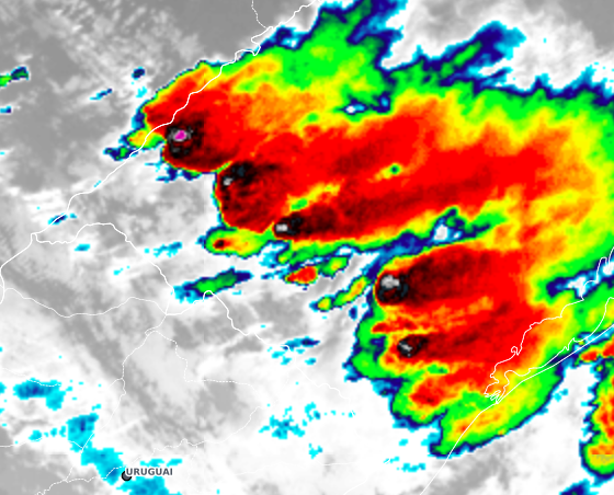
@BrunoZRibeiro @GoedeTDS Those overshoots are so wide and prominent in temperature relative to the anvil, especially the northern one. I assume that one was the most severe?
English
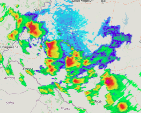
Remarkable line of supercells in Rio Grande do Sul, southern Brazil. The environment is extreme in terms of CAPE x shear combination for this region, with >3500 J/kg CAPE and effective shear > 50 kt
English
@wxrjm Looks like Hampton will be missed by just a little bit by the heaviest bands. We could use a good soaking rain.The southern part of Hampton has been getting missed repeatedly by rains since August. This 0.6 inches we got from the recent rain was so badly needed but we need more
English
Clear signal for heavy rain somewhere in SE VA/ NE NC. Somewhere may get stuck under a heavy training band and end up with some flash flooding.
Areas just NE of the low will have the best chance. Thinking areas near the NC/VA border and into Eliz City/SW into Gates.
GIF
English