Garden State Weather retweetledi
Garden State Weather
40.1K posts

Garden State Weather
@GardenStateWea
Forecasting For The Northern Mid Atlantic Region
Northeast NJ Katılım Temmuz 2011
698 Takip Edilen605 Takipçiler

HRRR more in line with NAM for snow changing to sleet by 2pm for Toms River area, HRRR had it holding off until 4pm previously. Drops 3/4-6” before sleet at 10:1 for SNJ, so a bit more due to onset high ratio #NJwx

English
Garden State Weather retweetledi

If you Want Snow: THIS IS LOOKING BETTER
📣 This is the UPDATED European Model following the GFS in my prior post.
👍 The Big News Here: AGREEMENT!
💪 THIS IS NOW CLOSER WITH MODERATE SNOW - AND-STRONGER Than The GFS!
🚫 Friday: NOT the main event. Not much to see there now.
✅ Sunday Morning: THE MAIN EVENT
❄️ This is our SNOW DAY!
💻 ECMWF Model View
⏰ 7 AM Sunday: MODERATE SNOW
👉 THIS ALSO Looks like a jet streak pulsing a Lee side trough East of the Mountains.
🌡️ Temps closer to freezing, but support for a snow event. Colder air aloft will help even if surface temps are marginal.
📏❄️ Snow Potential for A FEW INCHES. Tomorrow we enter the window of comfort for legitimate numbers.
🐻❄️ The Polar Vortex will follow will VEYR COLD AIR.
🌀 The Trough Axis shows a "Positive Tilt", which is a faster mover... but the orientation supports snow to reach up the coast into Southern New England as it pivots through.
>L< Low Pressure in this scenario will develop rapidly off the coast to allow the enhancement.
‼️ This is NOT set in stone.
What like here is the similar product from the ECMWF and GFS after the recent variants.
⏰ We are in a 4-day window, making this more viable. ALSO, the attention for you planning: More attention away from the first clipper Friday and on to this.
👀 Stay tuned. I will update the Western Maryland Blizzard in a bit.
#mdwx
#snow
#FITF


English
Garden State Weather retweetledi

❄️ GLOBAL MODELS CATCHING ON TO SUNDAY SNOW POTENTIAL…
The GFS — which previously had a “much ado about nothing” type setup for Saturday night into Sunday — is now coming around on accumulating snow. The EURO is also coming in much juicier with this system.
📊 Below are the last 3 GFS runs, all showing an accumulating snow scenario very much in play.
📝 Latest thoughts here:
pix11.com/news/local-new…
GIF
English
Garden State Weather retweetledi

Reminding myself to never get too excited too soon, but an event poss coming together within 3-4 days ;) #NJwx


English
Garden State Weather retweetledi

It wont be as cold as it is now, but the northeast will most likely not get any long duration warmth.


Will Ciccone@weatherwilly
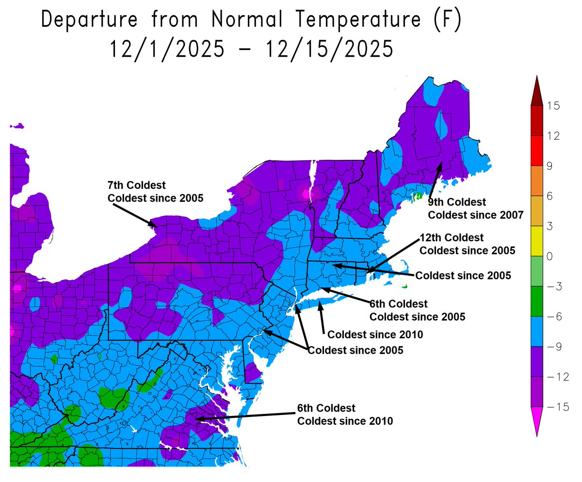
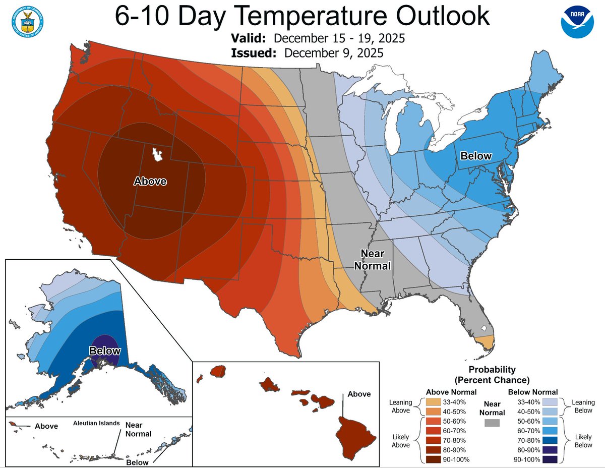
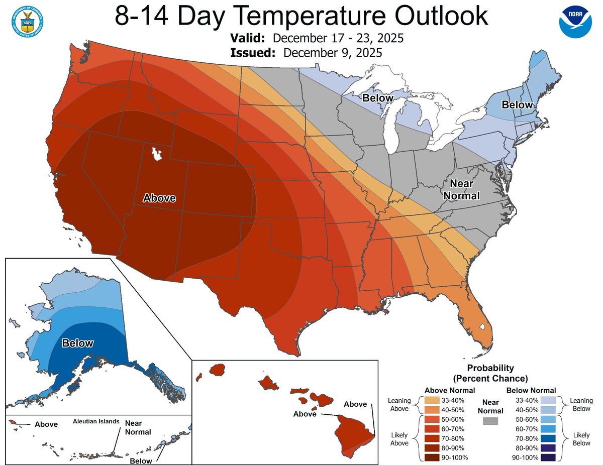
This is just a mean. Its not what the end pattern will look like as this period approaches. Ridges and troughs are washed out. Looking deeper into the individual ensemble members you can see warm vs cold clusters. The average in between leads you nowhere imho.
English
Garden State Weather retweetledi

Here is the fundamental problem with social media weather. Some of you overreact to some long-range model data and go to the extreme, either expecting a cold pattern with 50 blizzards or 60s and rain all winter because of a single run or two.
What you guys don't do is ask a fundamental question: WHY is the model showing what it is showing? Now, many of you can't because you don't have the education yet. So, let me provide something to ponder. Considering the weather pattern we are in now, what atmospheric factors would cause the cold weather pattern we are in now to fundamentally change? When you can answer that question, then you won't need to overreact to every model solution that comes along every six hours.
English
Garden State Weather retweetledi

Wild look at cold anomalies the next several days. Purple is cold. Pink is real real cold. Couple blobs dipping and clipping the US back to back. Warmer temps are staying on the western side for awhile. And look at Alaska. Some real cold air sticks around there. Negative double digits towards Christmas. Brrrrr. spaghettimodels.com
Charlotte, NC 🇺🇸 English
Garden State Weather retweetledi

12z Data is rolling in...
I have my eyes on these 3 areas:
Area 1: A combination of strong Frontogenesis, orographic wind alignment, and high Snow to Liquid ratios will produce over 1 foot of snow on Southerly Facing Slopes,
Area 2: Deep Cold Air and good dynamics keep it all snow. Confidently Plowable Totals.
Area 3: Surprise! This is where the battle zone between snow and a mix is. If you stay all snow here, you could end up with some surprisingly high totals for a weak storm system. Laporte will likely get buried while Mount Pocono mixes back and forth between snow and sleet
~Meteorologist Mark Margavage
#wxtwitter #wxX #PAwx #NYwx #snow

English


