

Maina Mfalme
201 posts



Maina Mfalme retweetledi


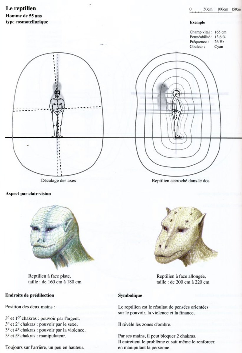
A French clairvoyant, Stéphane Cardinaux, saw reptilian beings shadow and attach themselves to people's astral bodies. They apparently extend their own lifespan by feeding on negative emotion, which makes them denser. They inspire thoughts and block life force, like heart energy.

English

Hii ndio msema kweli when it comes to long range ensemble forecasts. And it rarely gets it wrong.
Maithya wa Vilivū@MaithyaVilivu
The multi-model super ensemble precipitation anomalies charts depict a large pool of warmer-than-usual pool waters, intense atmospheric convective activity, near-zero upwelling courtesy of strong easterly winds off the coast of Eastern Africa by September 2026. The exact opposite (drier-than-normal conditions) is in the offing for the Eastern Indian Ocean adjacent to the Maritime including Malaysia & Singapore. This looks like a replica of the prevoius 2023 OND rainy season that coincided with a strong El Nino & a strong IOD, bringing record-breaking rains to North Eastern, Eastern & the coast and very heavy MAM 2024 rains in the rest of #Kenya. We wait and see what May 2026 model run outcomes have for us.
English
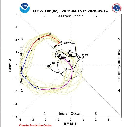
@MaithyaVilivu The re-analysis line is the one showing the current position of the MJO?
English
Global models show a high amplitude MJO index entering The Western hemisphere and Africa as well as phase 1 & 2 in the coming days, after lingering in the Pacific Ocean for almost a month.
Australian and Japanese Met models show a high amplitude MJO wave in equatorial Africa in the last week of April into early May.
100-member ECMWF and NOAA CPC's models show a high amplitude MJO eastward pulse in phases 1,2 & 3.
The MJO wave is expected to bring increased atmospheric convection, humidity and cloud formation coupled with the ITCZ hence the improved precipitation performance in eastern Africa


English
The peak of the MAM rainy season in #Kenya normally occurs in the last two weeks of April.
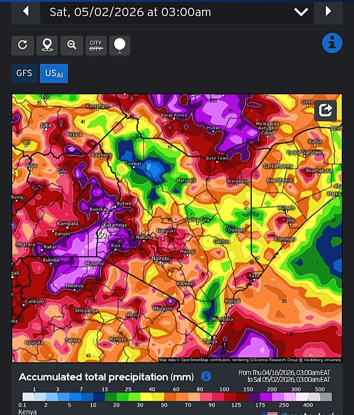
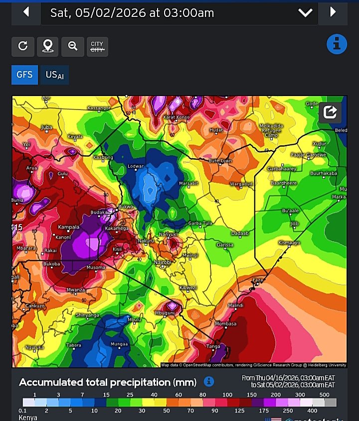
As we enter the second half of the month, medium range weather forecasting models output graphics depict heavy to very heavy rains in most Counties of #Kenya within the two weeks ending 02/05.
GFS ECMWF and the US-AI are in concurrence that heavy rains (up to 350mm in some places) may fall in Western, Nyanza and parts of Central Rift valley within the forecast period. This points to a high likelihood of disruptive rainstorms in these areas.
Central, #Nairobi, Mt Kenya massif, North Eastern, the Coast and Ukambani regions receive moderate to heavy rains in the same period.

Maithya wa Vilivū@MaithyaVilivu
Update: The skill-weighted NMME multimodel-ensemble charts depict slightly-to-highly enhanced rainfall across most of #Kenya in the last ten or so days of April. Between 36%-70% of model simulation observations for KE in that forecast period lie in the upper tercile, indicating wetter-than-normal conditions may prevail. Further updates in the coming days
English
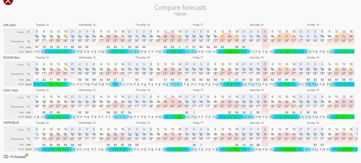
The ongoing cool showery weather conditions in #Nairobi Metropolitan area of #Kenya may persist into the weekend, per short range forecast model charts. Max daytime temps at 3PM may not exceed 26⁰C the whole of this week, with a July-like feel.
Substantial rainfall is likely to fall in higher ground areas of Kiambu & Murang'a Counties.
Next weekend from around Friday 24/04, moderate to heavy rains may return to Nairobi County
English
Tropical storm Indusa dissipated in the Southern Indian Ocean last week. In its aftermath, laminar flow of south easterly winds has resumed in earnest, blowing strongly all the way from the West Coast of #Australia to the Tanzanian shoreline, thanks to a developing depression off the coast of TZ.
These moisture-laden winds are actively coverging with northerlies from the Mozambique Channel, bringing heavy rains to the South & East of TZ.
Models show that these rains will be heavy with some places recording close to 500mm in two weeks.

Maithya wa Vilivū@MaithyaVilivu
Trpical storm #Indusa gains strength, continues with it's southward trajectory in the Southern Indian Ocean. It is expected to dissipate into the higher latitude regions of the Indian Ocean early next week, per model projections. This storm has caused severe disruption of south easterly and easterly winds, leaving most of the horn of Africa including many parts of #Kenya staring at a dry spell in the middle of the rainy season.
English
Maina Mfalme retweetledi

@TheProjectUnity Most humans can't even fathom what you're referring to.
English
@tii_bag Read a book titled "Flying Serpents and Dragons" by R.A Boulay. Be open minded when you read it, it may offer you an explanation.
English

@hudumaManda Yes it can, but why would it? It can do this the same way a scientific calculator can do differentiation and integration, does it mean you don't study calculus?
English

AI can do this for you in less that a second
Akash@kaaaash____
I’m 22 and I want to start learning DSA now. Be honest… am I already late?
English
@FourthArchetype There is a book titled "Gods of Eden " by William Bramley. He says all of these apocalyptic religions are made up so as to lead people away from true spiritual knowledge. It is a good read if you are interested.
English

Nothing strikes me as more dubious than Abrahamic eschatology. People have been fretting about the “end times/apocalypse” for over a millennium, and centuries from now they will likely still be talking about messiahs and mahdis, so long as Christianity, Judaism, and Islam endure.
English
Maina Mfalme retweetledi
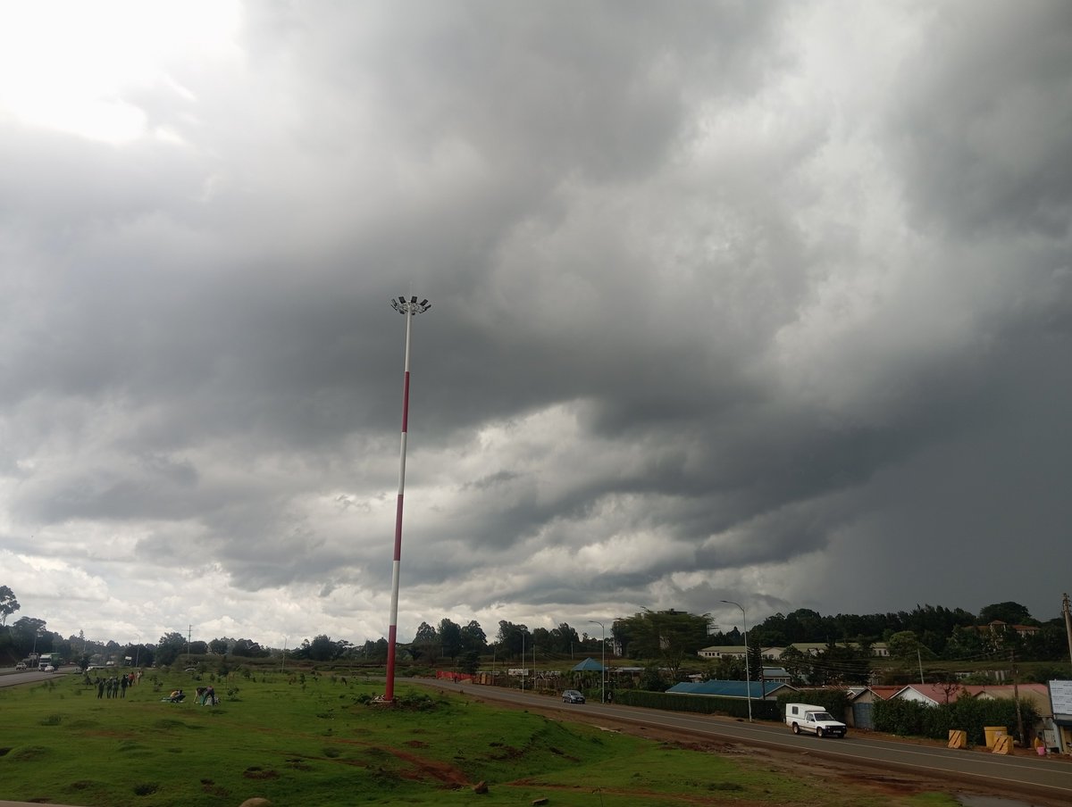
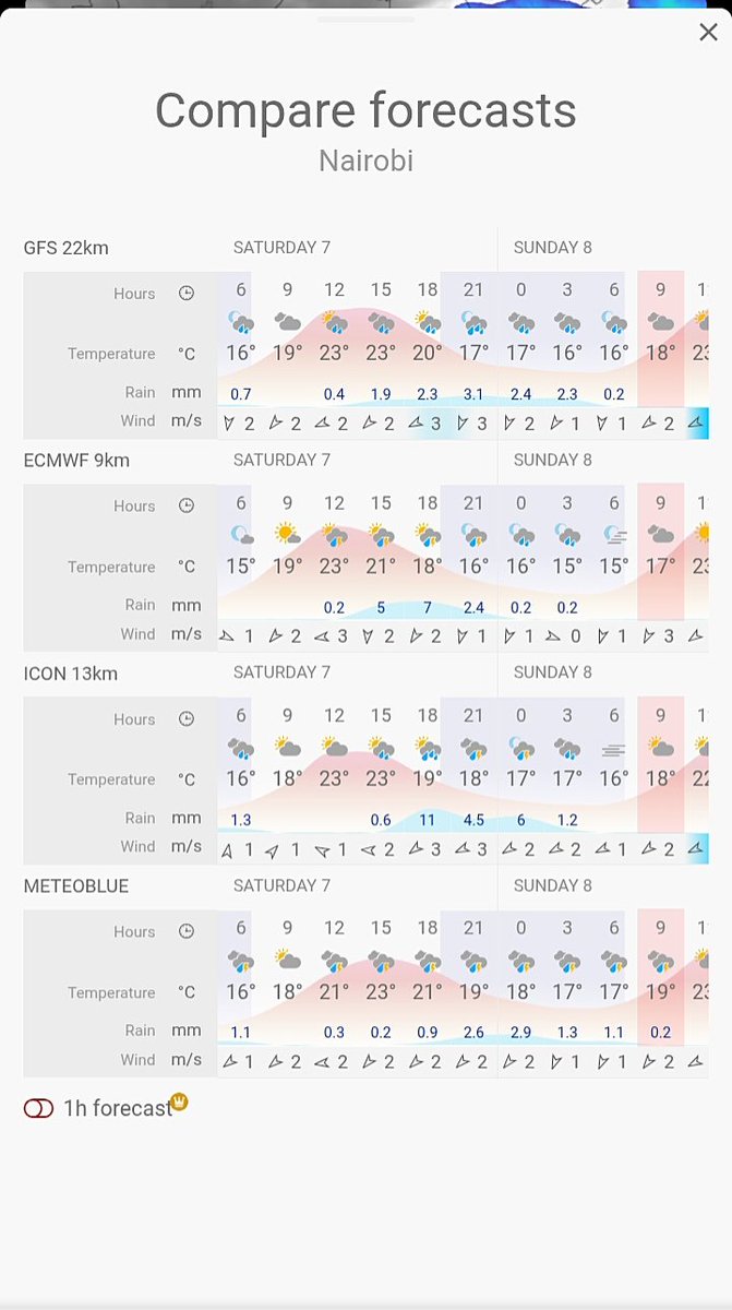
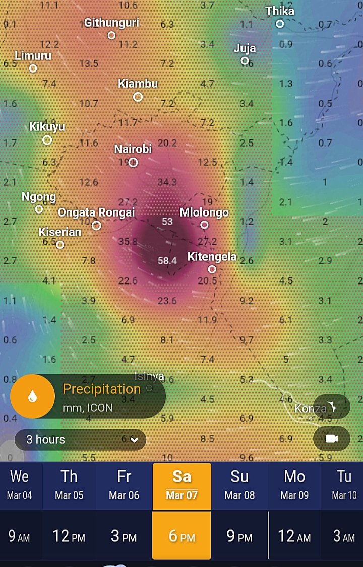
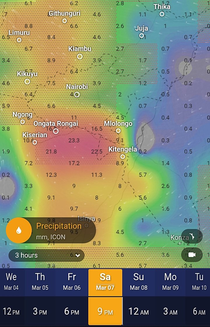
Saturday #weather forecast update, #Nairobi #Kenya: We expect the last wave of moderate to heavy rains in Nrb metro area this evening. Short range forecast charts by major models concur in this regard.
From tomorrow into next week, rains subside significantly in the city
Maithya wa Vilivū@MaithyaVilivu
⚠️Updated weather forecast for #Nairobi metropolitan area tonight looks scary 😲 Machakos, Nairobi & Murang'a folks take all necessary measures to stay safe
English
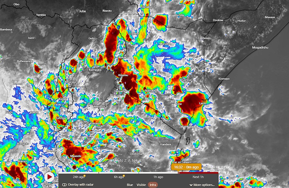
1632 Hrs EAT: Satellite images show intense atmospheric convection all over #Kenya as moisture-laden south easterlies, easterlies from the Indian Ocean converge with Congo air mass westerlies. Heavy rains expected in most counties starting today through saturday.
English
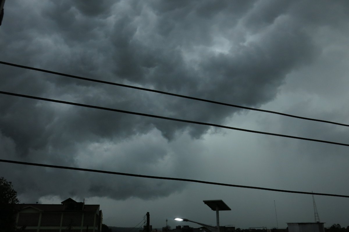

🚨 Heavy Rains Update – Kenya 🌧️
Advisory No. 02/2026 active until 9th March! Peak rains hitting hard right now (4th–7th March) across Lake Victoria Basin, Western, Central Highlands including Nairobi, SE Lowlands & Coast.
Quick poll – how’s it looking where you are?
React below 👇
🌧️ Heavy rain right now
☔ Light/moderate showers
☀️ Dry/clear
⚠️ Already seeing floods
Plus: Share a quick photo of the rain/flooding in your area!
Reply with pic + your county (e.g., Kisumu, Mombasa, Nakuru, Eldoret, Mandera, Nyeri, Machakos). Safe spots only – no risks!
Stay alert & avoid flooded roads/moving water ❌
Full details: meteo.go.ke
#HeavyRainfallAdvisory #KenyaRains #KMD #ShareYourRain 🇰🇪🌧️
Kenya Met Department 🇰🇪@MeteoKenya
🚨 HEAVY RAINFALL ADVISORY No. 02/2026 🌧️ Issued: 3 Mar 2026 4pm | Valid: 3 Mar (6pm) – 9 Mar (7pm) 2026 Heavy rain >20mm/24hrs continues, peaking 4th–7th Mar. Persists longest in Lake Victoria Basin, Western Kenya, parts of Central Highlands including Nairobi, SE Lowlands & Coast. Counties affected: Turkana to Kwale & many more (full list in advisory). ⚠️ Risks: Floods, flash floods, poor visibility, rising rivers. ❌ Avoid flooded roads/moving water ❌ No shelter under trees in storms Stay alert! Full details: meteo.go.ke 👀 Stay updated via official KMD platforms: 🌐 meteo.go.ke 📥 Daily Forecast: meteo.go.ke/our-products/d… 📥 7-Day Forecast: meteo.go.ke/our-products/7… 📥 County Forecasts: meteo.go.ke/our-products/c… 📲 WhatsApp: whatsapp.com/channel/0029Va… 🐦 x.com/MeteoKenya 📘 fb.com/KenyaMeteorolo… 📸 instagram.com/MeteoKenya #HeavyRainfallAdvisory #KenyaWeather #RainfallUpdate #KMD #StayInformed 🌧️
English
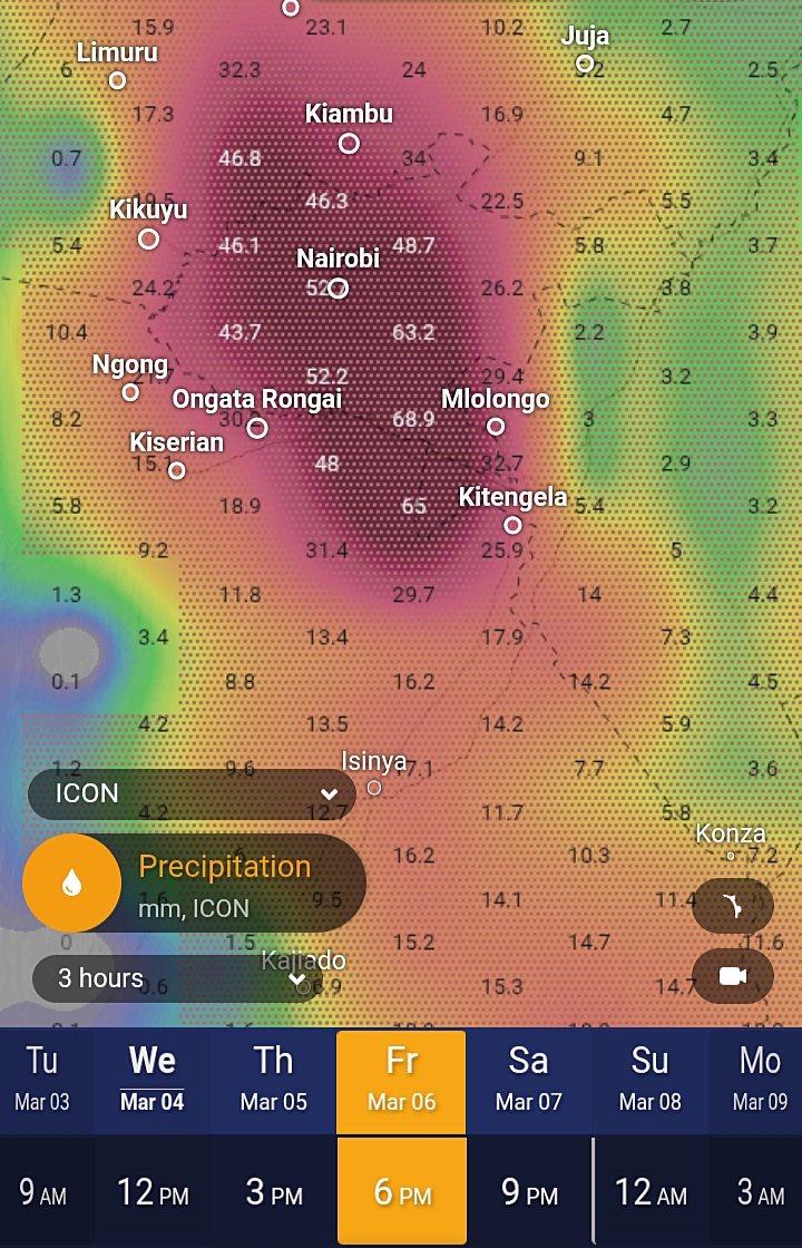
#Weather update for #Nairobi #Kenya and it's outskirts:
⚠️Very heavy rainfall expected on Friday 06/03 from the afternoon into the night per DWD ICON model. Flash flooding possible over the weekend

Maithya wa Vilivū@MaithyaVilivu
March Week 1 weather outlook: The skill-weighted consolidated multimodel ensemble charts show that most of the simulated weather scenarios lie in the >67th percentile, projecting wetter-than normal conditions conditions for over 90% of Kenya, spare for a few parts of NE & Turkana
English
@MaithyaVilivu The MJO is no longer in the phases 2 and 3, is this the Congo airmass contributing to this?
English
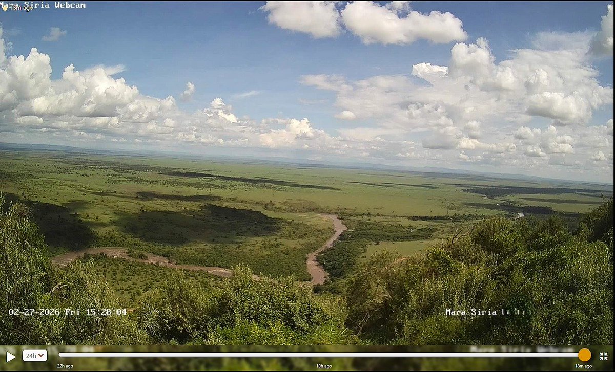
Current views from the Maasai Mara before the storm in the coming days.
Maithya wa Vilivū@MaithyaVilivu
⚠️⚠️ NAROK County folks brace yourselves for the deluge that's coming in the next 7 to 14 days. Disruptive rains on the way, per GFS model.
English
1355 Hrs EAT: Satellite images show a warm front propagation over #Kenya, moving in a West to East direction, affirming earlier medium range forecasts. Can you see it?
A clear indication that the weather is about to change immensely in the coming days, starting today.

Maithya wa Vilivū@MaithyaVilivu
Preliminary showers have been falling in #Nairobi since last weekend. Tomorrow evening & Wednesday a heavy downpour is expected in the city & its environs Uncharacteristically heavy rains are expected in multiple Counties of #Kenya in the last 7 days of Feb & the 1st week of Mar
English
I just published The song of a lifetime medium.com/p/the-song-of-…
English
@amerix - Diploma in Electrical and electronics (Knec)
- Experienced in fibre optic cable installation, maintenance and splicing (3 yrs)
- B2 drivers license holder.
English

@MeteoKenya What drove the occurrence of the rains for the last few days?
English
🌧️⏳ Rains to subside in Nairobi & its environs starting Friday ☀️🌤️
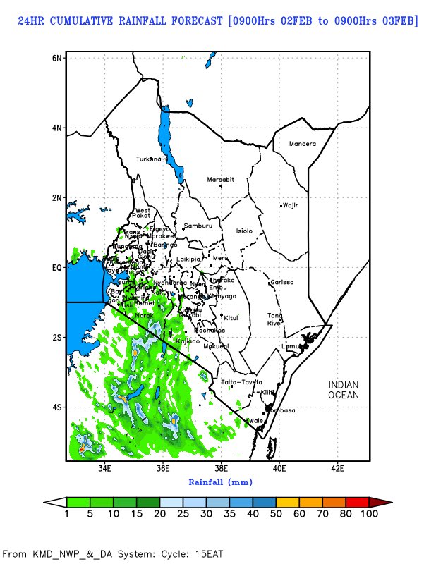
The Kenya Meteorological Department forecasts a reduction in rainfall over Nairobi and surrounding areas beginning Friday, with drier conditions expected to follow. See daily forecast maps illustrating changes.
🔗 Read more: kbc.co.ke/weatherman-rai… via @KBC
#WeatherUpdate #KenyaWeather
@KBCChannel1



English