NASA Earth

24.9K posts

NASA Earth banner
NASA Earth

NASA Earth

@NASAEarth

NASA’s favorite (habitable) planet. 🌎💚 Studying Earth from ground to orbit.

Earth Katılım Mart 2009
86 Takip Edilen3.7M Takipçiler
NASA Earth
NASA Earth@NASAEarth·
@NASA @isro Most of the displacement moved land east and west because the earthquake occurred on a strike-slip fault. The fault rupture propagated offshore to the east and onshore near the Caracas airport. Much of the worst destruction was near the fault rupture. go.nasa.gov/3QR8fC9
English
1
12
38
8.5K
NASA Earth
NASA Earth@NASAEarth·
This map uses data from the @nasa-@isro NISAR satellite captured before and after the quakes. Red areas show where the ground moved east and up; blue areas moved west and down. The darker the color, the more displacement. White areas indicate little or no displacement.
NASA Earth tweet media
English
2
14
56
9.3K
NASA Earth
NASA Earth@NASAEarth·
Two powerful earthquakes struck northern Venezuela on June 24, 2026. Satellite-based maps of ground displacement reveal how the land surface moved, providing insight into the forces behind the severe destruction. Let’s take a closer look at the map 👇
NASA Earth tweet media
English
7
77
233
33.4K
NASA Earth
NASA Earth@NASAEarth·
This small satellite is helping make GPS systems more precise. 🛰️ The satellite, called GRITTS, connects three different ways of mapping Earth, which will improve the accuracy of everything from changing ice sheets to shifting plate tectonics. go.nasa.gov/4h7br77
NASA Earth tweet media
English
14
33
153
21.7K
NASA Earth
NASA Earth@NASAEarth·
To study sea ice thickness, more than one view can help. NASA scientists spent two weeks flying above the Arctic with cutting-edge sensors aboard. When combined with satellite and on-the-ground measurements, the data helps us better understand how the region is changing.
English
6
83
362
64.5K
NASA Earth
NASA Earth@NASAEarth·
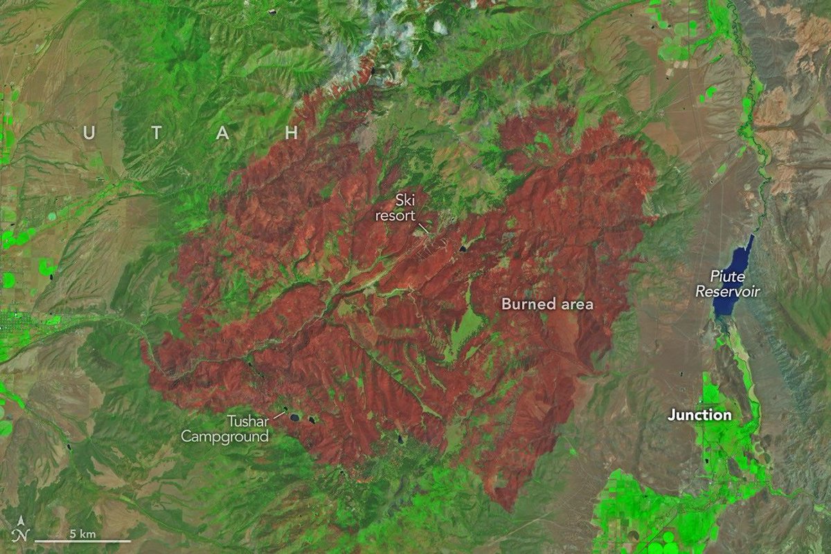
As the fire spread, NASA’s Fire Events Data Suite (FEDS) tracked its progression and growth rate, including its rapid spread from June 23 to 26. FEDS is one of several tools @NASA provides to firefighters and emergency management officials. go.nasa.gov/44iBSPO
English
1
7
39
8.1K
NASA Earth
NASA Earth@NASAEarth·
The Cottonwood Fire in Utah is one of the state’s—and the country's—largest and most destructive fires of the year so far. This false-color satellite image from Landsat 9 shows the extent of the burned area (shown in red) as of June 29, 2026.
NASA Earth tweet media
English
3
20
142
19.6K
NASA Earth
NASA Earth@NASAEarth·
Fire is a fundamental force of change 🔥 The PACE satellite views all of Earth daily, helping scientists to better understand wildfires. From monitoring vegetation health, to determining potential precursors, to tracking where the smoke travels after, PACE is up to the task.
NASA Earth tweet mediaNASA Earth tweet media
English
12
49
307
25.5K
NASA Earth retweetledi
NASA Science
NASA Science@NASAScience_·
To explore farther into the universe, we also have to understand our home. 🌎 With more than 20 satellites, NASA tracks Earth’s land, ocean, ice, and atmosphere to help communities thrive. This unique view from space serves all life below. go.nasa.gov/4axfEgp
NASA Science tweet media
English
21
94
547
33.2K
NASA Earth retweetledi
International Space Station
International Space Station@Space_Station·
The International Space Station orbited over Los Angeles on July 4th as America marked 250 years of independence with a burst of fireworks lighting up the city below — a celebration so bright it reached all the way to space!
English
201
2.3K
12.8K
860.9K
Mike Persampire
Mike Persampire@mikepersampire·
@NASAEarth @USGS @NASA Assuming conditions are present for the blooms to occur is there anything that could be done to prevent it or lessen the severity of a bloom? Also, Just fyi, I think you meant to mention @USGS and @NatlParkService
English
1
0
0
27
NASA Earth
NASA Earth@NASAEarth·
Algae blooms are more common in Colorado’s Blue Mesa Reservoir when water levels are low and water temperatures are high – conditions the area is currently experiencing in 2026, though no blooms have been reported.
NASA Earth tweet media
English
6
32
168
21.1K
NASA Earth retweetledi
NASA
NASA@NASA·
Happy 250th, America! 🇺🇸 Red (Mars), white (Moon), and blue (Earth) brought to you by the solar system.
NASA tweet mediaNASA tweet mediaNASA tweet media
English
653
4.4K
27.8K
1.8M
NASA Earth
NASA Earth@NASAEarth·
What’s going on here? 🤔 The poles are the only places ICESat-2 can’t gather data. Instead, the satellite’s orbit is designed so that it can better study the edges of the polar ice sheets and sea ice, where much of the change is happening.
English
15
69
334
36.1K
NASA Earth
NASA Earth@NASAEarth·
@CDCgov The work builds on 20+ years of collaboration between NASA and the CDC. The partnership illustrates how NASA shares information freely and openly to the public, as well as agencies and industries around the nation. go.nasa.gov/4wlhdq3
English
2
7
20
8.6K
NASA Earth
NASA Earth@NASAEarth·
Goooal! ⚽ During the #FIFAWorldCup, NASA air quality data is helping @CDCgov and its partners better understand the air that soccer players, fans, and nearby communities are breathing during the 2026 games.
NASA Earth tweet media
English
6
36
145
26.2K
NASA Earth
NASA Earth@NASAEarth·
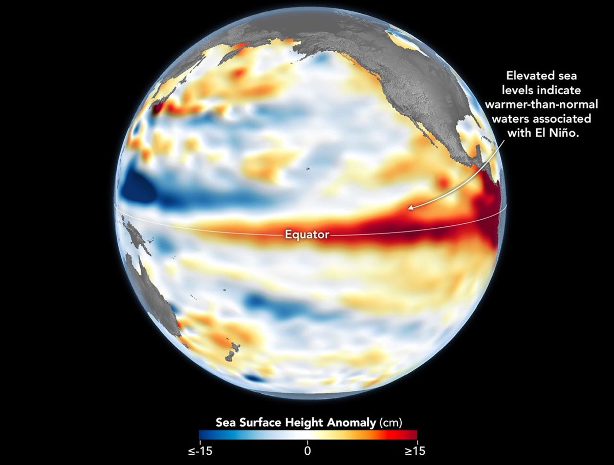
@NOAA Observations of sea surface height from the Sentinel-6 Michael Freilich satellite in June indicate that the 2026 event was continuing to strengthen. More: go.nasa.gov/3QwjlMN
English
1
17
40
8.1K
NASA Earth
NASA Earth@NASAEarth·
Recently @NOAA announced the return of El Niño, as ocean temperatures in the tropical Pacific remained above average for several months. NASA scientists are seeing a complementary sign of El Niño: rising sea levels as warmer ocean water expands.
NASA Earth tweet media
English
20
306
864
41.3K