StoicWX 🌪️

110 posts

StoicWX 🌪️ banner
StoicWX 🌪️

StoicWX 🌪️

@StoicWX

I love hurricanes

Katılım Nisan 2025
77 Takip Edilen21 Takipçiler
Sabitlenmiş Tweet
StoicWX 🌪️
StoicWX 🌪️@StoicWX·
Hurricane Milton was Unreal.
English
1
0
2
214
Leo | DEwx
Leo | DEwx@GerWeather·
Slowly but surely, storm season in Germany is picking up the pace, with some large hail and severe wind events over the past month. Despite this, as of May 11th, no tornadoes have been confirmed. That is quite anomalous; the latest start to a tornado season since at least 2010.
Leo | DEwx tweet media
English
5
6
49
1.8K
lividwx
lividwx@lividwx·
thank you fantasy land gfs
lividwx tweet media
English
5
0
69
2.8K
elioe
elioe@elioeFIN·
I'm collecting predictions for 2026 Atlantic hurricane season. Please, give the predicted amounts of -nameable storms -hurricanes -major hurricanes as a reply to this tweet. Deadline to give or change predictions is May 31, 2026 at 23:59 UTC.
English
25
4
35
5.3K
JJ ☁️
JJ ☁️@JJCooperWX·
What's your birthday? I'll show you every American tornado that has ever happened and I'll tell you about the strongest that has happened! This is mine (21st Feb):
JJ ☁️ tweet media
English
387
7
438
40.5K
StoicWX 🌪️ retweetledi
TornadoClips
TornadoClips@TornadoClipss·
We are so overdue for something like Moore 2013 or Joplin again. Mayfield was bad and rolling fork but the energy output is just nowhere near the same as those. It could be OKC it could be Kansas City it could be Saint Louis or perhaps the worst case scenario DFW
maybe: k*rk@oldscarf1stweek

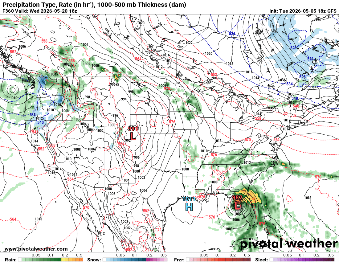
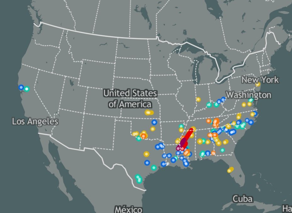
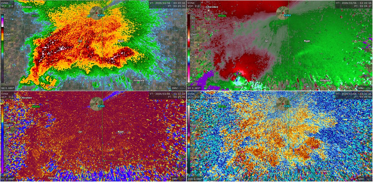
Eventually the luck will run out. Maybe 2-3 miles North and we’re talking about a very different scenario with a intense+ tornado traversing into densely populated neighborhoods.
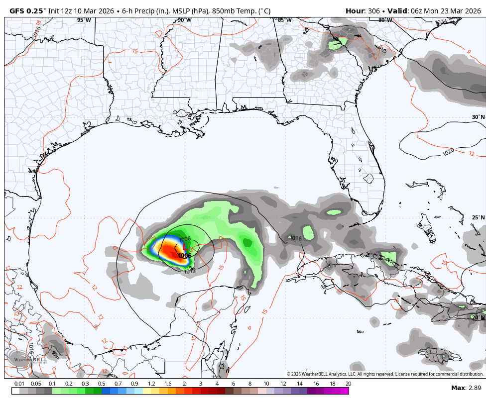
English
39
16
483
108.7K
Bryce Shelton
Bryce Shelton@BryceShelton01·
March madness on the GFS with a tropical storm in the Gulf late month
Bryce Shelton tweet media
United States 🇺🇸 English
15
12
162
12K
Nick Krasznavolgyi
Nick Krasznavolgyi@NickKrasz_Wx·
Every significant tornado on radar from the March 5-7, 2026 tornado outbreak: - Fairview, OK EF2 (120 mph) | March 5 - Helena, OK EF2 (115 mph) | March 5 - Three Rivers, MI EF2 (130 mph) | March 6 - Union City, MI EF3 (160 mph) | March 6 ⬇️
Nick Krasznavolgyi tweet mediaNick Krasznavolgyi tweet mediaNick Krasznavolgyi tweet mediaNick Krasznavolgyi tweet media
English
4
36
170
9.1K
StoicWX 🌪️ retweetledi
Dylan Federico
Dylan Federico@DylanFedericoWX·
The brand new EURO Seasonal Model calls for a very strong El Niño to develop this Summer. This is a HUGE deal because El Nino events are typically associated with below-average tropical activity in the Atlantic Basin. This is reflected with a -AMO SSTA configuration with the warmest water focused in the subtropical Atlantic, along with anomalously high surface pressures, and below-average precipitation anomalies. This is the most hostile look I’ve seen leading up to an Atlantic hurricane season since 2015. #TropicalUpdate #flwx 🌀
Dylan Federico tweet mediaDylan Federico tweet mediaDylan Federico tweet mediaDylan Federico tweet media
English
19
51
239
37.4K
StoicWX 🌪️ retweetledi
oish
oish@oiiiiish·
Peep the 2026 Tornado Season bingo card… #wxtwitter
oish tweet media
English
26
43
373
24.5K
StoicWX 🌪️ retweetledi
Lincoln Hauser
Lincoln Hauser@Lincoln_Wx·
Guy next to me on Pivotal Weather
GIF
English
2
7
173
4.6K
StoicWX 🌪️
StoicWX 🌪️@StoicWX·
At this point add CAT 6 for sub 900 Hurricanes
English
0
0
0
13
StoicWX 🌪️
StoicWX 🌪️@StoicWX·
If it wasn’t for jamaica this thing would have probably gotten the record…
English
0
0
0
148
StoicWX 🌪️ retweetledi
Matthew Cappucci
Matthew Cappucci@MatthewCappucci·
Today is a grave, grim day. The sun just rose in Jamaica. This is the last time the landscape will look as it does today. About 40% of the island is about to lose most of its vegetation; the landscape will be deforested and defoliated. The scar etched in the landscape will take a decade or more to heal. The EYEWALL is approaching. It's still replete with lightning, suggesting a storm maintaining intensity or even strengthening. The innermost buzzsaw of winds will bring tornado-like conditions for up to 3 HOURS. Most well-built structures will be severely damaged or destroyed. Flying debris will become lethal missiles. Compact cars and smaller SUVs will be lofted. High-rise and multi-story apartment buildings will lose all windows and some sections of roofs and walls; a few may sway dangerously, perhaps to the point of total collapse. For those in the eyewall zone, SEEK SHELTER! Move to a basement or interior room on the lowest floor of your home or business that can't flood. Once the leading edge of the eyewall passes, be aware that the winds will switch direction.
Matthew Cappucci tweet media
English
52
236
1.4K
152.9K