
Waiting4Weather
5.9K posts
Waiting4Weather
@Waiting4Weather
Fascinated by weather of all kinds...Especially snowstorms
Katılım Kasım 2016
214 Takip Edilen188 Takipçiler


Tornado probabilities this high at hr 204 tend to only occur around 25 times per year!
The tornado threat for April 3rd seems to be trending up some. Still considerable uncertainty.
StormNet@StormNetWx
A long-range threat of tornadoes and severe storms has been detected for Friday, April 3rd across the Plains and Midwest. This forecast initialized on Thursday afternoon (3/26). Follow this page and see the app for future forecast updates.
English

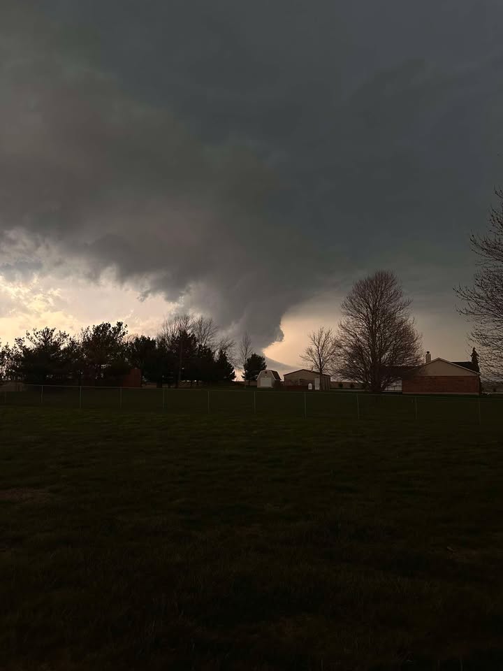
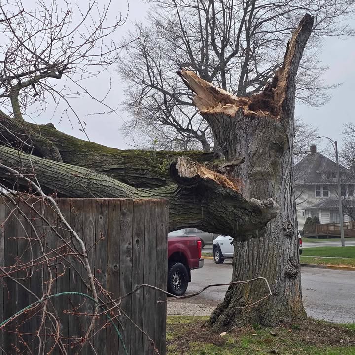
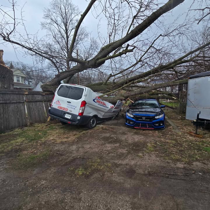
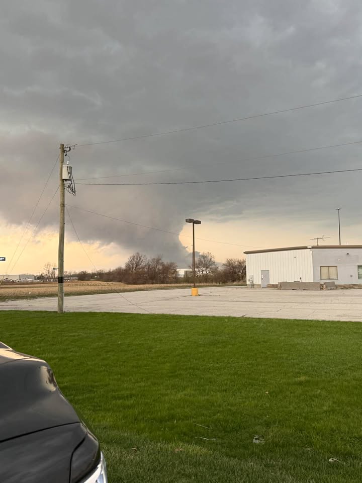
Viewers are sharing photos of the severe weather moving across Indiana.
MORE: wthr.com/gallery/weathe…
(📸: Deb Sanders, Lori Shaver, Carly Harmon)
English

3-26-26: ⚠️ Live Severe Weather Coverage x.com/i/broadcasts/1…
English

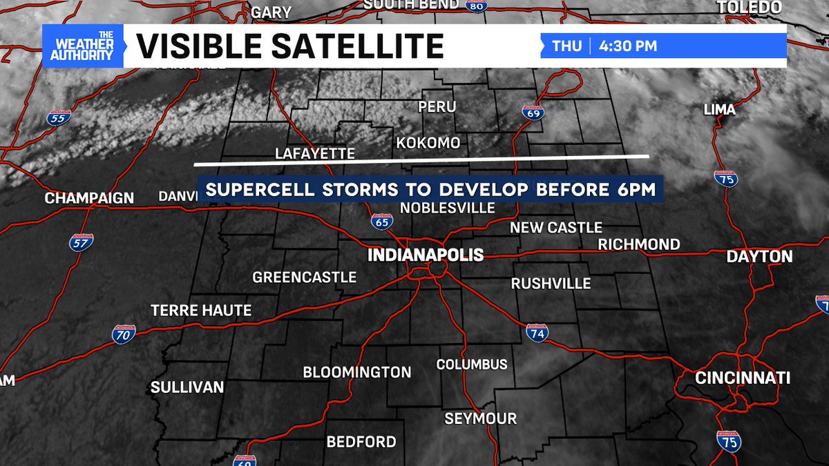
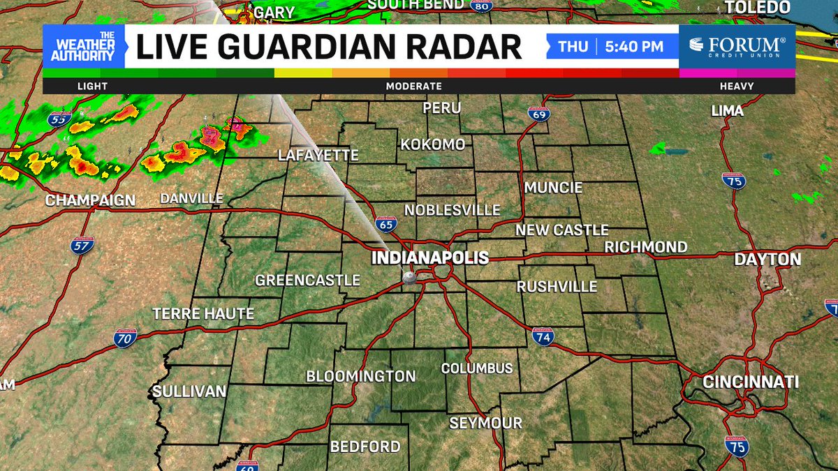
Right on cue - one hour later these storms crossing into IN are going to keep building. First warnings of the day will follow. #INwx
English
@MitochondriaJC @NWSIWX Yes. 80% chance of one according to SPC
English

@NWSIWX Is Northern Indiana gonna get a Severe Thunderstorm Watch soon?
English
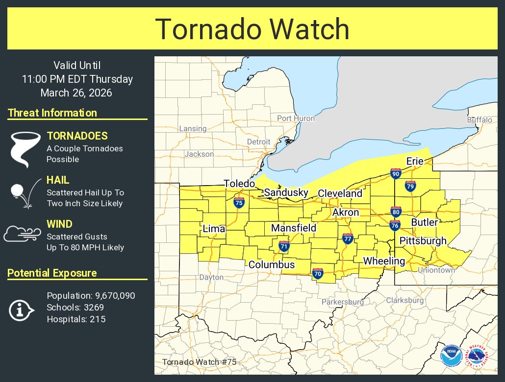
A tornado watch has been issued for parts of Ohio, Pennsylvania and West Virginia until 11 PM EDT
English


🚨RISK UPGRADE - The Severe Weather Threat for tomorrow has just been UPGRADED.
Tree Toppling Winds, Car Denting Hail, and a few Tornados are possible as Storms SLAM through the Ohio Valley.
More Details below ⬇️
English
@MatthewCappucci Why don’t you go there then and drink some Arab hail? And just stay there
English

Late week, you're likely to hear about SERIOUS flooding potentially impacting Dubai and/or Abu Dhabi.
Parts of the Arabian Peninsula, particularly along the Persian Gulf and Gulf of Oman, will flood.
Yes, parts of the desert have a flood/tornado risk. WILD setup.
MyRadar Weather@MyRadarWX
To make things even wilder, divergence – spreading air aloft – will help lift moisture, generating heavier rainfall. There's a chance that Dubai could see 3-6 inches of rain (maybe more!), equating to a year's worth of rainfall.
English
There are still uncertainties in regards to timing, as well as whether or not instability and moisture will be sufficient. All hazards including hail, damaging wind, and tornadoes are possible should severe storms develop Thursday afternoon and evening.

English
Dry conditions will persist through Wednesday with increasing temperatures each day. A cold front will bring rain showers and chances for thunderstorms on Thursday. Storms may be severe Thursday afternoon/evening. Noticeably cooler on Friday with lingering morning rain showers.

English
FROG SIZED Hail Storm in Columbus Ohio.
Not quite Hamster Sized Hail, but close… 🐹
English
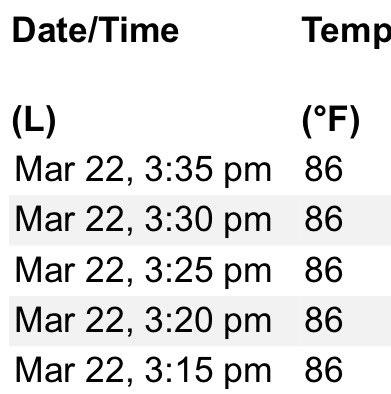
As of 3:15pm this is officially the hottest March temperature (86) in Indianapolis ever documented. Beating the old record of 85 set back in 1981!
English


@seckhardt He’s one of the main people that do that. After he preached about it.
English

This is so broad for a worst case scenario. And exactly the type of stuff that makes its way into the average person's social media feed that's not even thinking about weather. There needs to be a way to convey directly up front that 1/10,000 of the area outlined might see egg sized hail. Can't believe were doing this again less than a week later.
Matthew Cappucci@MatthewCappucci
SUNDAY, March 22 could feature some hailstorms along the Ohio River and in southwestern/south central Pennsylvania. The Storm Prediction Center is now cautioning that a few rotating supercells with large hail potential are expected to form. IF a supercell can become established, it could produce large hail up to about hen egg-sized... roughly 2 inches across. Rotating storms are the most efficient at producing hail, and these will be rotating storms. Why a minimal tornado threat? Scant low-level moisture. It will be dry near the surface. If we pump more moisture north than originally expected, then a tornado threat could materialize. That's TBD.
English


The way that you speak to me, freak with me, gives me a rise.
English
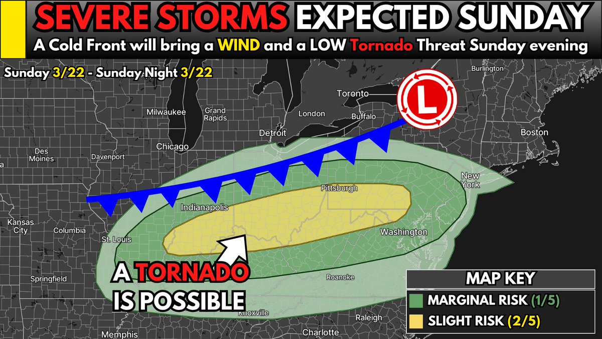
OHH MOMMA… we’ve got Severe Storms coming back tomorrow in the Ohio Valley.
Will this threat be terrible?
Probably not.
But it’s definitely something to watch.
A SLIGHT RISK (2/5) is in place as a Cold Front pushes through and fires up Storms.
Here’s what to expect ⬇️
🗺️ WHERE
Storms develop from Cincinnati, Columbus, and Pittsburgh, then slide southeast across the Ohio Valley.
⏰ TIMING
Storms get going mid to late afternoon (3–6 PM) and continue into the evening.
⚠️ MAIN THREATS
🌬️ Damaging winds (main threat)
🧊 Large hail early on
🌪️ A Tornado or two possible
Storms will stay isolated early on, but then they’ll likely merge into a line as the night goes on.
👊 Keep your head on a swivel tomorrow, my brotheren
English
@seckhardt Yeah people love to fear monger for attention. Really pisses me off
English
Noting that tomorrow could be an interesting early season severe weather setup is all that needs to be said today. Anyone posting that people need to be aware, prepare, or anything of that nature, just stop. If needed, that all could be said this time tomorrow.

Nadocast@nadocast
12Z Day 2 Tornado Forecast for 2026-3-22 (New New 2022 Models)
English
Early April, particularly between April 1-8, looks active from a severe weather/tornado standpoint. We'll also likely see above-average rainfall across portions of the Ozarks, Mid-south and Mississippi Valley.
A large-scale pattern reversal will favor troughing, or a jet stream dip in the west. Chilly air will spill south over the Rockies in that jet stream dip. Warmth and moisture will build in the east.
Periodically, lobes of that cold pocket will pinch off, bowling eastwards and kicking up that warmer, wetter air mass over the Central U.S. With the jet stream roaring overhead, adding wind energy, some of the storms will be strong to severe. I expect an uptick in tornado activity as well.
It's also the time of year when tornado activity tends to ramp up anyway. Now is a good time to clean the cobwebs out of the storm cellars, brush up on your severe weather plan and coordinate with friends, family and loved ones.

English
