
Muggsy
354 posts

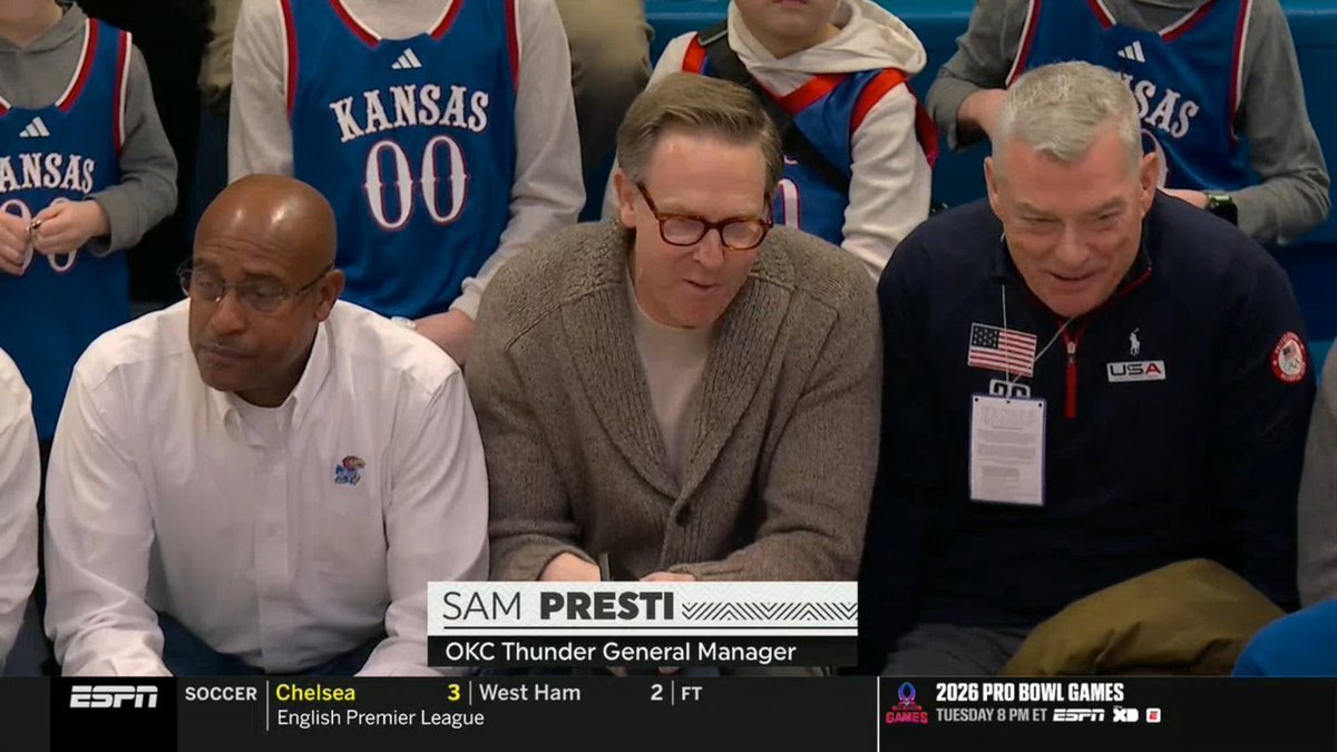
Look who showed up to watch Darryn Peterson and AJ Dybantsa
English

Time to address this..
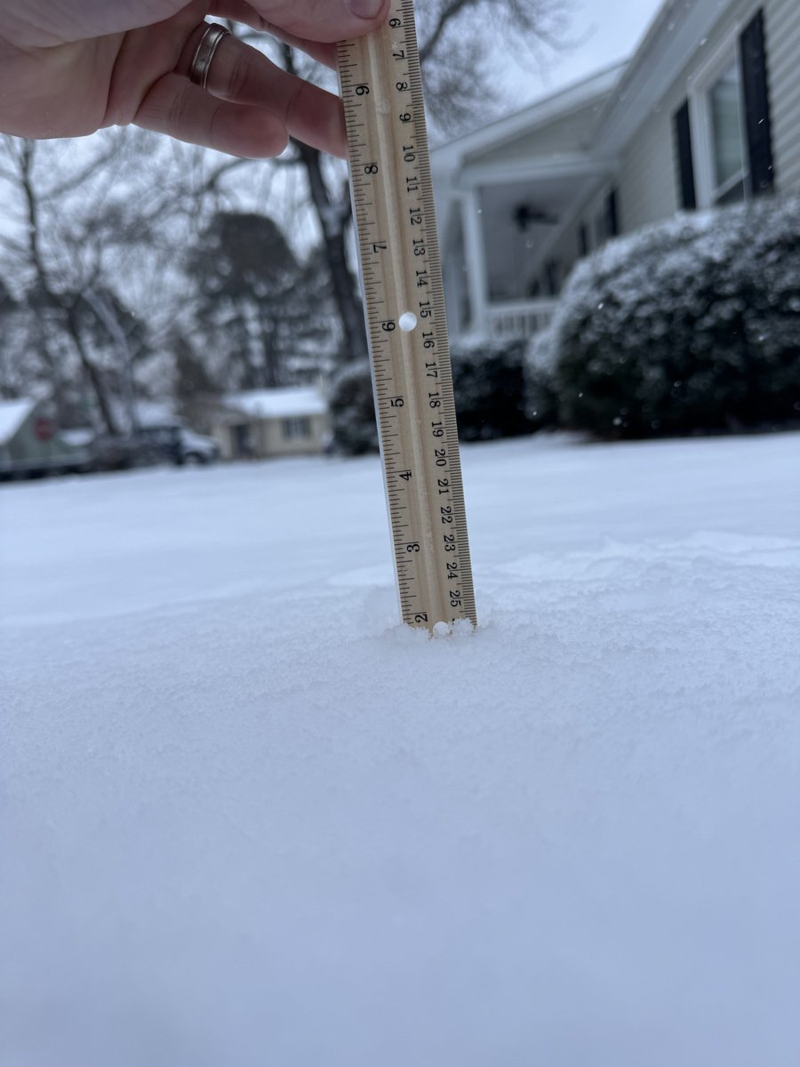
I’m like 90% it is for Columbia. Just trying to enjoy what we have. But admittedly I’ve had a bad feeling since this morning. But we will need a miracle for the original 6-8 inches to be realized here in Columbia. Sucks, but I’m trying not to be negative. Short range guidance trended North all morning. But who knows, maybe it’ll do something wild this evening. I’m at around 2 inches currently. We’ve done went back to a dandruff blizzard again.
Also shocked that it’s 21° & snow isn’t accumulating to the roads much. Been a cold week so that’s kinda wild to me.
Need heavier snow to return. I hate how bandy the snow is also. We will see what this backside snow does this evening.
GIF
colton@coltonscwx
@SCweather_wx Mitch this looks like its gonna underperform. I'm a littke on edge.
English

Another blast of very cold Arctic air will invade Alabama and the Deep South this weekend. A few snow flurries or snow showers are possible tomorrow night into Saturday morning. Details on today's afternoon briefing: youtube.com/live/jD_gQLi5g…
YouTube
English
FRIDAY NIGHT/SATURDAY: Another Arctic front will roll through Alabama Friday. We could see a few sprinkles or flurries as the front passes, but nothing that will be impactful.
As the cold air rolls into the state, and a surface low moves northeast off the Atlantic coast, we will have the chance of snow showers over the northern half of Alabama Friday night and Saturday.
While no widespread accumulation is expected, where heavier snow showers develop a few spots could see up to a quarter of an inch by midday Saturday. Highest probability of this is over the northeast counties of the state.
This will be a significant winter storm to the east for the Carolinas and parts of Virginia.
Temperatures won’t get out of the 20s across North/Central Alabama Saturday after starting the day in the teens. Some limited travel impact is possible where the heavier snow showers develop, but again this won’t be widespread.
Colder spots across North Alabama will likely see lows in the single digits early Sunday morning, much like the temperatures we experienced Monday morning. The attached meteogram is for Huntsville.


English

The Pelicans are willing to trade Herb Jones or Trey Murphy III if they receive a Desmond Bane–type trade package in return, per @TheSteinLine
“I’ve heard this one from multiple teams lately: They would want a Desmond Bane-type offer. Orlando parted with four future first-round picks and a first-round pick swap to acquire Bane from Memphis in June.”
(Via substack.com/redirect/2/eyJ…)

English

@DixieChasing Doesn’t look like it even knows what it’s gonna do. Showing snow in the Gulf of Mexico lol
English

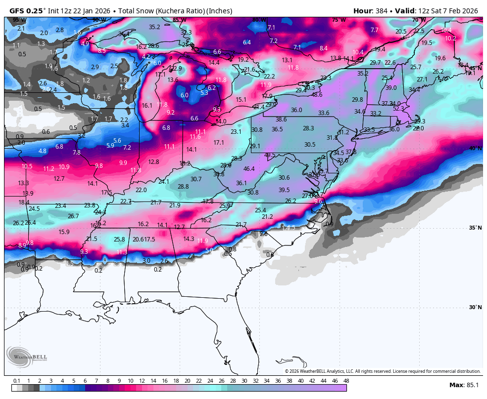
18z GFS still likes to show the moisture off the coast getting suppressed and pushed out into sea for our area of interest next weekend.🌨️
GIF
English
@DixieChasing @SCweather_wx I’d rather the storm have to shift a little north than a little south ngl
English
@treywallace They need to put a bowl ban on ole miss for the upcoming year. Cause they have been doing this to other teams also I’m sure there’s a lot more evidence.
English

Dabo Swinney went on a massive rant against Ole Miss, Pete Golding, Rebels GM Austin Thomas for blatant tampering with Luke Ferrelli
Dabo just put Ole Miss on blast, saying Pete Golding offered him a $1 million contract while in class at Clemson.
“Like having an affair on your honeymoon”
English
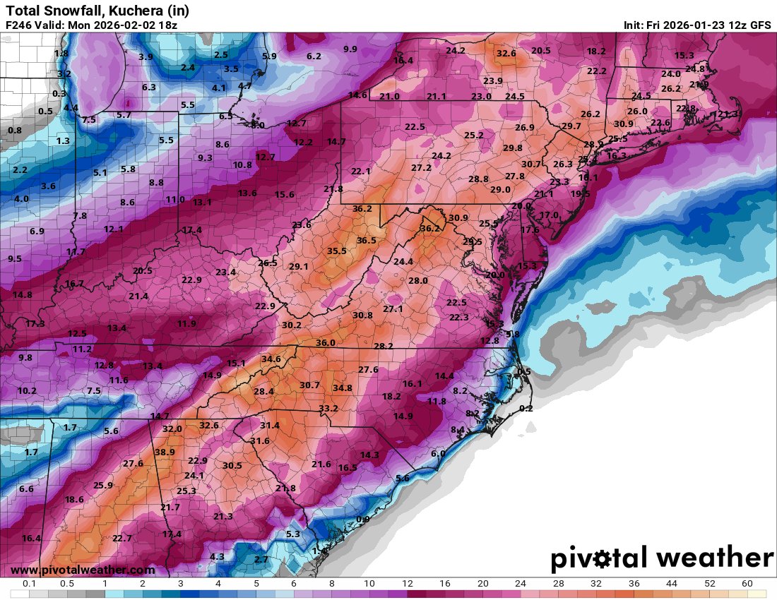
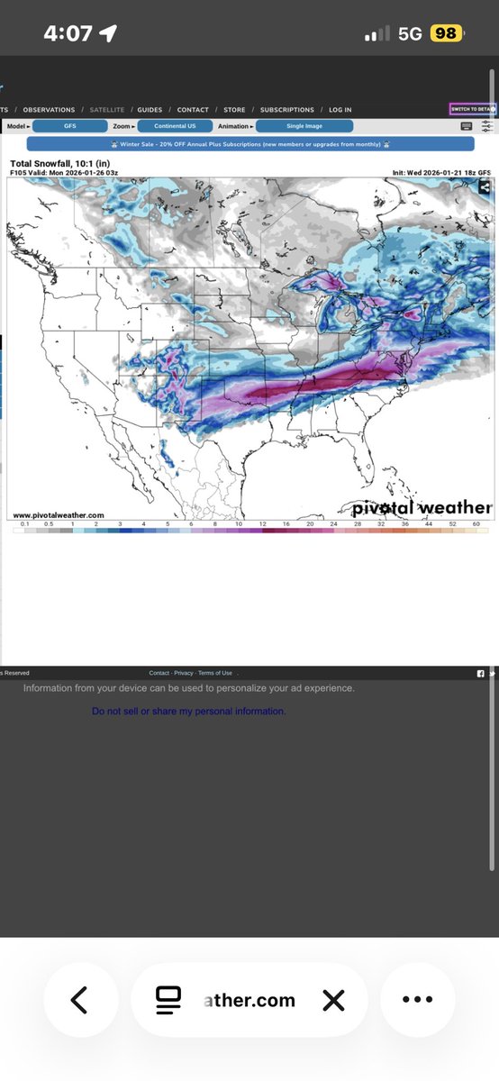
12z Euro has the storm also.
In fact all model guidance has a Gulf low lurking with an Arctic airmass to work with. This will be a fun one after this weekends storm to track. Can't wait for glory or heartbreak again.
Mitch West@SCweather_wx
GFS printing out on of the best Southeast snowstorm fantasy runs of the Winter for next weekend.
English

@hollywoodszn @spann So we go from strong thunderstorms to possible snowflakes in the same day. Can’t make this shit up 😂
English
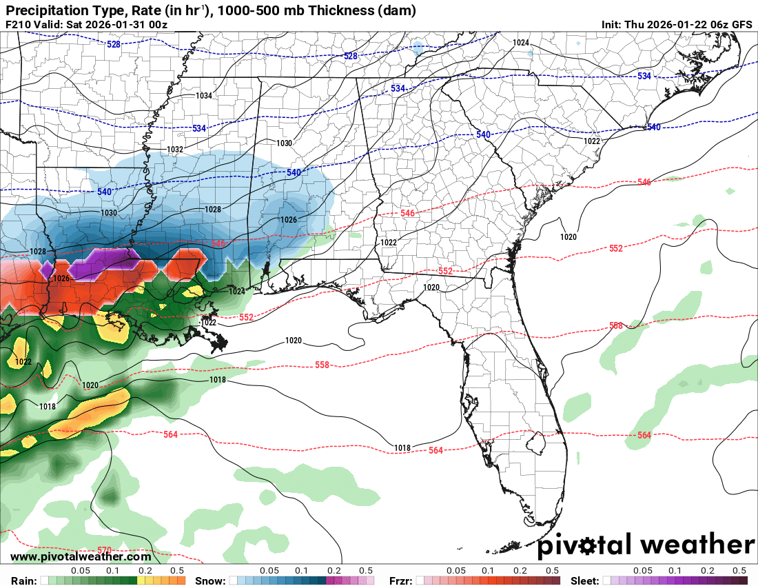
THURSDAY NIGHT NOTES: Watching new data roll in tonight... here are a few notes and thoughts concerning the weekend weather situation in Alabama.
*The new HRRR high resolution model (00z) shows light freezing rain moving into Northwest Alabama Saturday morning between 5:00 and 7:00 a.m. By afternoon, temperatures warm above freezing over most of North Alabama with the exception of the northwest corner of the state around Florence and Waterloo.
*Highest chance of ice accumulation Saturday is across Lauderdale, Colbert, and Franklin counties. How much ice? It all depends on how surface temperatures behave. It could be anywhere from 0.05" to over a quarter of an inch, and it is a very close call.
*For the rest of Alabama, it will be just good ole fashioned rain Saturday.
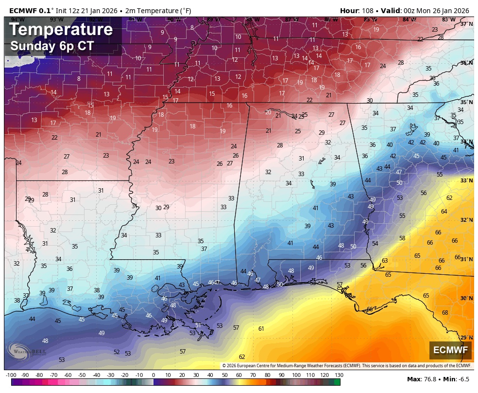
*As the warm sector of the storm system moves northward, temperatures could actually rise overnight Saturday into Sunday morning. This should ease the icing across the northwest corner of the state. Temperatures could reach the low 60s as far north as Birmingham Sunday morning.
*The possible exception Saturday night is the northeast corner of the state, where the cold air damming (CAD) effect could bring in colder air from the east, and some freezing rain could fall there, mainly across parts of Jackson, DeKalb, and Cherokee counties.
*Sunday morning will feature rain and a few thunderstorms statewide. Maybe even a few strong storms over the southern half of the state.
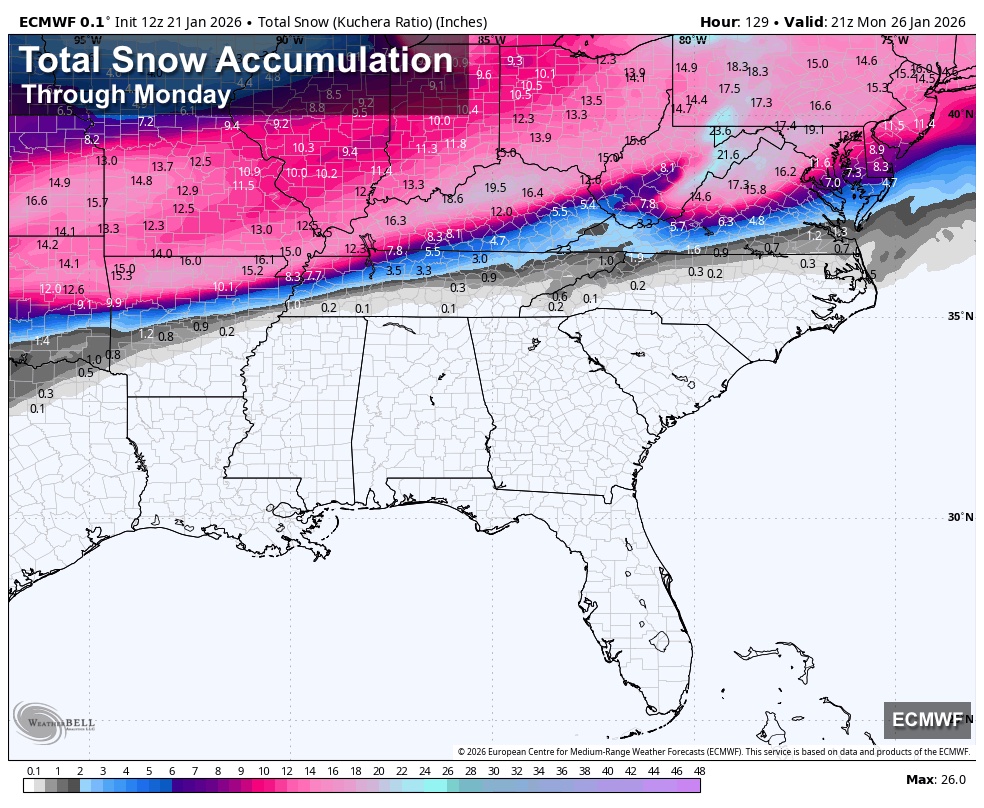
*Temperatures will drop like a rock Sunday afternoon over the northern half of the state, and there could be a window for some freezing rain or maybe even a few snow flakes on the back side of the big precipitation mass.
*Temperatures will drop into the teens Sunday night across the northern half of the state, and after 2-3 inches of rain there is a very real chance of a flash freeze/black ice into Monday morning. This could create hazardous driving conditions.
*Temperatures over the northern half of the state will likely stay below freezing all day Monday.


English
@DixieChasing I mean it’s supposed to be 65 degrees in Birmingham not buying it 😂
English
Do y’all buy the models punching warm air that far north ? I have a suspicion that wont happen. I know models do handle Arctic air very poorly.

English

@BBBrad91 @BryceShelton01 lol that’s not going to be accurate at all
English

Buy everything you need now. The new ice age is coming. Thank you GFS.
United States 🇺🇸 English
@JoshHasAProblem Please man I just want one snow in central Al this year. Not asking for much.
English

If y'all were wondering, yes, the Big 2 weather models do show another potential winter storm sometime next week going into the weekend--of course, this is WAY too far out to really say much about other than the pattern aloft supports it. Let's get through this weekend with power (like, literally, we need the lights to stay on), and then we can yap about this.
English


@BrandonLaneWX This is the new 18z gfs, it’s shifted south.
First southern shift since 2 days ago.
English

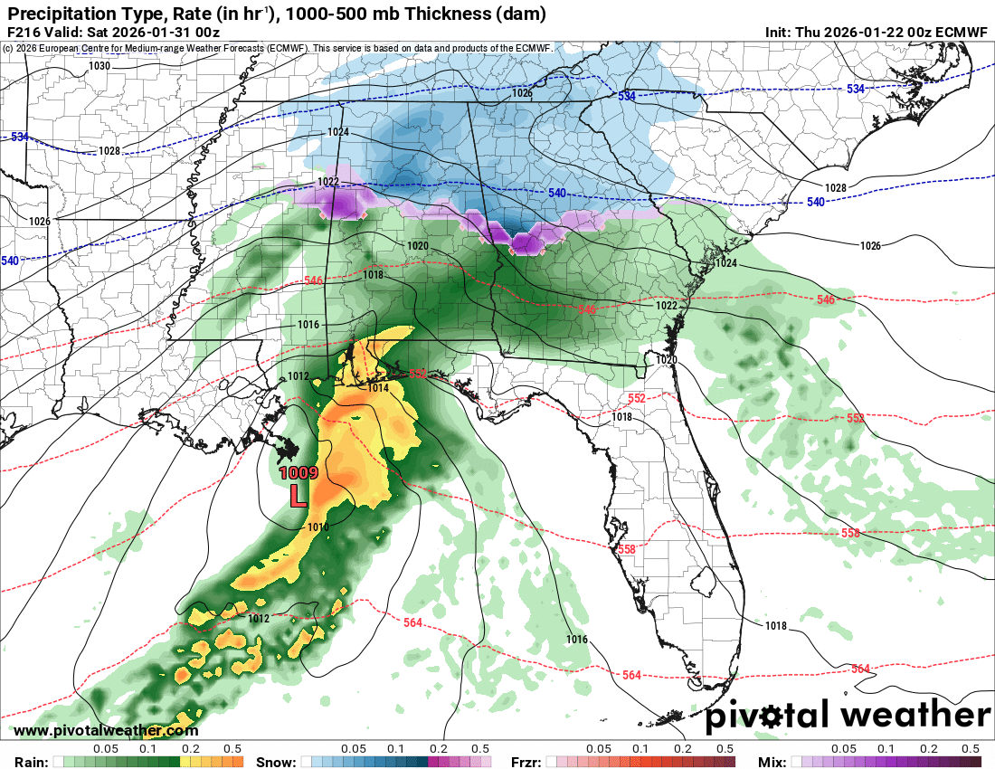
WEDNESDAY MIDDAY UPDATE: Some notes after a review of the new 12z model set that is in... the weekend forecast is very complex.
*Some freezing rain will likely begin across Northwest Alabama Saturday morning with temperatures in the 27-32 degree range. Ice accumulation is likely there through midday, but by afternoon mid to upper 30s are likely, which should ease icing conditions.
*The reliable European global model continues to show a large warm sector (relatively speaking) associated with the surface low moving northward. This should keep much of North Alabama above freezing from Saturday afternoon through early Sunday morning. It suggests temperatures will be in the 55-60 degree range Sunday at 7a CT as far north as I-20... upper 30s and low 40s are likely across the western half of the Tennessee Valley at that time.
*However we will have to watch for a CAD pattern (cold air damming) to bring colder air into Northeast Alabama Saturday night; this could open the door for some freezing rain and ice issues across counties like Jackson, DeKalb, Cherokee, and Cleburne.
*For the rest of Alabama , with the warmer air in the low levels, precipitation should be mainly rain Saturday night into early Sunday.
*Temperatures will fall quickly during the day Sunday as the surface low moves northeast, away from the state. But the precipitation will be ending as the cold air rolls in. There could be a period of snow or freezing rain on the back side of the large precipitation mass Sunday afternoon.
*Temperatures will drop into the 10-18 degree range over the northern half of Alabama by daybreak Monday, and some black ice issues are a very real possibility on roads Sunday night and Monday. Temperatures over North Alabama will stay below freezing all day Monday despite the return of sunshine.
BOTTOM LINE: With the trend toward warmer temperatures in the low levels, much of the precipitation across Alabama will likely be in the form of rain over the weekend. However, there are three windows of concern.
-Icing across Northwest Alabama Saturday morning at the onset of the event
-Icing across Northeast Alabama Saturday night (cold air damming)
-Black ice on roads across the northern half of Alabama Sunday night and Monday morning.
A winter storm watch remains in effect for the northern third of Alabama.
It is still too early for a specific impact forecast, we will have that posted here early tomorrow morning. And, remember, any forecast can change, so watch for updates.I will have a few video briefing by 3p CT.


English
@MaxVelocityWX So it’s going to be in the 60s in northern Alabama? We really can’t ever have shit in the winter man.
English

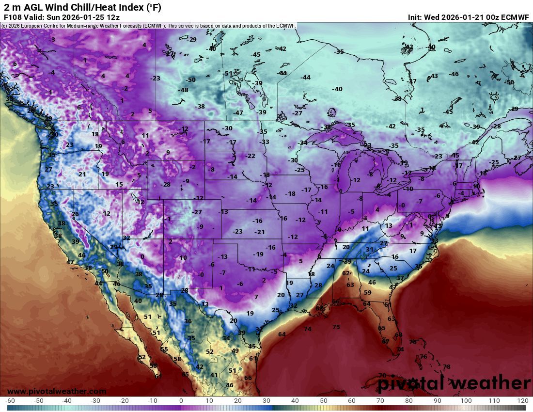
The entire country is going to be EXTREMELY cold Sunday 😳
Wind chills subzero from Texas to the Northeast. Florida might be the only safe place.
English