
Sriram Ramesh
100 posts

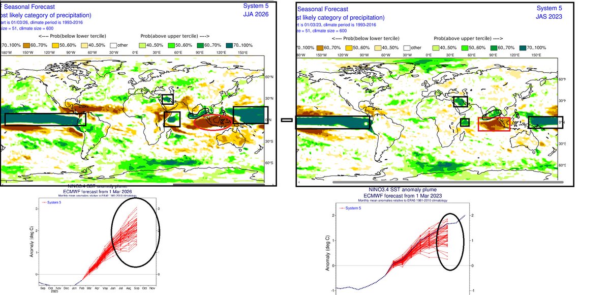
Alarming bell across Asia, Australia as ElNino ,+IOD combo set to return soon as early as May/June after 2 years of #LaNina regime .
While comparing it with recent 2023 event,the anomalies are inline with ElNINO + IOD conditions but with significantly larger anomalies, indicating there is a potential threat of even more stronger event..
Could be even strongest (??)
Asian monsoon season would coincide with this event so Indian monsoon & East Asia monsoon likely to get influenced by these 2 major climate drivers.
Elnino,+IOD generally leads to large scale dryness associated anomalous high pressure so below normal rainfall across India,Indonesia &Australia with some exceptions regionally.
Positive IOD associated surface divergence over Eastern Indian ocean adjoining Indonesia leads to enhanced cross eq flow .This anomalous flow along with seasonal SW flow helps to strengthen the Bay of Bengal branch of SW Winds associated lower level convergence so enhanced +rainfall anomalies over Bay waters, extending into #Thailand #Bangladesh #Myanmar into most of Indo-china peninsula .
Generally Indian monsoon rains gets influenced by inter-annual & intra-seasonal oscillations. so the relationship gets complicated when multiple factors interact at the same time..
For instance , NW India,western India suffers large scale suppression /below normal rains during el nino regime but 2023 monsoon was unusually different with enhanced rains associated with frequent mid lat westerly trough. 2018/2019 was also different with modoki pattern so in a warming era, relationship getting complicated .. lets see how this year behaves
#ElNino #India #ENSO #Monsoon #Monsoon2026 #Positiveiod #IOD #Indonesia #Australia #Pacific
dc @ECMWF
English
@chennaiweather @chennaiweather apologies sir but you are the one who mentioned that we should never see models for rainfall quantum but now you are posting the model predicted rainfall quantum.any reason sir
English


The Easterly wave might bring light to moderate spells on December 17/18, and then mostly dry weather is likely till the year-end (unless a surprise change occurs).
English
@chennaiweather Michaung was a cyclone that was aided by mjo as well
It had cdo clouds that can dump massive rains and when it came very close to chennai those clouds fell over the entire chennai region and gave widespread non stop downpour to the entire city unlike ditwah
English
This is a Michaung cyclone sat image, and it was completely moisture-filled
English
Why and how did dry air relax when the system moved parallel to the Chennai coast, which brought huge rainfall to a few pockets of#Chennai
Thread...
English

@abraham01679523 Only north Chennai again and again 😭 city nothing there
English
@king_rizu Plus november was totally dry in 2025 there was no soil saturation
Still they are using pumps to drain water
So what's the purpose of the storm water drain project here
English
@king_rizu We should not compare 2025 and 2023 with this rainfall event.
This was more localised and distributed spells with big breaks whereas michaung gave 40+ cms widespread rains across entire city in a short time within 24 hours.
2015 no need to say we all know
Nature saved TN not govt
English

I lived in this area for over a decade, from 2004 to 2016. My house is barely 500 metres from this spot. My brother still lives there—he’s been there since birth. And honestly, we’ve never seen this place remain this dry after such heavy rain. For people who know this neighbourhood, it feels nothing short of a miracle.
Chennai’s flood preparedness is not built in a day; it needs constant, patient effort. With a growing population and rising infrastructure demands, the city will keep expanding, and a permanent solution is still a distant dream.
But credit where it’s due—this government has done an incredible job. So stop blabbering without knowing the ground reality.
Kudos @mkstalin @Udhaystalin @PriyarajanDMK @PKSekarbabu @kgbias
@Alien18R @angry_birdu @dhans4all @dstock_insights @iVenpu @teakkadai1

English
@chennaiweather Easterly- rains can come at any time with breaks at time heavy spells especially during nights
North easterly - sunny with occasional moderate or drizzle spells
Northerly -dry and winter 😃
English
Forecast for the next few days for the #Chennai region
3 -4 Dec- Intermittent spells (reduce in 12-24 hours)
5 Dec- Lite rain/Sunny intervals
6 Dec onwards -Mostly dry.
English
@chennaiweather @Anand____4324 Ok sir.
But there should be some basic understanding that rain bands can form anytime anyplace when the system is in such close proximity.
Yesterday was a clear example
English
@sriram1332 @Anand____4324 Boss, they don't know, even radar is nowcast. don't reply to such comments. They are thinking we are getting money from X
English
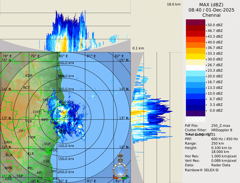
8:50 am : New rain band is forming close to the coast all of the sudden
English
@Anand____4324 @chennaiweather What will he do if a convection bloom all of a sudden
Imd with equipment and technology worth several crores could not even guess the rainfall that came yesterday.
Stop putting down weather bloggers.
They all have a full time job and do this out of passion and not earn money.
English

@chennaiweather Bro there are other ways to earn twitter payout. Stop fooling around with weather reports. Been observing your posts over the last week, it’s clear proper weather reporting is above your qualification.
English
@chennaiweather Hi @chennaiweather sir
Won't the system's northern movement be stopped after chennai latitude due to westerly trough ?
English
@chennaiweather Hi sir
This spell feels like a cloud burst kinda rains
It's literally bucketing down
English


#Watch | பூந்தமல்லி நெடுஞ்சாலையில் தேங்கிய மழை நீரை விரைவாக வெளியேற்றி வரும் மாநகராட்சி ஊழியர்கள்.
#SunNews | #ChennaiRains | #WeatherUpdate
தமிழ்
@praddy06 Hi sir.. you mean this is the last spell from this system?
English

Ditwah Rain update - Very intense bands moving into Chennai city from north.
Rain intensity will pick across the Chennai City for next 120 minutes. Slow moving one. No further clouds is seen above pulicat.
This will be the spell before we go into break so enjoy the next 2 hours spells.
English
@chennaiweather Hi sir,
Models are predicting the system will not move above chennai latitude and continues to linger around chennai till tomorrow before moving inland
But your post says it's moving north.
Any changes in forecasted path sir ?
English
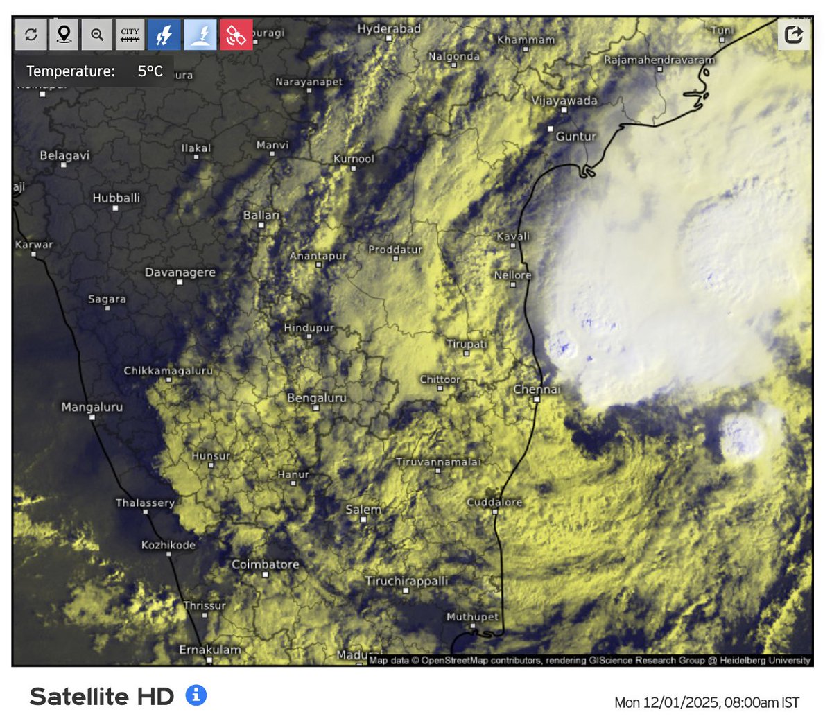
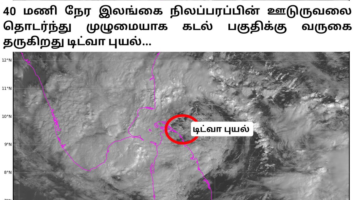
8:30 am update: The weakened #CycloneDitwah circulation centre is now located just southeast of the #Chennai coast and will move north slowly.
A huge convective mass is present near the South Andhra Pradesh coast, skirting only the extreme North Tamil Nadu coast (Tiruvallur district).
Dry air dominates the west and southwest quadrants of the system.
பலவீனமான #CycloneDitwah சுற்றுச்சுழற்சி மையம் தற்போது #Chennai கரையின் தென் கிழக்குப் பகுதியில் உள்ளது, மேலும் மெல்ல வடக்கு நோக்கி நகரும்.
தென் ஆந்திரக் கரையோரத்தில் பெரிய அளவில் மேகங்கள் காணப்படும் நிலையில், வடக்கு தமிழகத்தின் கடைசி முனைப் பகுதிகள் (திருவள்ளூர் மாவட்டம்) வழியாக மட்டுமே அது நழுவுகிறது.
மேற்கு மற்றும் தென்மேற்கு பகுதியின் மீது வறண்ட காற்று மேலோங்கியுள்ளது.
English

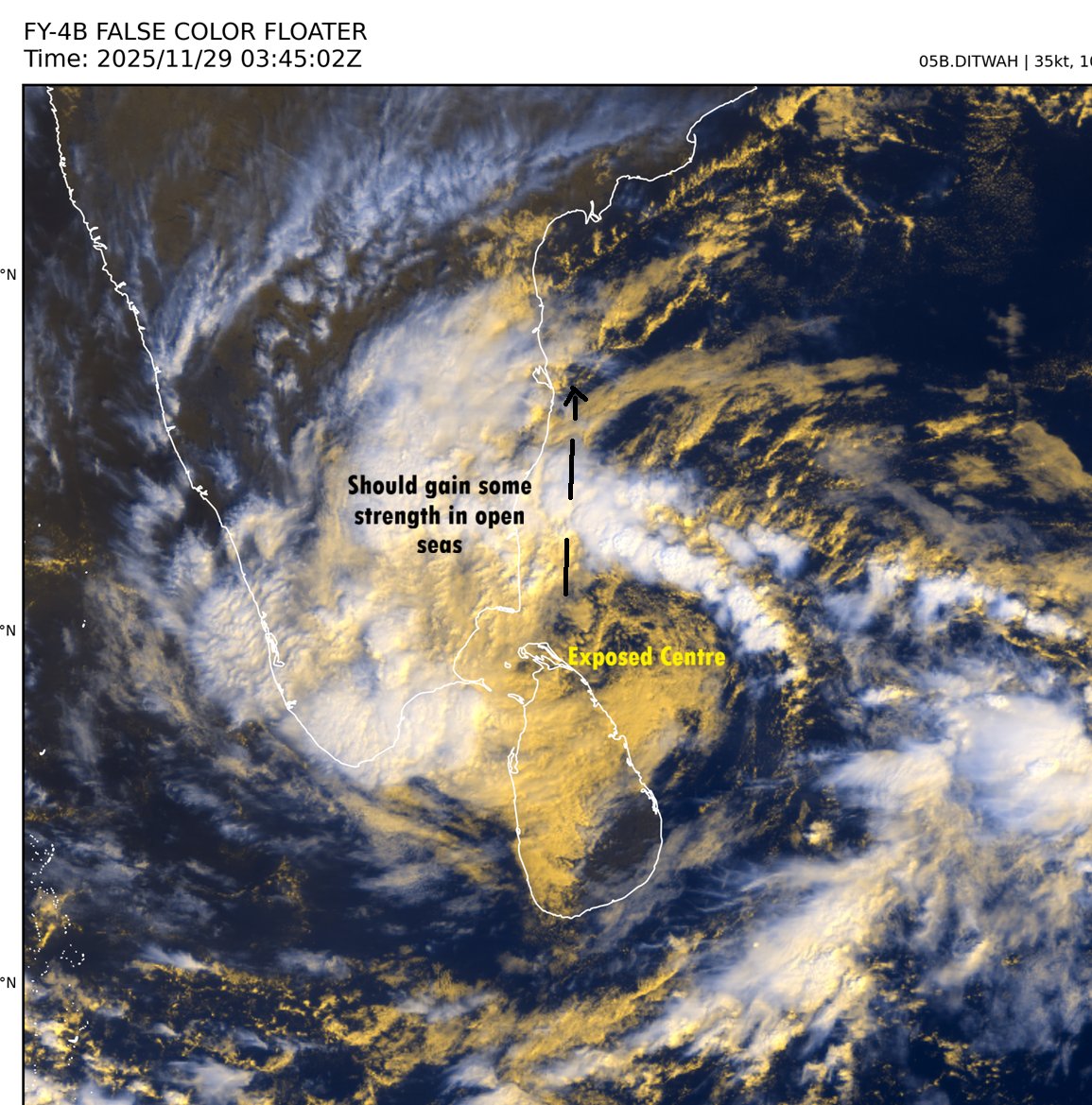
Cyclone Ditwah looks helpless as dry air and shear is ripping the system apart. Northern convection seems to be loosng steam completely. Need fresh convection to develop for its survival.
#CycloneDitwah #Monsoon2025 #NEM2025 #Chennairains

English
Cyclone Ditwah 29th Noon update
--------------
It will move parallel to the Tamil Nadu coast as coastal bypass rider and come close to Chennai coast on Sunday evening as a Deep Depression.
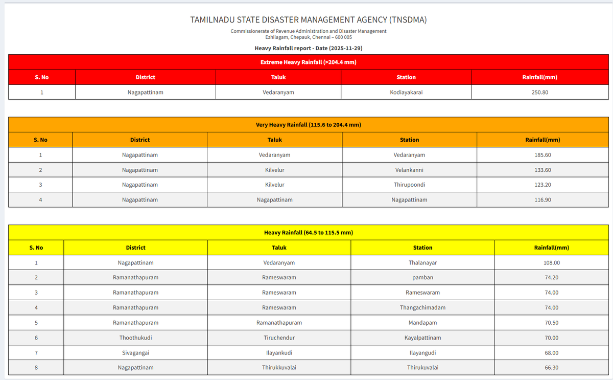
Observed Rainfall - Heavy rains have commenced in the Delta belt - Nagai district in particular with stations close to sea have recorded over 175 to 250 mm particularly areas close to sea.
Forecast for next 24 hrs - As the Cyclone is in open sea off the delta coast, delta rains will continue till evening and the rains will slowly shift up next to Cuddlaore then Pondy.
KTCC (Kancheepuram, Tiruvallur, Chennai and Chengalpet) - Rains will increase from evening / night from ECR areas and then move up into city. Moderate to heavy rains can be expected in southern areas / Chengalpet. Sunday the best day for Chennai.
Heavy rainfall - Tiruvarur, Thanjavur, Trichy, Perambalur, Ariyalur, Cuddalore interiors places, Villupuram
Very heavy rainfall - Nagai, Mayildauthurai, Cuddalore and Pondy in the next 24 hrs.
Extreme Rainfall - Very isolated places in Cuddalore, Mayildauthurai, Nagai, Pondy belt is possible.
English
@Deltarains Hi @Deltarains .
The dry air channel seems to have widened
Will this dissipate the system
English

#BIGBRRAKING #FOCUSNOW
NAGAPATINNAM DT KODIYAKARAI TOP'S THE TABLE WITH 250MM EXTREMELY HEAVY RAINFALL
DWM "DITWAH" CYCLONE UPDATE -8| DATED -29.11.2025| TIME : 8:30 AM
#Topic: AFTER 40 HRS OF LAND INTERACTION, DITWAH MAKING GRAND ENTRY TO DELTA COASTS.
==> Nearly 40 hrs of srilanka land interaction, cyclone #Ditwah has entering delta coasts in very next hour. As of 8:30 AM today (29 November 2025), the Cyclone Ditwa is located approximately 170 km south-southeast of Nagapattinam and 180 km from Karaikal.
==> Extremely heavy rains recorded at Nagapatinam dt, Kodiyakarai tops with 250mm Vedaranyam 185mm, Velankkani 133mm, Thirupoondi 123mm, Nagapattinam 116mm. Nagapattinam dt averagely recorded 140mm.
==> The cyclone is continuing to move in a northerly direction and is expected to regain it's strength further as it approaches the Delta coast in the next few hours. The western quadrant of the cyclone is likely to begin affecting land areas in the Delta region during later par of today.
==> Heavy rain has now started in #Nagapattinam, #Tiruvarur, #Thanjavur, and #Mayiladuthurai #Cuddalore #Karaikal and #Pudhucherry districts, and it will gradually increase in intensity over the coming hours.
==> As the cyclone makes land interaction on the western quadrant of the Delta today (29 November) during the daytime, extremely heavy rainfall is expected across the region. People in the Cauvery Delta are requested to remain extremely cautious for the next 24 hours.
==> After impacting the Cauvery basin, the cyclone is expected to track its northward movement from this evening or night onwards.
==> Rain will begin in Chennai and other North coastal districts in the coming hours, and widespread heavy to very heavy rainfall, with extremely heavy falls at times, is likely from tonight (29.11.2025) until the morning of 1 December 2025.
==> Heavy rains likely to continue over South & interior Tamilnadu as well. Dts like #Pudhukottai, #Ramanathapuram, #Thoothukudi, #Theni, #Tenkasi, #Kanyakumari also will get heavy rains today. Most of the interiors also have good rain chances.
#ImportantNote: People in the Cauvery Delta districts are strongly advised not to leave their homes today.
Stay tuned for further live updates on Cyclone Ditwah.
Stay tuned & connected with @deltarains on X for timely updates as the system evolves! 🌧️
Thanks & Regards
Hemachander R
Independent weather blogger
Email: deltaweatherman@gmail.com
Disclaimer: This is purely my personal view and interpretation. Please do not bring other views from official agency or other private weather bloggers here. Understand that this is my own perspective, and I am ready to explain any queries regarding my post, not those of others.
#Cycloneditwah #chennairains #Deltarains
English