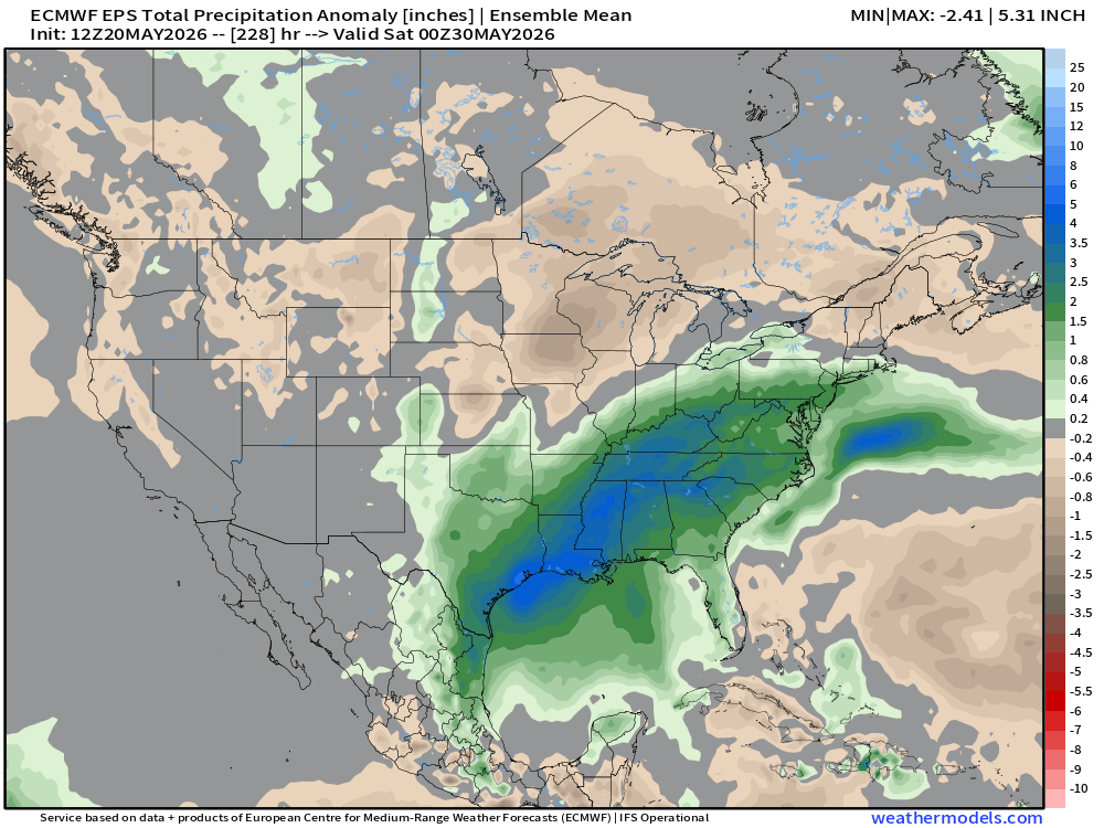
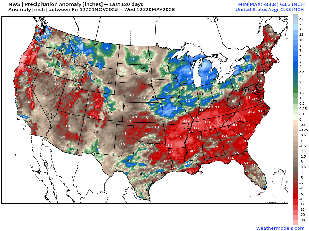
Weatherdle

298 posts

Weatherdle banner
Weatherdle

Weatherdle

@weatherdle_org

A daily weather-guessing game. Identify the mystery city from its 7-day forecast. New puzzle every day at 00:00 UTC. https://t.co/aqEtNUGhL7

Katılım Nisan 2026
71 Takip Edilen16 Takipçiler
Sabitlenmiş Tweet
Weatherdle
Weatherdle@weatherdle_org·
Weatherdle is a free daily weather-guessing puzzle. You see 7 days of real weather for a mystery city. 6 guesses to name it. New puzzle every day at 8 PM Eastern. No signup, no ads, no app — just a website. weatherdle.org #weatherdle #dailygames
English
0
0
2
424
Thierry Goose
Thierry Goose@ThierryGooseBC·
Exceptionally high temperatures in SW France with up to 34.7°C in Cambo-les-Bains [35.1°C in Léon, amateur station]. This is just the beginning of an historic heatwave. The May national record could be broken...
Thierry Goose tweet media
Meteociel@meteociel

Les températures ce jeudi 21 mai ont déjà largement dépassé le seuil des fortes #chaleurs (30°C) dans l'extrême Sud-Ouest du Pays. 🔸35.1°C à Léon (40) 🔸34.7°C à Cambo-les-Bains (64) 🔸34.3°C à Aicirits (64) 🔸33.6°C à la nouvelle station amateur de Saint-Julien-en-Born (40) ajoutée hier sur Météociel ( merci @carioca_cari) 🔸33.5°C à Biarritz (64) 🔸33.2°C à Biscarrosse (40) 🔸32.5°C à Carcassonne (11)

English
1
3
25
1.4K
Weatherdle
Weatherdle@weatherdle_org·
@tropicalupdate 378 hours is past the point where the model is forecasting anything — it's just churning noise that happens to look like weather. The screenshot does numbers because hurricane shapes pattern-match faster than the timestamp does.
English
0
0
1
39
Mike's Weather Page
Mike's Weather Page@tropicalupdate·
Another year. Another GFS doing GFS things. Model already spitting out phantom hurricanes. Be careful when these start spreading like wildfire across the internet. Couple red flags for me. Anything GFS the past several years. Anything 240+ hours out. If something looks credible you can bet I will be posting on it. Cheers! spaghettimodels.com
Mike's Weather Page tweet media
English
12
16
144
10.4K
Weatherdle
Weatherdle@weatherdle_org·
@ericfisher that overlap is rarer than it looks. Most months the wet signal lands where the soil already saturated last week, not where the deficit is.
English
0
0
1
23
Eric Fisher
Eric Fisher@ericfisher·
Biggest wet signal for the rest of the month is almost exactly where it is most needed/driest
Eric Fisher tweet mediaEric Fisher tweet media
English
6
4
83
10.7K
Weatherdle
Weatherdle@weatherdle_org·
@spann the names list always reads differently in May than it does in September.
English
0
0
1
21
James Spann
James Spann@spann·
NOAA released their outlook for the 2026 Atlantic hurricane season this morning…  Forecasters with NOAA’s National Weather Service are predicting a below-normal hurricane season for the Atlantic basin this year. NOAA’s outlook for the 2026 Atlantic hurricane season, which runs June 1 to November 30, predicts a 35% chance of a near-normal season, a 10% chance of an above-normal season, and a 55% chance of a below-normal season. The agency is forecasting a total of 8-14 named storms (winds of 39 mph or higher). Of those, 3-6 are forecast to become hurricanes (winds of 74 mph or higher), including 1-3 major hurricanes (category 3, 4 or 5 with winds of 111 mph or higher). NOAA has a 70% confidence in these ranges. An average season has 14 named storms with seven hurricanes, including three major hurricanes. “With the most advanced forecast modeling and hurricane tracking technologies, NOAA and the National Weather Service are prepared to deliver real-time storm forecasts and warnings,” said Commerce Secretary Howard Lutnick. “Our experts are integrating cutting-edge tools to ensure communities in the path of storms receive the earliest, most accurate information possible.” “NOAA’s rapid integration of advanced technology, including AI-based weather models, drones, and next-generation satellite data will deliver actionable science to safeguard the lives and livelihoods of the American people,” said NOAA Administrator Neil Jacobs, Ph.D. “These new capabilities, combined with the unmatched expertise of our National Weather Service forecasters, will produce the most accurate forecasts possible to protect communities in harm’s way.” The Atlantic season is expected to be below-normal due to competing factors. El Niño is expected to develop and intensify during the hurricane season, while ocean temperatures in the Atlantic are expected to be slightly warmer than normal and trade winds are likely weaker than average. El Niño conditions tend to support less tropical storms and hurricanes, while warmer ocean temperatures and low winds support a more active year. “Although El Niño’s impact in the Atlantic Basin can often suppress hurricane development, there is still uncertainty in how each season will unfold,” said NOAA’s National Weather Service Director Ken Graham. “That is why it’s essential to review your hurricane preparedness plan now. It only takes one storm to make for a very bad season.” NOAA’s outlook is for overall seasonal activity based on large-scale weather and climate patterns. It does not indicate where or when any storms may affect land as that is determined by short-term and variable weather patterns is not a landfall forecast. “Preparing now for hurricane season — and not waiting for a storm to threaten — is essential for staying ahead of any storm. Visit weather.gov/safety and Ready.gov for important preparedness information,” added Graham.
James Spann tweet mediaJames Spann tweet media
English
6
19
81
14.7K
Weatherdle
Weatherdle@weatherdle_org·
Hurricanes "need 80°F water" is the rule of thumb. The actual threshold is 26.5°C — which is 79.7°F. Three-tenths of a degree. Storms occasionally form over 79°F water. The line isn't a wall, it's a curve. A lot of meteorology is like that.
English
0
3
4
34
Weatherdle
Weatherdle@weatherdle_org·
Hawai'i's Big Island contains 8 of the world's 13 climate zones. Tropical rainforest on the east coast, alpine tundra on the volcanoes, arid desert on the leeward slopes — all within a 90-mile drive. One island has more climate variety than most continents.
Weatherdle tweet media
English
0
0
1
18
Matt Devitt
Matt Devitt@MattDevittWX·
Meanwhile in the Northeast. Record high already in Boston with 96º so far today. 🥵
Matt Devitt tweet media
English
7
14
125
8.3K
Ryan Hall, Y’all
Ryan Hall, Y’all@ryanhallyall·
The nicest weather in the USA today stretches from Portland, OR through Salem, OR to Eugene, OR. Open every window in the house.
Ryan Hall, Y’all tweet media
English
21
27
489
38.1K
Weatherdle
Weatherdle@weatherdle_org·
@ericfisher Seems AI was ahead a little bit! We may be seeing the AI forecasting take over
English
0
0
1
22
Eric Fisher
Eric Fisher@ericfisher·
In other news, some encouraging news continues for the weekend AI models remaining dry, and now the traditional GFS has joined them for both Saturday and Sunday Euro gave up on Saturday rain and hopefully will lose its Sunday rain soon as well
Eric Fisher tweet mediaEric Fisher tweet media
English
37
16
264
30.2K
Ben Noll
Ben Noll@BenNollWeather·
An emerging El Niño is about to make its presence felt in the United States 💧 An unusually strong subtropical jet stream will send copious amounts of moisture into the South — bringing drought relief — as well as some of the East. A stormy end to May with potential flooding!
English
6
95
335
14.3K
Weatherdle
Weatherdle@weatherdle_org·
The barometer falling means a storm is coming. The barometer falling fast means the storm is already here. The rate of change is the forecast. The number itself is just a snapshot.
English
0
0
1
22
Weatherdle
Weatherdle@weatherdle_org·
The Pacific just crossed from La Niña to El Niño threshold in two months. That kind of phase-flip used to take a season. Once the subsurface heat surfaces, the whole planet's weather rewrites its defaults — Australia gets dry, Indonesia gets dry, California gets wet, the Atlantic hurricane season gets quieter. Watch which places suddenly look weird this winter.
Weatherdle tweet media
English
0
0
1
36
Weatherdle
Weatherdle@weatherdle_org·
@PaxBiggs 10 years from radar-on-the-phone democratizing chasing to radar-on-the-phone breaking it. crowd-sourced data couldn't survive the crowd
English
0
0
6
1.9K
Weatherdle
Weatherdle@weatherdle_org·
@BianchiWeather the rare front range soak that fills the buckets without breaking anything. perfect rain
English
0
0
3
89
Chris Bianchi
Chris Bianchi@BianchiWeather·
Just crossed a half-inch of rain in downtown Denver. Fort Collins, Boulder, Longmont 1"+ already. Lots of water with minimal headaches. Exactly what the doctor ordered! #COwx
Chris Bianchi tweet media
English
9
15
316
11.1K
Weatherdle
Weatherdle@weatherdle_org·
@ReedTimmerUSA 10,000 feet inside the funnel and three loops on the way up is the kind of vertical profile data we basically never get. wild deployment
English
0
0
3
654
Reed Timmer, PhD
Reed Timmer, PhD@ReedTimmerUSA·
HISTORIC #TORNADO INTERCEPT southwest of Frankfort, Kansas! We launched a sensor into the tornado and it went up past 10,000 feet and did at least three revolutions around the tornado. Incredible data on this sensor #stormchasing #Dominator
English
36
213
2.7K
169.8K
Weatherdle
Weatherdle@weatherdle_org·
@TannerChasing this is what happens when the cone of uncertainty becomes a parade route
English
1
0
6
2.2K
Hunter Hurley
Hunter Hurley@hunterhurleywx·
not often we see the *entire* state of Missouri bathing in 60-70°f dewpoints,
Hunter Hurley tweet media
English
7
4
83
4.8K
Weatherdle
Weatherdle@weatherdle_org·
@RyanWeather @weathertrader IVT plumes that lock in over Texas this time of year are the closest thing the Gulf has to a rainy season switch. Berardelli was just calling foot-plus totals on the same pattern.
English
1
0
2
175
Ryan Maue
Ryan Maue@RyanWeather·
Good news if you want boatloads of rainfall especially in Texas ... weather pattern becomes persistent with strong Caribbean --> Gulf moisture flow into early June. Finally done with the silly Arctic blasts. Newsletter update (@weathertrader) weather.substack.com/p/may-18-2026-…
GIF
English
6
12
147
10.8K
Weatherdle
Weatherdle@weatherdle_org·
@vineet_mausam TONI vs RONI gap is the whole story here. Traditional says fastest ramp on record, relative says we're still chasing 97 and 15. The fact that those two indices disagree this much in May tells you how much background ocean warming is shifting the baseline.
English
0
0
1
37
Dr. Vineet Kumar
Dr. Vineet Kumar@vineet_mausam·
The 2026 Elnino evolution is moving faster than what we saw at this stage in 1982, 1997 &2015 using traditional ENSO indicator. However newer relative indices suggest the legendary 1997 & 2015 events were still marginally ahead of where 2026 stands right now
Dr. Vineet Kumar tweet media
English
16
18
151
11.1K
Weatherdle
Weatherdle@weatherdle_org·
@WeatherProf "Drought to deluge in 10 days" is the kind of swing the models specifically struggle to handle — both ends of the soil-moisture response are nonlinear. The fall-to-winter preview framing is the part most people will miss reading this.
English
0
0
2
69
Jeff Berardelli
Jeff Berardelli@WeatherProf·
The Gulf Coast is about to go from Drought to Deluge! A strong Subtropical Jetstream will set up shop across Texas, Louisiana and the lower MS Valley starting soon through the next 1-2 weeks. Rainfall may total a foot plus in spots in the next 10 days. More after that. (These events tend to be underestimated by the models) This jet is powered by a record warm Eastern Pacific, associated with the El Niño forming. And yes there’s some chance that this moisture axis will move east towards #Florida in about 10-15 days, but it’s too early to know. This pattern is a preview of the setup late fall into winter. #drought #rain #flood
Jeff Berardelli tweet media
English
7
17
83
5.4K