Jim Smith BHWeather.com

1.5K posts

Jim Smith BHWeather.com

Jim Smith BHWeather.com

@BournmthWeather

Twitter account for Springbourne Weather Station located in East Bournemouth. https://t.co/QD5hPy8KhF Also @Jim_AFCB for general chatter.

Katılım Ağustos 2017
16 Takip Edilen485 Takipçiler
Jim Smith BHWeather.com
Jim Smith BHWeather.com@BournmthWeather·
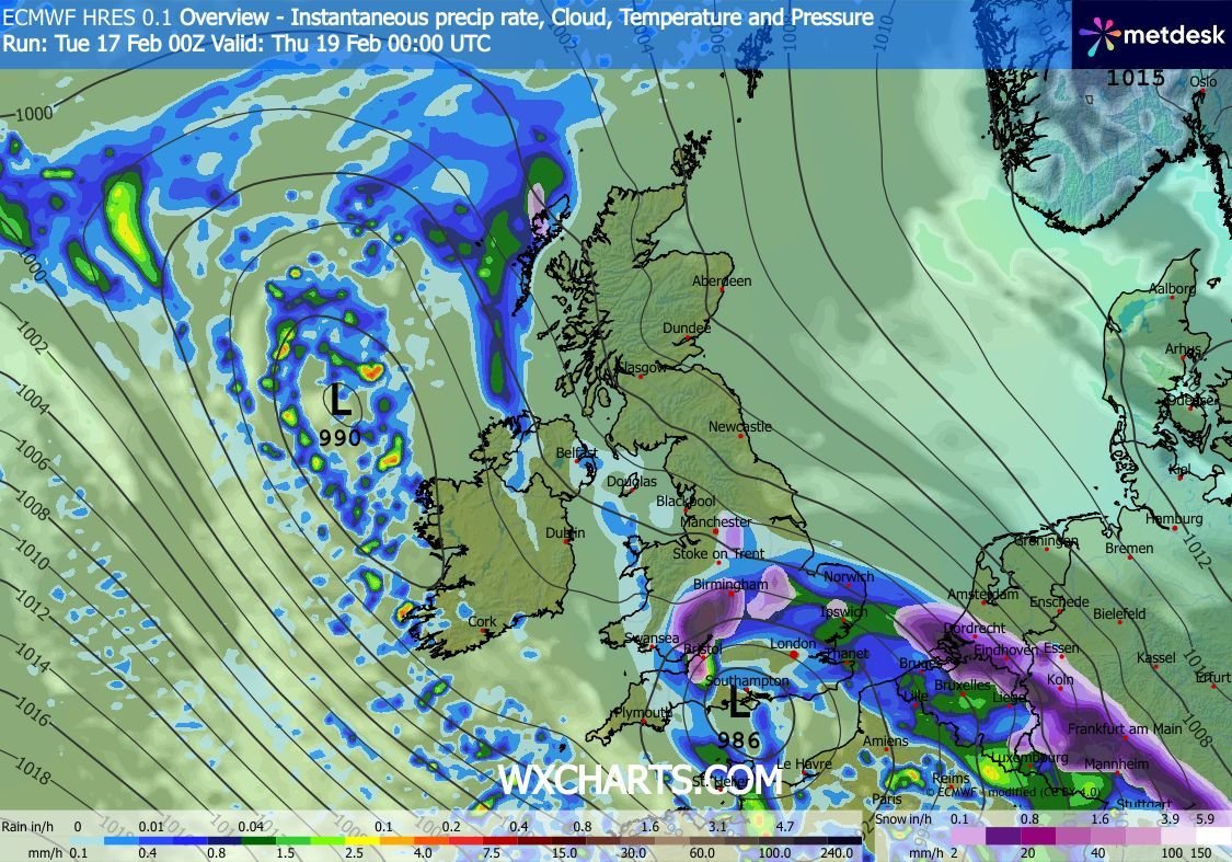
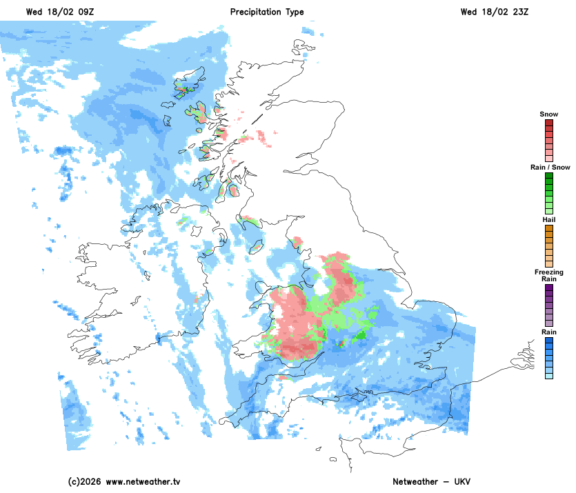
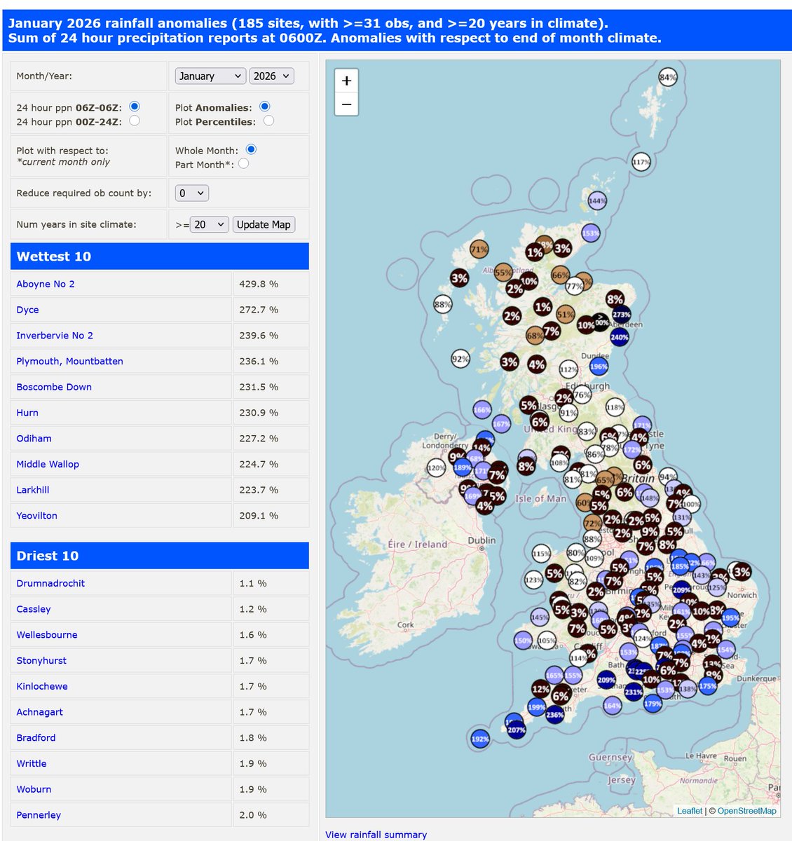
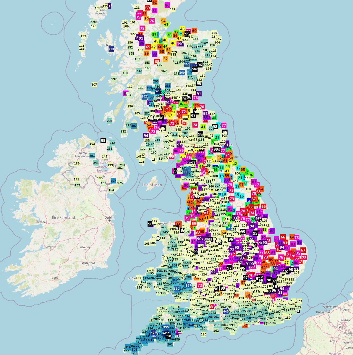
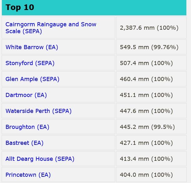
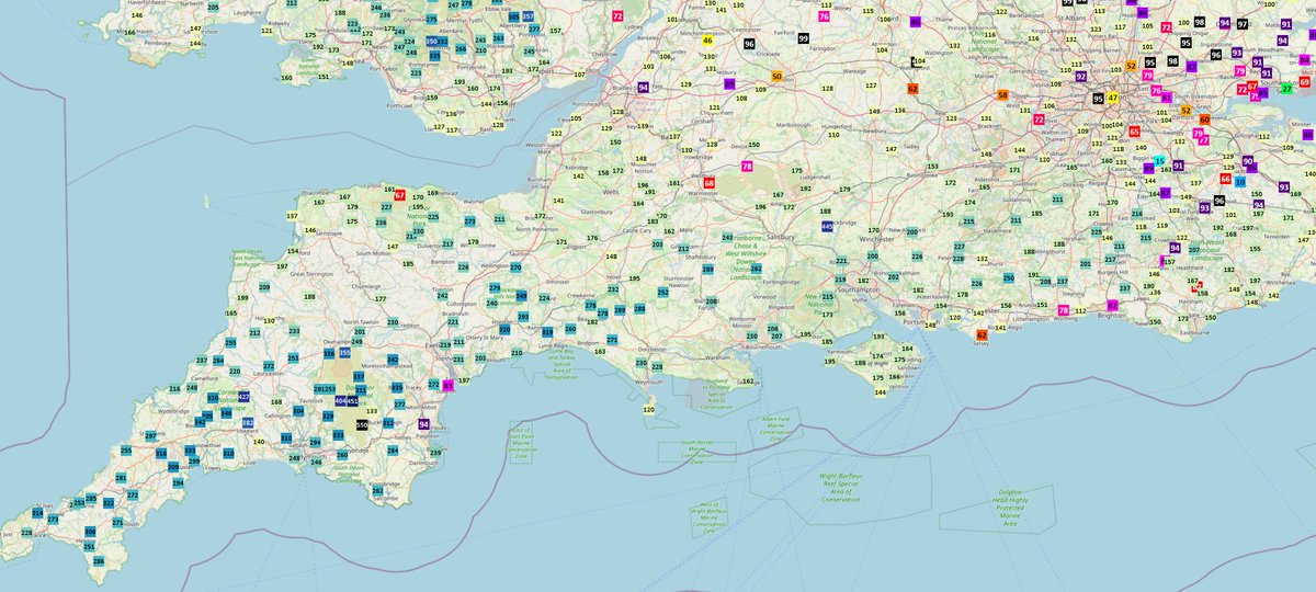
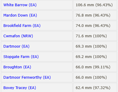
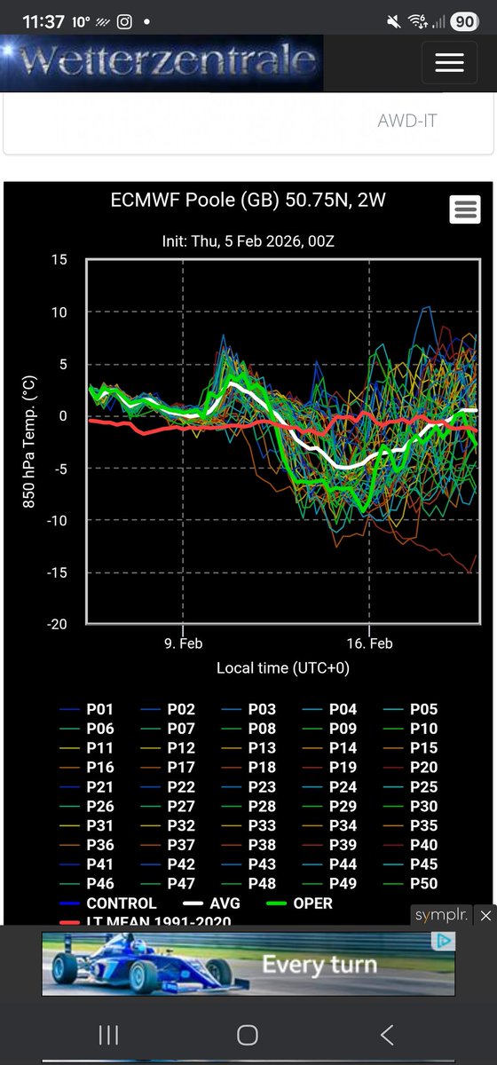
February 2026: Very wet (again) with more than twice the normal rainfall, and very mild. Full details on my blog at bhweather.com
English
0
1
1
99
Jim Smith BHWeather.com
Jim Smith BHWeather.com@BournmthWeather·
@afcbpodcast Think we'll lose this. West Ham always seem to find a way against us these days.. usually through a very marginal or wrongly applied VAR call. They also came very close to beating a bang-in-form Man Utd side a couple of weeks ago. Not relegation form ATM. Hope to be wrong.
English
0
0
0
61
Back Of The Net 🍒
Back Of The Net 🍒@afcbpodcast·
West Ham have improved, but fans remain agitated. ❌ Still in drop zone ❌Recruitment under fire ❌Crap stadium youtu.be/1vtxnC3wMZc Simon Jordan says #whufc fans are "crazy" to be expecting better. Is he right?!🤷‍♂️ And can Bournemouth make their problems worse? 😳 #afcb
YouTube video
YouTube
English
2
0
11
2.4K
Jim Smith BHWeather.com
Jim Smith BHWeather.com@BournmthWeather·
@afcb_J To have a chance, we need to break that Brentford hoodoo week after next. They always seem to beat us these days.
English
1
0
0
3.4K
J
J@afcb_J·
I genuinely believe this is our best ever chance to sneak into Europe. Everton are in a false position. Brentford are in a false position. 7th & 8th will be conference and europa. Is this our season? #AFCB
J tweet media
English
99
2
191
114.3K
Jim Smith BHWeather.com
Jim Smith BHWeather.com@BournmthWeather·
@PaulBlight6 Indeed. Part of Harewood Avenue is flooded to a depth of up to several inches. I've never seen that before in 50 years.
English
0
0
1
17
Jim Smith BHWeather.com
Jim Smith BHWeather.com@BournmthWeather·
Current rainfall for this year still running at more than twice the normal levels - 232% as of today and it's still raining. The average for whole of February is 64.8mm, this month 109.8mm, so almost twice the normal rainfall with 10 days still to to go
English
1
0
2
378
James Peacock
James Peacock@peacockreports·
Had the low split away eastward more quickly, a cold air undercut from the northeast would have brought snowfall to quite low elevations. Instead, it may be that snow doesn't get below 200 m or so ASL. The far south of England may see 15-20 mm rain - very unhelpful!
English
1
0
4
933
James Peacock
James Peacock@peacockreports·
Seems the southern scenario that the Met Office favoured isn't going to play out tomorrow. The low spends a little too long interacting with the one just west of Ireland, which causes it to move northward while wrapping in less cold air from the southeast. Tight margins matter.
James Peacock tweet mediaJames Peacock tweet media
English
4
1
23
3.4K
Met4Cast - UK Weather
Met4Cast - UK Weather@Met4CastUK·
Teleconnections performed as expected this winter. Pressure anomalies for winter show a south shifted jet and lots of blocking. What teleconnections can do is give you a broad idea of expected patterns, going into winter blocking was more likely than normal and zonal patterns were less likely than normal, that has come very much to fruition. What they can’t do, and what people like you seem to ignore either deliberately or through ignorance is telling you what weather will be doing in X location. In terms of teleconnections, long range forecasts on the broad scale have been spot on. Regionally, i.e the UK, is always going to be more difficult and impossible to pin point detail.
Met4Cast - UK Weather tweet media
English
4
2
30
3.4K
Met4Cast - UK Weather
Met4Cast - UK Weather@Met4CastUK·
After all the hype. The promises. The precipitation GFS charts. It’s a Welsh hills & Peak District snow “event”. One day some might learn not to take precipitation GFS charts so literally! More rain for most ☔️
Met4Cast - UK Weather tweet media
English
11
3
58
7.9K
MET MATT🥶
MET MATT🥶@MATTYWOLVES3·
@Met4CastUK Red flags ffs! Are you a life guard or something? Those red flags need shoving sideways up your rear end!
English
2
0
7
1.4K
Jim Smith BHWeather.com
Jim Smith BHWeather.com@BournmthWeather·
@liamdutton Wettest Jan day this century here, and the resulting flooding. Also the run of air pressure remaining < 1000hPa (bar a short spell of a few hours) since late on 20th Jan, and looks set to continue till at least Thurs. As I said in my blog on my site, quite unusual for down here.
English
0
0
1
42
Liam Dutton
Liam Dutton@liamdutton·
After a dry and cold start to January, it then turned persistently wet and often windy, leading to saturated ground and flooding in some parts of the UK. What was the most memorable aspect of the weather for you this January?
English
9
2
6
2K
Liam Dutton
Liam Dutton@liamdutton·
JANUARY WEATHER STATS Whole UK ☔️rainfall 17% above avg 🌡️mean temp 0.5C below avg ☀️sunshine avg ▪️wettest Jan on record for Cornwall & County Down ▪️2nd wettest Jan for N. Ireland ▪️6th wettest Jan for S. England ▪️ 3 named storms - Goretti, Ingrid and Chandra
Liam Dutton tweet media
English
2
2
13
2.6K
Jim Smith BHWeather.com
Jim Smith BHWeather.com@BournmthWeather·
@PaulBlight6 @RoostWeather Jan record (this century) 198.2 in 2014. Mean here is 83.4 (probably a little higher once this year is taken into account.) My records go back to 1996, but at this location from 2000 after I moved.
English
0
0
1
14
Paul Blight
Paul Blight@PaulBlight6·
January was a very wet month across many parts of the UK . We should have more complete data by Monday , but early suggestion Anomaly Maps from @RoostWeather Dan Harris show big anomalies from North to South. Hurn near Bournemouth we ended up at 231% of the norm . Plymouth , Boscombe Down and Hurn all at around 230-240% of normal. (some figures are clearly not available yet) Figures on the right 09Z 1/1 to 09Z 1/2 Whitebarrow on Dartmoor seeing an absolutely stonking 22 Inches of Rain, or 550mm of rain. Princetown and Other Dartmoor Gauges seeing 16-18 Inches of rain. Aldnerney Near Poole/Bmth Border receiving 9.2 Inches of Rain or 230mm . These figures must be close to the wettest January on record in parts of Dorset. @peacockreports @RoostWeather @BournmthWeather
Paul Blight tweet mediaPaul Blight tweet mediaPaul Blight tweet mediaPaul Blight tweet media
English
7
10
27
6.2K
Jim Smith BHWeather.com
Jim Smith BHWeather.com@BournmthWeather·
< and looking at fcast charts, v likely to remain so till at least Thurs. This looks set to be the longest period of such low pressure this century. More on bhweather.com later when I update the blog
English
0
0
0
87
Jim Smith BHWeather.com
Jim Smith BHWeather.com@BournmthWeather·
January - 2nd wettest this century with 176.6mm - 211.7% of the normal for Jan. Temps slightly up on average - mean 6.7°C (+0.5c). A note about the air pressure.. since 21st Jan, the barometric pressure has been below 1000hPa almost continuously (bar a few hrs max 1001.4) cont>
English
1
0
0
130
Jim Smith BHWeather.com
Jim Smith BHWeather.com@BournmthWeather·
@patriciaasmit16 Yes, Zhongyi showed Alice's pics on FB earlier! Not a surprise, to be honest, I could see how high the water was last week.
English
0
0
0
16
Jim Smith BHWeather.com
Jim Smith BHWeather.com@BournmthWeather·
35mm of rain overnight (over an inch and a half). Expecting to hear of a lot of flooding locally. The bulk of the rain has now cleared, the threat of showers remains.
English
1
1
1
251
Jim Smith BHWeather.com
Jim Smith BHWeather.com@BournmthWeather·
@PaulBlight6 237% Need to go through my numbers at some point and see what the wettest month was in % of normal terms. Never done that.
English
1
0
0
20
Paul Blight
Paul Blight@PaulBlight6·
maximum Gusts (aside from mountains) 81 mph Orlock Head 76mph Isles of Scilly 74mph Plymouth 74mph St Bees Head 67mph Berry Head Rainfall has been extreme . 28 hrs from 09z on 26th to 13Z on 27th , 107mm at Whitebarrow , 74mm near ottery in East Devon. For the month, Whitebarrow now on 18.64 inches for the month , the area in the SW and south above 8 inches has now expanded up towards Salisbury Bournemouth now on around 174mm or nearly 177% of normal, with more rain expected we are likely to end on around 200% of normal, Why reservoir levels in the SW are quite so low is quite baffling.
Paul Blight tweet mediaPaul Blight tweet mediaPaul Blight tweet media
English
3
3
19
2K