
Ed Piotrowski

114K posts

Ed Piotrowski banner
Ed Piotrowski

Ed Piotrowski

@EdPiotrowski

Chief Meteorologist for WPDE ABC-15. Amateur photographer. N.C. State grad. 7x EMMY Nominated. 0 wins 😀

Myrtle Beach, SC Katılım Mart 2009
1.8K Takip Edilen63.6K Takipçiler
Ed Piotrowski
Ed Piotrowski@EdPiotrowski·
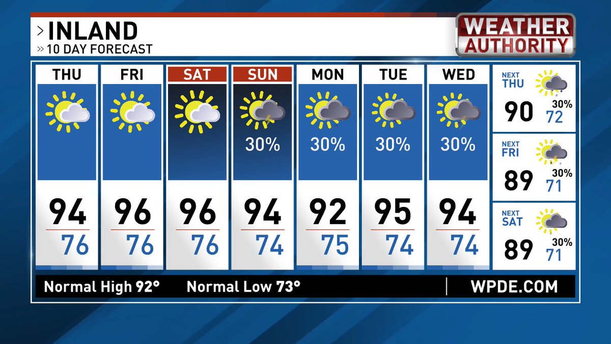
Plenty of heat and humidity with very few storms through Wednesday. A cold front approaches and stalls nearby for Thursday through Saturday, so it won't be as hot and there will be a better chance of showers and storms. Even with the increase in storms, no one day is a washout!
Ed Piotrowski tweet mediaEd Piotrowski tweet mediaEd Piotrowski tweet mediaEd Piotrowski tweet media
English
0
2
32
1.9K
Ed Piotrowski
Ed Piotrowski@EdPiotrowski·
TROPICAL DEPRESSION TWO FORMS 12:30 PM SUNDAY 7/19/2026 Low pressure in the eastern Gulf has become organized enough to be upgraded to Tropical Depression Two. While bouts of wind shear, dry air, and its proximity to land should prevent rapid strengthening, it is still expected to become Tropical Storm Bertha within the next day or two. The depression is moving slowly to the north-northwest. As high pressure builds along the Southeast coast, it will steer the system on a more westward track near or across the Gulf Coast states, from Florida to Texas. Given our ongoing rainfall deficit, a weak tropical system is exactly what we need. Unfortunately, this one is moving away from the Carolinas, so we won't see any rain from it. That doesn't mean we'll stay completely dry. We'll still have opportunities for scattered showers and thunderstorms throughout the week, with rain chances increasing a bit toward the end of the week as a front approaches. Even with the higher rain chances, no day looks like a washout. That's pretty difficult to achieve here in the middle of summer unless a tropical system is directly impacting the area.
Ed Piotrowski tweet mediaEd Piotrowski tweet mediaEd Piotrowski tweet mediaEd Piotrowski tweet media
English
3
7
42
4.2K
Ed Piotrowski
Ed Piotrowski@EdPiotrowski·
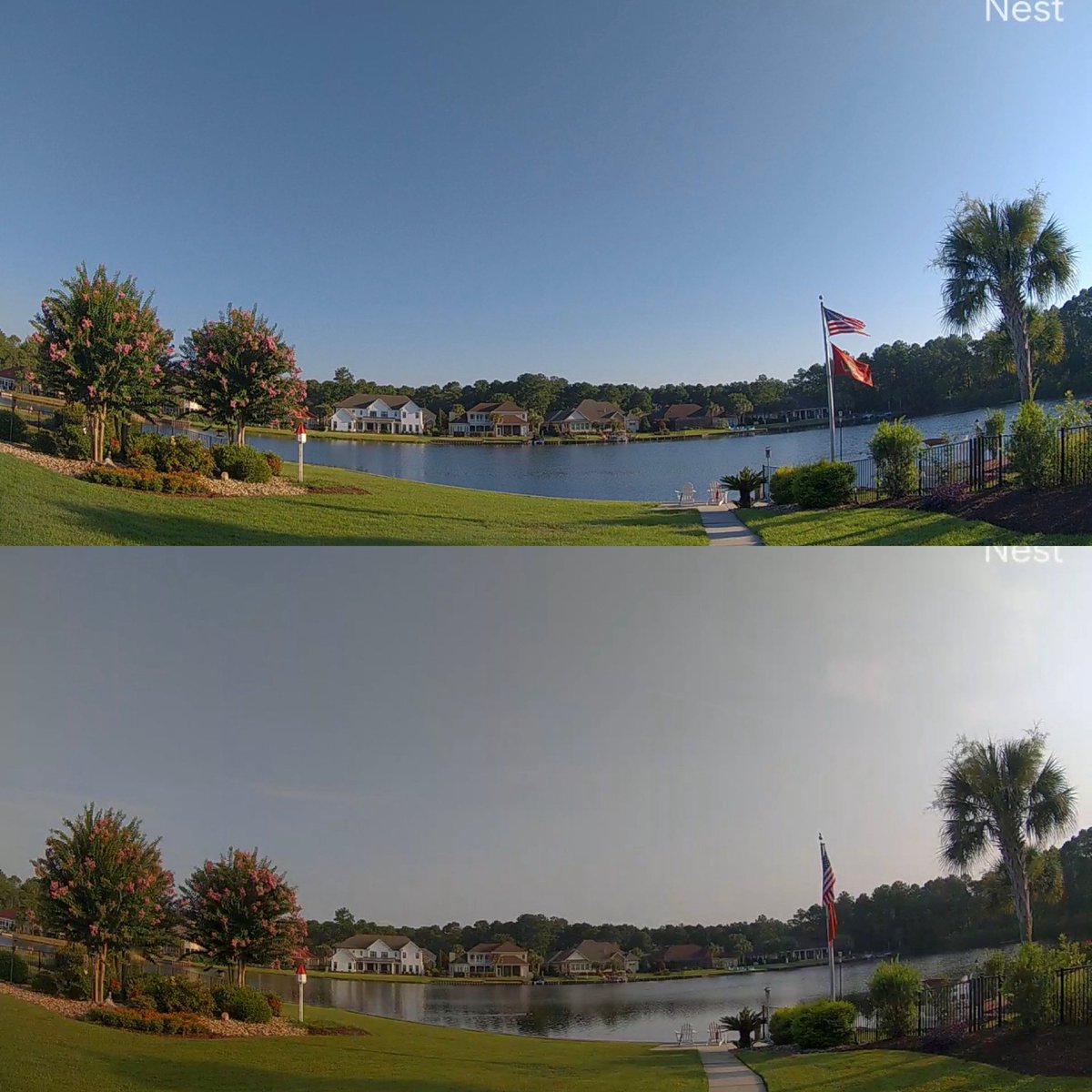
If you noticed the hazy sky this morning, you’re not imagining it. Some smoke from the Canadian wildfires has drifted into our area, reducing air quality slightly. If you’re highly sensitive to smoke or have respiratory issues, it may be a good idea to limit time outdoors today. Below are two images from the camera in my backyard. The top photo was taken at 8:00 am yesterday, and the bottom photo was taken at 8:00 am today. You can easily see the haze in the sky.
Ed Piotrowski tweet media
English
1
5
64
2.6K
Ed Piotrowski
Ed Piotrowski@EdPiotrowski·
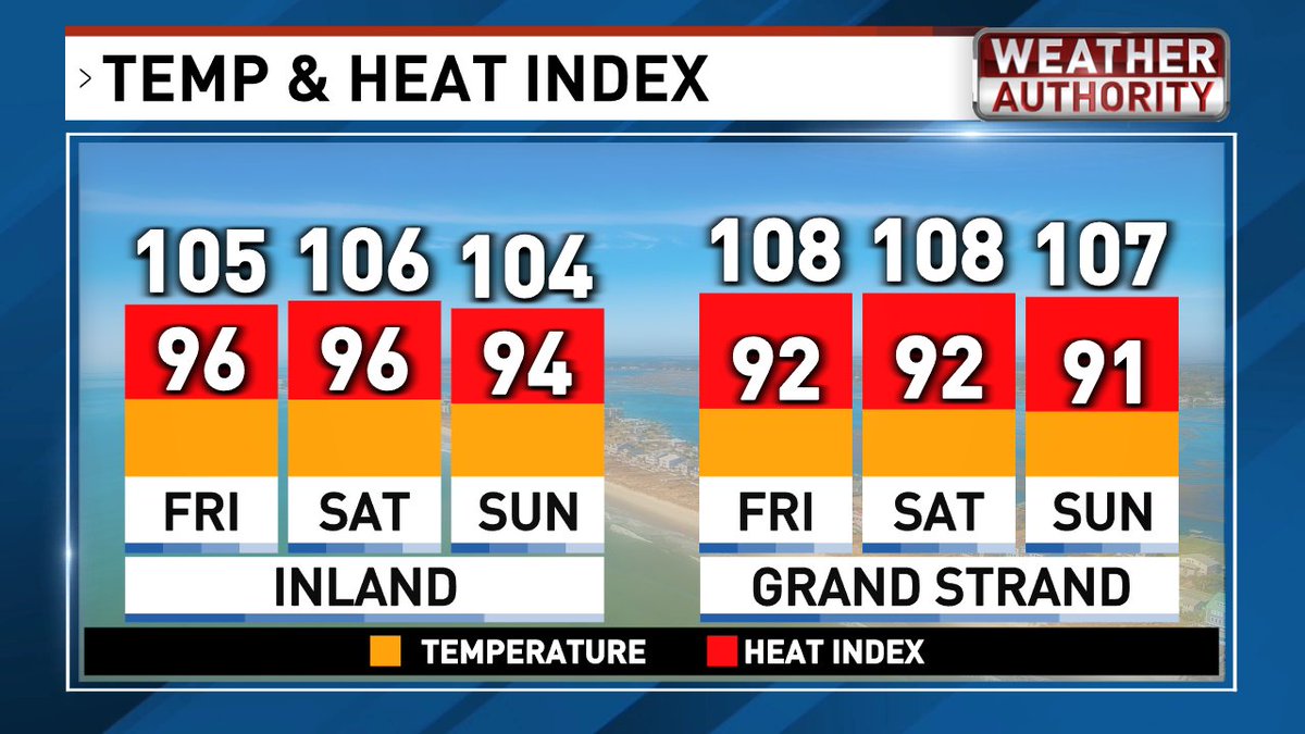
Hot and humid conditions will continue through the weekend, with afternoon highs in the low to mid 90s. When you factor in the humidity, it'll feel more like 103° to 108° both Saturday and Sunday. Rain chances remain low on Saturday, with only a slight chance of a few afternoon thunderstorms, mainly inland. The risk of severe weather is very low. By Sunday, the coverage of afternoon thunderstorms increases, again mainly inland. While most storms will be typical summertime storms, one or two could become strong enough to produce damaging wind gusts. Be sure to stay weather aware if you have outdoor plans Sunday afternoon. While we may see a better chance of storms toward the end of the week, they will be scattered so no washouts!
Ed Piotrowski tweet mediaEd Piotrowski tweet mediaEd Piotrowski tweet mediaEd Piotrowski tweet media
English
0
3
44
3.8K
Ed Piotrowski
Ed Piotrowski@EdPiotrowski·
Tonight I stepped outside to clear my head and witness the crescent Moon and brilliant Venus hanging low in the western sky. What a beautiful sight! The soft glow illuminating the dark side of the Moon is earthshine. Its sunlight reflected off Earth’s surface, bouncing back to gently light the Moon’s night side. I captured this image from backyard with my iPhone 17.
Ed Piotrowski tweet media
English
6
10
100
3.9K
Ed Piotrowski
Ed Piotrowski@EdPiotrowski·
Turning up the heat and bringing down the rain chances for the rest of the week. The chance for a few showers and storms will go up a bit Sunday into next week, but activity will be widely scattered so many won't get rain.
Ed Piotrowski tweet mediaEd Piotrowski tweet mediaEd Piotrowski tweet mediaEd Piotrowski tweet media
English
1
5
30
3.5K
Ed Piotrowski
Ed Piotrowski@EdPiotrowski·
TROPICAL UPDATE WEDNESDAY 7/15/26 AREA 1 - A tropical wave near Africa has a very low chance of developing over the next couple of days. After that, increasing wind shear and drier air should put an end to any additional development. This system poses no threat to the United States. AREA 2 - An area of low pressure is expected to develop in the upper levels of the atmosphere this weekend. There is a small chance it could gradually work its way down to the surface and become a tropical system. Because of its close proximity to land, moderate wind shear, and occasional intrusions of dry air, the National Hurricane Center gives it only a 20% chance of development. If a system does form, it could move just offshore of the Southeast coast or westward into the northern Gulf early next week. It's still too early to determine whether it could increase our rain chances, but there are currently no signs that, if it develops, it would become a strong tropical system.
Ed Piotrowski tweet media
English
1
7
51
8.5K
Ed Piotrowski
Ed Piotrowski@EdPiotrowski·
The payload from yesterday’s rocket launch was successfully deployed. This morning over Marlboro County there was a string of lights crossing the sky. That’s the newly released chain of Starlink satellites.
Ed Piotrowski tweet media
English
0
8
63
2.8K