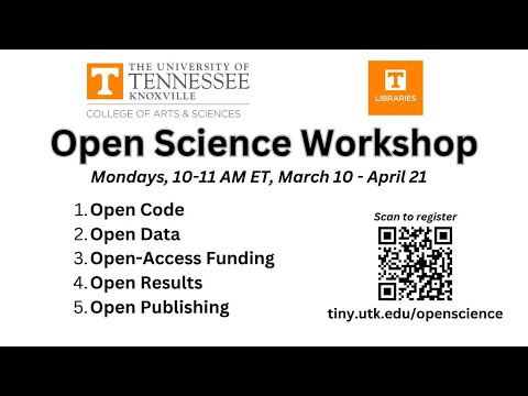
Geethen

197 posts

Geethen

Geethen

@Geethen1

Postdoc @Stellenboschuni university. Interested in applying AI to spatial data to address ecological challenges since 2017. [email protected]

South Africa Katılım Mayıs 2020
269 Takip Edilen157 Takipçiler
Geethen retweetledi
Geethen retweetledi
Land & Carbon Lab
Land & Carbon Lab@landcarbonlab·
🚨 UPDATE: Version 1.1 of the Natural Lands Map now includes cutting-edge grassland data, filling a critical gap in how companies track their impact. ➡️ Learn more: bit.ly/4k3jLEa ➡️ Explore the data: bit.ly/4b6l6pv
Land & Carbon Lab tweet media
English
0
6
18
1.1K
Geethen
Geethen@Geethen1·
@TimDarcet A very detailed video explanation😂. Was that intentional?
English
0
0
3
64
TimDarcet
TimDarcet@TimDarcet·
Empirically: using a direct loss is weaker, the iBOT loss does not work alone, using a linear student head to predict the CAPI targets works better than a MLP head. So we use exactly that.
TimDarcet tweet media
English
1
0
23
4.2K
Geethen
Geethen@Geethen1·
@DrKJoyce @spatialthoughts I recently saw a post on the GEE developers group were others also mentioned the same server performance issues from Nov 13. Perhaps check there to see any updates (assuming this is a related issue).
English
1
0
1
32
Dr Karen Joyce
Dr Karen Joyce@DrKJoyce·
@spatialthoughts Yep, all that is done, but it's still choking. And these are not big scripts - just a basic supervised classification of a single S2 image. Do you know if there is somewhere that we can see if it's thinking it's commercial or something and so throttling it?
English
1
0
0
33
Geethen retweetledi
Ribana Roscher
Ribana Roscher@RibanaRoscher·
🚨Our new review paper "Better, not just more: Data-centric ML for Earth Observation" 🌐🤖🛰️🔍 has finally been published in GRSM. Shifting the focus from models to data offers new possibilities to improve accuracy, generalization, and real-world impact: ieeexplore.ieee.org/document/10740… Joint work with @MarcCoru, Caroline Gevaert, @MKampffmeyer, @jeferssonalex, @MariaVakalopou1, @RonnyHaensch, Stine Hansen, @Keiller, Jonathan Prexl, @devistuia Arxiv version: arxiv.org/abs/2312.05327
Ribana Roscher tweet media
English
0
16
57
6.1K
Geethen retweetledi
Ujaval Gandhi
Ujaval Gandhi@spatialthoughts·
New Post: Tiling Large Exports in Google #EarthEngine with best practices on creating perfectly aligned mosaics from large images - featuring advanced concepts around projections, crs transform, resampling and nodata masks spatialthoughts.com/2024/10/23/lar…
GIF
English
0
17
103
4.5K
Caleb Robinson
Caleb Robinson@calebrob6·
1/ We released Fields of the World (FTW)-- a new satellite imagery + field boundary dataset with samples from 24 countries (now downloadable via torchgeo)! One cool part of this work is that we find that models trained on FTW have decent zero-shot performance in new locations:
Hannah Kerner@hannah_kerner

I'm so excited to finally introduce Fields of The World (FTW!) - the largest & most diverse ML dataset for field instance segmentation in satellite images. FTW has >70k samples from 24 countries (4 continents), with semantic & instance labels + Sentinel-2 RGB-NIR from 2 dates. 🧵

English
1
19
71
5.9K
Nathan Ruser
Nathan Ruser@Nrg8000·
Okay folks, strap in for a very technical question that maybe one or two people can help me with (maybe @SatelliteSci?), but is confusing and irritating the heck out of me. In Google Earth Engine. I am trying to map 'intertidal' areas by: 1. Calculating NDWI values 2. Converting those into a water mask 3. Averaging the mask values over a time period to show persistent land as values close to 0, persistent land close to 1 and areas of variance as values in between. (a simplified version of the method used by doi.org/10.3390/rs1410…) This all works, but my problem comes in step 2. I have tried 2 different ways to do this, one using a updateMask / unmask function and one using a where function (highlighted section of code in the screenshot). Theoretically, these should do an identical thing (ie check if a value is above a threshold if so make it 1, if not make it 0). However, the 'updateMask / unmask' function (top graph) gives clean masks for land areas but very noisy masks for water areas, but the 'where' function (bottom graph) gives a clean mask for water areas but a noisy mask for land areas. And this is confusing the hell out of me. Does anyone have any idea why these theoretically identical functions have drastically different results? This is my full script for reference: code.earthengine.google.com/f049b5131f5c79… And any tips on how to get a clean mask for both water and land areas?
Nathan Ruser tweet media
English
4
3
12
8K
Geethen retweetledi
Aravind 🌍 🛰
Aravind 🌍 🛰@aravindEO·
The Sentinel-2C satellite that should be launched tonight is expected to replace the Sentinel-2A satellite, which is, as far as I know, a perfectly healthy mission that is still performing well more than 9 years after launch. However, why should a successful launch of Sentinel-2C lead to the decommissioning of a functioning Sentinel-2A satellite? If S-2A is not shut down, it would mean that for the first time ever, we will have three Sentinel satellites in orbit, which should significantly increase the revisit time of the Sentinel constellation (currently once every five days to twice every five days). This has benefits across applications such as land cover classification, crop yield forecasting, disaster management, and several other use cases with societal, economic, and environmental impacts. Are these benefits not worth the few million euros per year required to keep Sentinel-2A operational for as long as possible? Or are there other reasons besides cost that I am overlooking?
Aravind 🌍 🛰 tweet media
English
3
22
102
6.9K
Geethen
Geethen@Geethen1·
@sherwang Thanks for the heads up :). Since the oloffson method and PPI produce similar results for area estimation, when (in practice) would you suggest using one approach over the other?
English
0
0
0
22
Sherrie Wang
Sherrie Wang@sherwang·
Remote sensing maps need uncertainty quantification to ensure they can be used reliably for science & policy. Excited to share our preprint on methods to correct map biases and quantify errors, bridging the gap between map creation and use: arxiv.org/abs/2407.13659  🗺❓🧵 1/n
English
5
27
153
22.2K
Geethen retweetledi
Rafael Izbicki
Rafael Izbicki@rizbicki·
Our paper "Regression Trees for Fast and Adaptive Prediction Intervals," co-authored with @kuben45, @mpotto1 and @rbstern, is now published in Information Sciences! 🎉 We introduce Locart and Loforest to calibrate prediction intervals for regression with coverage guarantees. +
Rafael Izbicki tweet media
English
3
9
44
1.9K
NASAEarthdata
NASAEarthdata@NASAEarthData·
A new Global Urban Polygons and Points Dataset (GUPPD), v1 (1975 – 2030) is available at NASA' #SEDAC. This global dataset provides 123,034 urban settlements with place names and population for the years 1975-2030 in five-year increments. Learn more: go.nasa.gov/3WH8WxK
NASAEarthdata tweet media
English
2
22
111
8.2K
Geethen retweetledi
Stanford AI Lab
Stanford AI Lab@StanfordAILab·
arXiv -> alphaXiv Students at Stanford have built alphaXiv, an open discussion forum for arXiv papers. @askalphaxiv You can post questions and comments directly on top of any arXiv paper by changing arXiv to alphaXiv in any URL!
English
130
1.8K
7K
911.3K
Geethen retweetledi
Jeremy Howard
Jeremy Howard@jeremyphoward·
Announcing FastHTML. A new way to create modern interactive web apps. Scales down to a 6-line python file; scales up to complex production apps. Auth, DBs, caching, styling, etc built-in & replaceable and extensible. 1-click deploy to @Railway, @vercel, @huggingface, & more.
Jeremy Howard tweet media
English
167
671
5.1K
666.1K
Geethen retweetledi
Ujaval Gandhi
Ujaval Gandhi@spatialthoughts·
My take on the 'Anatomy of a Matplotlib Figure' for geospatial visualization. Check out the notebook that creates the plot using #matplotlib using fancyarrowpatch annotations. Feel free to use/adapt for your own teaching! #matplotlib-anatomy" target="_blank" rel="nofollow noopener">courses.spatialthoughts.com/python-dataviz…
GIF
English
0
19
97
4.2K