Eric Moss
2.5K posts

Eric Moss
@More_Moss_
Openness | Awareness | Conscientiousness Love of Nature. Biophilia. Continual Cultural Expansion. Entheogens. Health & Wellbeing. Green Buildings & Design.
Seattle Katılım Nisan 2010
159 Takip Edilen90 Takipçiler

March 2026 finished with an average temperature of 73.0°F here in Las Vegas.
Not only does this demolish the old March record of 66.7°F (2015), it is also warmer than any April on record here... #nvwx #VegasWeather
English

@Weather_West Completely my own opinion here, but the PNW heatdome had to be more anamoulous right? There were locations west of the cascade mountains that were encroaching on 120 if I remember correctly. That's just absurd for a moderate Pacific climate.
English

I agree. This event has been meteorologically astonishing, and its impacts will be felt long after it ends in terms of record low snowpack, sharply increased wildfire risk, and extreme low watershed runoff/streamflow into summer and beyond.
Nahel Belgherze@WxNB_
As the first reanalysis data become available, I think I can say with a fairly high degree of confidence that the March 2026 heatwave will go down as the most anomalously extreme heat event ever observed at any time of year in the southwestern U.S.
English

@hubermanlab @0xQuasark Leave it up to the scientists and branding firms
English

@NightSkyToday Is it possible it's already gone supernova...light just still making its way out here.
English

@elonmusk It goes both ways, woke and maga are extremes that are becoming normalized. The Guide to destroying the west is normalizing these extremes and making people on either side hate each other. We forget that we are of the same nationality, & at one point got along for the most part.
English

@CliffMass Other than the one big snow fall about two weeks ago hasn't the snowpack been melting off way earlier than normal - which would at least partially explain the full reservoirs?
English

Are Reservoirs are Now Full, Months Ahead of Time
cliffmass.blogspot.com/2026/03/are-re…
English

@RepBoebert It's strange that our country has people in positions of power based on influencer-like qualities, that maybe aren't the best aligned for these leadership positions?
English

@laramidian @edgarrmcgregor Isn't snow pack more important than annual rainfall at median, because the melting snow this replenish reservoirs through the summer months? If the snow melts out this early then reservoirs will drop rapidly?
English

@edgarrmcgregor The snowpack is about to get replenished and we are right on median precipitation for the year in California. Get your hysteric takes in now before people know about the upcoming storms


English

@wsdot_north @wsdot @wspd7pio @CityofBhamWA @BellinghamPD @whatcomsheriff @WhatcomCoPWA @Whatcomctygov @SkagitGov @WATruckingAssn @BCTruckDrivers I understand that people are upset however If you don't have geotechs involved there is a risk of road failures and even longer delays or closures in the future. It's a small price to pay for reassurance that the roads will remain usable for a long time to come.
English

UPDATE 3/22: Crews removed trees at the bottom of the slide Sunday along northbound I-5. This important step allows geotechs to see what's beneath to plan for stabilizing the slope & removing rock.
The process needs precision & we still can't estimate when we'll reopen.
(1/2)


WSDOT North@wsdot_north
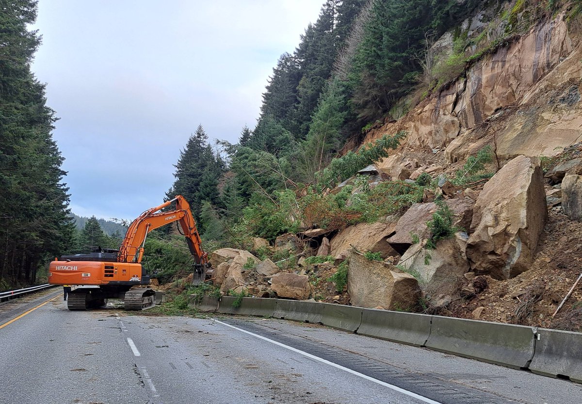
NB I-5 WORK BEGINS SUNDAY Emergency contract is signed & crews will begin clearing debris along south of Bellingham 3/22. Still no estimate when lanes will reopen, but crews will work 7 days a week. Safety of crews & travelers is our top priority. More: bit.ly/3PnDK5z
English

@SeattleWXGuy Thanks for posting and for all the weather content you provide regardless of the location. Some people on social media just like to look for trouble.
English

RARE, Flash Flood Emergency issued. Dire wording from the NWS Honolulu DAM FAILURE IMMINENT #hiwx #flood #flashflood


English

@US_Stormwatch I also use nws regardless of the circa 2003 website haha. However, if I remember correctly there are other sources of weather forecast that actually are more accurate based on % of correct forecasts?
English

The Weather App on your iPhone is awful (sorry, Apple).
I’ve seen tons of screenshots of the upcoming heatwave forecast, and the Weather App is off by up to 5-10 degrees. National Weather Service forecasts are the most accurate source, but unfortunately its website looks like it was built in 2003. @EverythingWX (not an ad) is the only app I know of that displays NWS forecasts in a great user interface.
If you are wondering why the Weather App’s forecasts are so inaccurate, it’s because it only uses select raw weather data without any trained meteorologists reviewing it. There are over 120 NWS offices across the US that issue fantastic forecasts using far more models and tools, with real humans reviewing the data.
Take the Weather App’s forecast for San Francisco, it’s only forecasting a high of 83°F on Tuesday, while the NWS is forecasting 88°F.
The NWS also uses a point forecast system where each grid square covers a 2.5 km × 2.5 km area, which more accurately captures microclimates, perfect for a city like San Francisco.
Use the NWS forecast this week and ditch the Weather App.

English

Ladies and Gentlemen, the 18Z GFS after hour 168
Interesting things@awkwardgoogle
The unpredictability of the double pendulum.
English

@WhidbeyWXGuy How many times in recorded weather history has this or a similar setup occured in mid March around here? I'm assuming close to 0 times. Never say never, however this is pretty close to that.
English

Some models are showing some sneaky snow potential on Friday morning as a weak low moves in under some moderately cold air. This low will be associated with a sharp atmospheric river/front, which makes the forecast VERY tricky. In the 2nd image, you can see how sharp that southerly wind boundary is. Basically, anywhere north of that boundary looks to have temperatures in the low to mid-30s. These surface temps could be just barely marginal enough to get a wet rain/snow mix or even full snow for the coldest areas. Currently, the most favored area for snow is the northern Puget Sound area up to SW BC. Current model solutions range from 0" of snow to upwards of 8" of snow depending on how low the temperatures get.
This will be a really tricky forecast that we need to closely monitor throughout this week! Especially since heavy, wet snow can cause power outages on top of the regular disruptions snow cause.


English

@WhidbeyWXGuy There's a less than 0% chance of this happening. It'll be mid March.
English

Just for fun, let's take a look at this afternoon's GFS model run. It brings a powerful storm in 9-11 days that brings a snowstorm, windstorm, AND a strong atmospheric river to the PNW. It drops over a foot of snow on Seattle before rapidly changing as strong winds (50-70mph) move warm air over the region leading to heavy rain and melting. I am curious to know, IF something like this were to happen, would you guys want it, or not? You can answer by voting in the poll below 👇
P.S. An active weather pattern looks to start up here soon, which I will have more posts about soon, but a solution like what the GFS is showing is VERY unlikely.


English


