Mo Smna
1.6K posts


Mo Smna
@OakSmoker
Infomation Technology Project Management.
Miami
Katılım Haziran 2011
311 Takip Edilen48 Takipçiler


Mo Smna retweetledi

Mo Smna retweetledi


Mo Smna retweetledi

I can't believe what I just witnessed... A Super Bowl ad promoting American patriotism and showing the Founding Fathers in a positive light.
America is uniting most magnificently. The woke train has derailed, and now it's time for people to learn to love America again.
God bless us all 🇺🇸🦅
English
@JohnMoralesTV Are there any impacts expected in South Florida. Concerned that it may restrengthen once it reaches the Golf of Mexico.
English

“A track over land not only weakens #Sara, but it sends its core further west towards a collision course with wind shear and dry air that’s expected to reach the western Gulf of Mexico at the beginning of next week.” nbcmiami.com/weather/hurric…
English
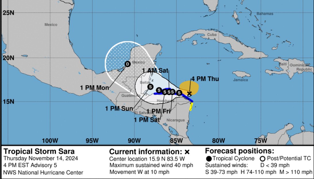
@tropicalupdate The storm is forecast to move inland over Belize on and quickly weaken while moving over the Yucatan Peninsula. This forecast shows dissipation by day 4, as the global models agree that the low-level circulation of Sara is unlikely to survive its trek across the Yucatan Peninsula
English

11/14 Tropical Storm Sara forms in the Caribbean. Lots of land interaction expected calling for system to dissipate in the Gulf. Some weather still heading to the SE/Florida midweek. #tropicalstorm #sara #tropicalupdate #florida #mikesweatherpage #mwp
Oldsmar, FL 🇺🇸 English
@PhilFerro7 The storm is forecast to move inland over Belize on and quickly weaken while moving over the Yucatan Peninsula. This forecast shows dissipation by day 4, as the global models agree that the low-level circulation of Sara is unlikely to survive its trek across the Yucatan Peninsula
English

10 pm Thursday Advisory and Cone on Tropical Storm Sara.
🔴Recon finds it inland along the Honduran Coast.
🔴5 to 10 , up to 15 inches of rain possible for parts of Cen. Am. & Mexico
🔴Forecast track now keeps it in Yucatan.

English
@BobbiStorm The storm is forecast to move inland over Belize on and quickly weaken while moving over the Yucatan Peninsula. This forecast shows dissipation by day 4, as the global models agree that the low-level circulation of Sara is unlikely to survive its trek across the Yucatan Peninsula
English

Well how bout that? 5 PM Discussion from NHC regarding #Sara sees her petering out over the Yucatan! (who had that on their bingo card??)
Thoughts??
English
@BobbiStorm The high pushing the storm was highly underestimated by many models. Question is why.
English

#Sara forms in Caribbean.
Name replaces “Sandy” from 2012.
English
Mo Smna retweetledi

Love this trend graphic from @burgwx -- it's a super ensemble of every major computer model averaged together. Each line is the average of them all over the last day, and notice the trend west (more land interaction in Honduras and Mexico) meaning weaker overall system.
Whatever remains or re-develops once in the Gulf (if it survives) looks like it will hook towards Florida mid-next week. Whatever "it" is at that point is highly unknown. We will watch data closely Thursday if anything trends back over water more meaning a stronger system.

English
@BobbiStorm Unfortunately don’t wish this to anyone BUT leaving in Florida………….
English
Mo Smna retweetledi

That's just the first line, and we have plenty of time to see all the models come in and where they eventually lead. I think my point here is, a lot of folks for click bait will jump on posting some early scary images without context, ignore those, it's too early to get focused on single outcomes.
English

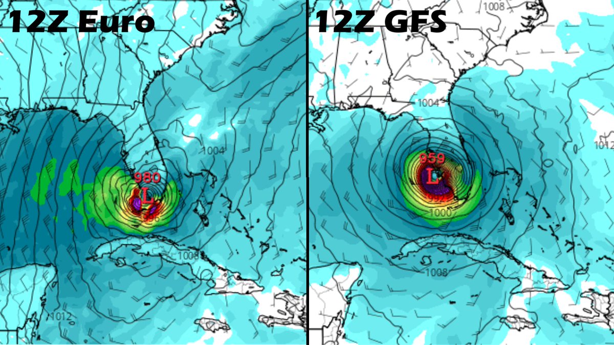
Striking resemblance between 12Z Euro & GFS—both showing #hurricane striking Gulf Coast of Florida next Wednesday. Does this mean it *will* happen for sure? Of course not. But models are coming into agreement on significant tropical-cyclone impact on FL Gulf Coast next week.
English
Mo Smna retweetledi
Regardless of what the calendar says, the atmosphere says it wants to develop another tropical system. And while certainty is high that we will have a tropical depression or storm in the western Caribbean by early next week, certainty is very low on where that system will go.
The majority of the global ensemble model runs through the next 7 days keep the developing system in the western Caribbean, and everyone in the Caribbean should keep a very close eye on it, possibly starting some types of preps by this weekend.
But for Florida, it's too early to tell what if any impacts are possible at this time. That means it's also too early to speculate, and too early to let anxiousness or worry take over.
If you have your hurricane kit & your hurricane plan, then you've done as much prep as is needed in Florida at this point in time. By this weekend, we will know if we need to start more rigorous preps, but for now, we watch and not worry.
GIF
GIF
GIF
English
Mo Smna retweetledi


Mo Smna retweetledi

Join us in congratulating Rosanna Cordero-Stutz on being elected Sheriff of Miami-Dade County!

English


@JohnMoralesTV What are the expected impacts for south Florida particularly for Miami-Dade if in any.
English
Tropical Depression Eighteen has formed in the western Caribbean south of Jamaica, where a Tropical Storm Warning is in effect. A Hurricane Warning is in place for the Cayman Islands and a Hurricane Watch for parts of Cuba. After Cuba, the Gulf presents a more hostile environment

English