SPARTANWEATHER95

11.7K posts

SPARTANWEATHER95 banner
SPARTANWEATHER95

SPARTANWEATHER95

@SPARTANWEATHER

Spartans Never Surrender.
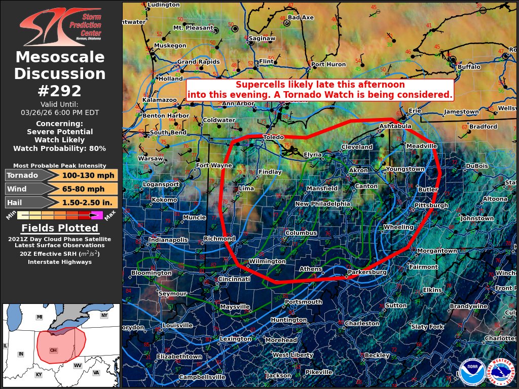
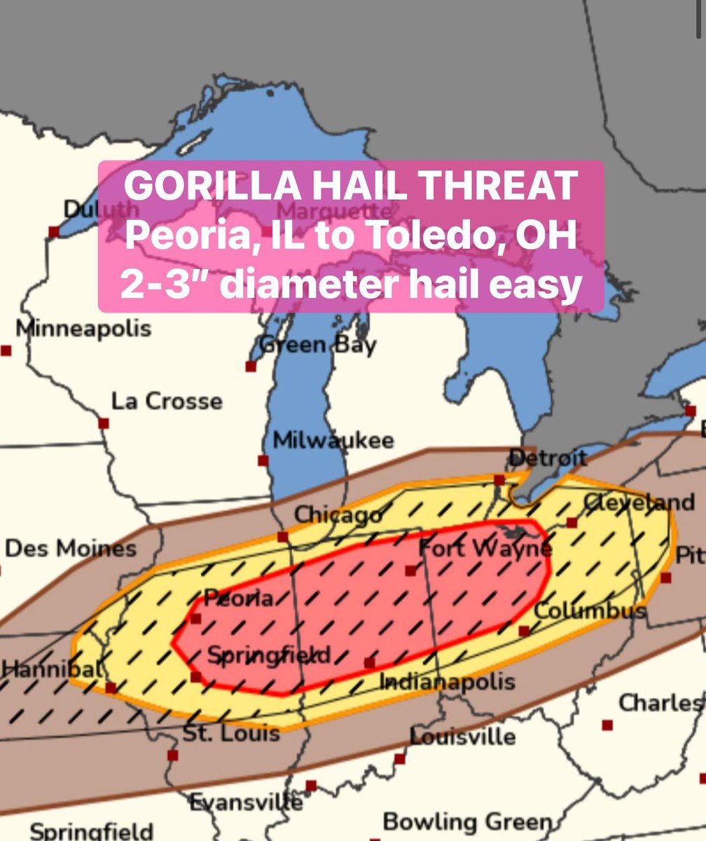
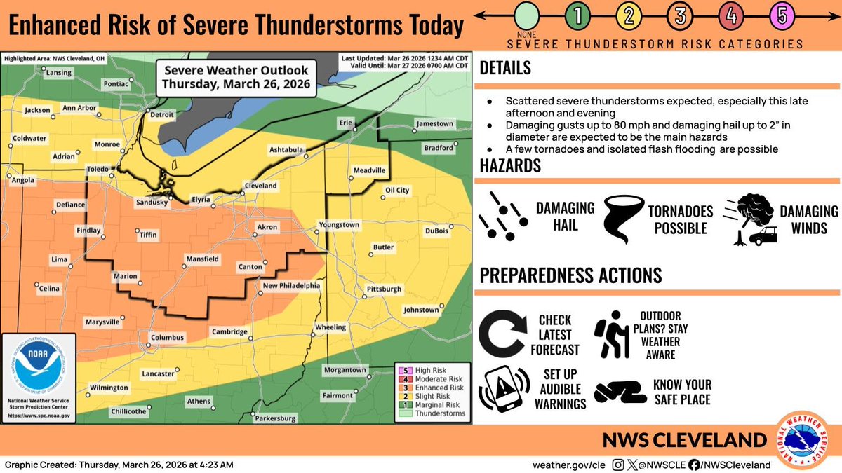
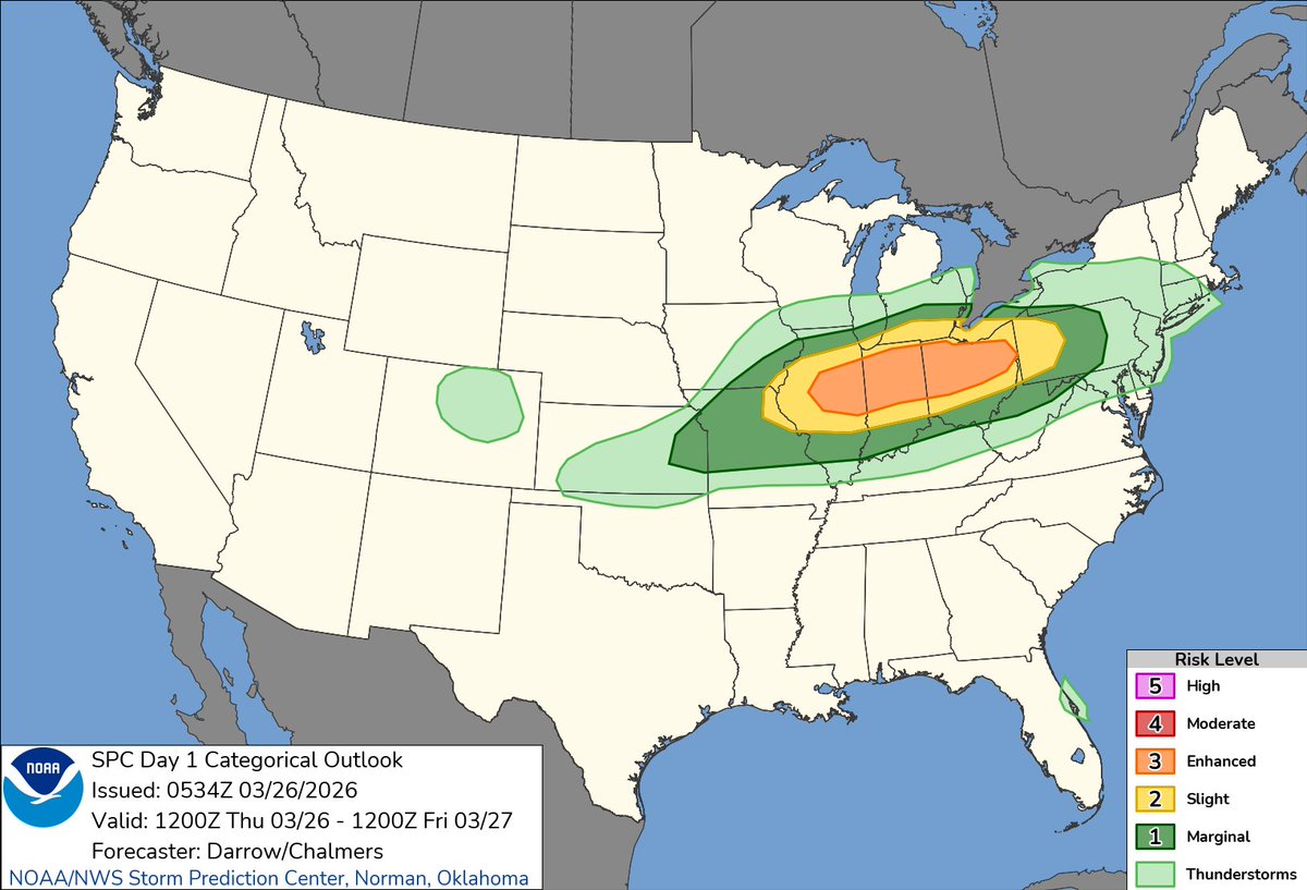
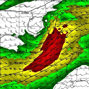
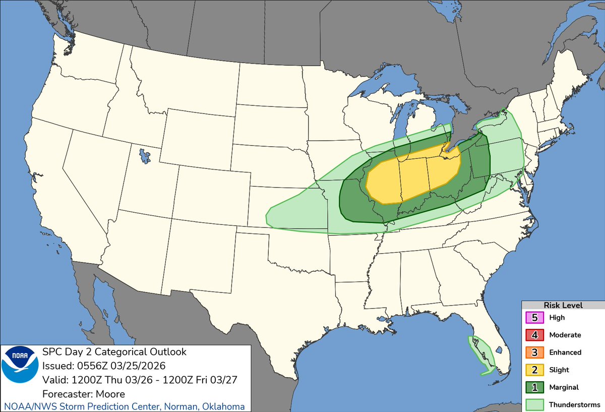
Findlay, OH Katılım Mart 2021
181 Takip Edilen102 Takipçiler
SPARTANWEATHER95
SPARTANWEATHER95@SPARTANWEATHER·
Wow! I have never seen lightning like this before. Literally non stop lightning and a constant roll of thunder in the storm going through Findlay Ohio right now.
English
3
0
2
99
SPARTANWEATHER95 retweetledi
Tyler Sebree ⚡️
Tyler Sebree ⚡️@TylerSebreezy·
Intense strong and severe thunderstorms will erupt late this afternoon and move southward through the evening. Most guidance shows the storms running into a wall at I-70 and weakening quite a bit. #OHwx
GIF
New Rome, OH 🇺🇸 English
3
3
22
2.8K
SPARTANWEATHER95 retweetledi
Reed Timmer, PhD
Reed Timmer, PhD@ReedTimmerUSA·
GORILLA HAIL THREAT maximizes today from Peoria, Illinois through Toledo, Ohio this late afternoon and evening! We expect elevated supercells to erupt by 4-6 pm across northern Indiana and expand across the enhanced risk zone. Any dominant supercells that can steamroll southeast into the warm air will have a chance of a #tornado or two, especially around 7-9 pm. We are activating storm chase mode
Reed Timmer, PhD tweet media
English
36
106
636
74.5K
SPARTANWEATHER95 retweetledi
NWS Cleveland
NWS Cleveland@NWSCLE·
4:29 AM EDT 3/26/26: Up to an enhanced risk (level 3 of 5) of severe t-storms exists in our region today. The most likely window for severe storms is late this afternoon into this evening.
NWS Cleveland tweet media
English
2
55
173
17.7K
SPARTANWEATHER95
SPARTANWEATHER95@SPARTANWEATHER·
@TylerSebreezy If it's none of the above it's the giant pot holes that are big enough to swallow a car or the orange construction cones LOL.
English
0
0
1
61
Tyler Sebree ⚡️
Tyler Sebree ⚡️@TylerSebreezy·
If it's not tornadoes it's hail. If it's not hail it's ridiculously cold. If it's not it's a meteor strike. Ohio is wild lol.
Lincoln Village, OH 🇺🇸 English
4
17
149
3.8K
SPARTANWEATHER95
SPARTANWEATHER95@SPARTANWEATHER·
@ImFromCle You don't have the correct graphic also the enhanced risk has been part of it for over 24 hours.
SPARTANWEATHER95 tweet media
English
0
0
1
211
I'm From Cleveland
I'm From Cleveland@ImFromCle·
A large storm system moving through the Ohio Valley could bring strong to severe storms into Northeast Ohio Thursday evening. Cleveland sits on the northern edge of the risk, but damaging winds, large hail, and a low chance for an isolated tornado are all possible between 6 PM and 1 AM. Forecast details may shift, so keep an eye on updates and make sure alerts are turned on.
I'm From Cleveland tweet media
English
4
11
51
16.4K
SPARTANWEATHER95 retweetledi
Convective Chronicles
Convective Chronicles@ConvChronicles·
SPC has maintained the Slight Risk (level 2/5) for tomorrow (March 26) from Illinois to Ohio, albeit shifted a tad north relative to the previous outlook. Supercells should develop along a southeast-moving cold front tomorrow afternoon, particularly across the Slight Risk corridor. All hazards, including large to very large hail and a couple tornadoes (perhaps strong), will be possible during this initial semi-discrete supercell phase. However, given deep-layer shear vectors generally parallel to the front, a relatively quick evolution into more of a line/line segments is expected, at which point the damaging wind risk will take over.
Convective Chronicles tweet media
English
4
20
96
5.2K
SPARTANWEATHER95
SPARTANWEATHER95@SPARTANWEATHER·
@ChrisJacksonSC To be fair it would be highly unusual to Issue a Day 2 High Risk. However it has happened before but that was with the old system. I think it's possible we see a upgrade later this afternoon or tomorrow morning.
English
0
0
6
661
☈ Chris Jackson ☈
☈ Chris Jackson ☈@ChrisJacksonSC·
Strong and possibly long track tornadoes (**plural**) are a CIG1 for tornado intensity..? Not to mention a widespread damaging wind event with a 60% contour on a D2 Outlook is also a CIG1 for wind..? If you want me to like this side of the CIG products, which I do in theory but I have questions with things like this… IMO need to reflect the actual risk. The graphic should always match the included discussion which imo the CIG groups do not match given the discussion. Maybe I’m looking into this too hard, idk. Not trying to nitpick. The discussion is great. Completely agree with it.
☈ Chris Jackson ☈ tweet media☈ Chris Jackson ☈ tweet media☈ Chris Jackson ☈ tweet media☈ Chris Jackson ☈ tweet media
English
9
10
118
12.9K
SPARTANWEATHER95
SPARTANWEATHER95@SPARTANWEATHER·
@Stupercell That's not true at all. Certain vehicles are aloud to have/use them so to say they are illegal is a fase statement. And each state and city has their own ordence regarding flashing/strobe lights on vehicles and most dont enforce it unless it's egregious.
SPARTANWEATHER95 tweet media
English
0
0
2
30
SPARTANWEATHER95 retweetledi
Tyler Sebree ⚡️
Tyler Sebree ⚡️@TylerSebreezy·
WILD WINDS FRIDAY: Boy, models are upping the ante for wind gust potential late Thursday night and Friday. Typically models are a little aggressive with wind gusts. But even if these numbers are adjusted down a little, they're still very impressive. #OHwx
Tyler Sebree ⚡️ tweet mediaTyler Sebree ⚡️ tweet mediaTyler Sebree ⚡️ tweet mediaTyler Sebree ⚡️ tweet media
Lincoln Village, OH 🇺🇸 English
1
5
28
2.4K