Mark Davenport retweetledi
Mark Davenport
16.8K posts


Mark Davenport
@TheDavenReport
Director of Content @weatherchannel | Big Ideas Only | Energy of 10,000 Golden Retrievers | #GoDawgs | #FTTB
Atlanta, GA Katılım Ağustos 2009
1.4K Takip Edilen3.7K Takipçiler

Mark Davenport retweetledi

Just 1,500 feet (457 m) from the Artemis II launch, we deployed our special high-resolution, slow-motion camera to record the blast-off in jaw-dropping detail at 2,000 frames per second. Find out how we did it: on.natgeo.com/0BXGmi
English
Moonbound! 🚀 If you missed any of the excitement and energy from the Artemis II launch last night… Look no further.
The @weatherchannel was live along the Space Coast to capture everything from countdown to liftoff! @NASA
English
Mark Davenport retweetledi

No this is not a joke…Retro Weather Channel is officially back! 🎶 Head to weather.com/retro enjoy RetroCast Now for your forecasts in the way you know and love. 💙🎷☀️
English
Mark Davenport retweetledi

America’s next leap is underway..
Godspeed Artemis II 🇺🇸

English
Mark Davenport retweetledi

Liftoff.
The Artemis II mission launched from @NASAKennedy at 6:35pm ET (2235 UTC), propelling four astronauts on a journey around the Moon.
Artemis II will pave the way for future Moon landings, as well as the next giant leap — astronauts on Mars.
English
Mark Davenport retweetledi

Mark Davenport retweetledi
Tomorrow, we launch.
At sunset tonight, Artemis II waits on the pad, ready to carry astronauts potentially farther than any humans have traveled in more than half a century.
The next era of exploration begins.
English
Mark Davenport retweetledi
The countdown begins.
Teams at @NASAKennedy have arrived to their stations at the Launch Control Center. We are about 48 hours from the launch of the Artemis II mission around the Moon. go.nasa.gov/4bHcwzx

English
Mark Davenport retweetledi

🚨#BREAKING: For the FIRST TIME in 540 days, Highway 64 in Bat Cave NC, which was destroyed during Hurricane Helene, has officially REOPENED to the public!!!
The highway connecting to Lake Lure was rebuilt $7 MILLION UNDER BUDGET and FASTER than expected.
Incredible!!!
English
Mark Davenport retweetledi
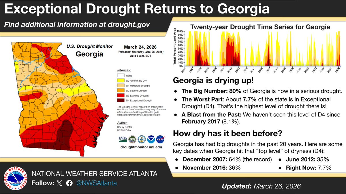
Did you know that Georgia is currently in its worst drought in nearly 10 years? The latest Drought Monitor shows 80% of Georgia in at least Severe Drought. Check out this graphic to see how this compares to other big Georgia droughts in the last 20 years. #gawx #GeorgiaDrought
English
Mark Davenport retweetledi
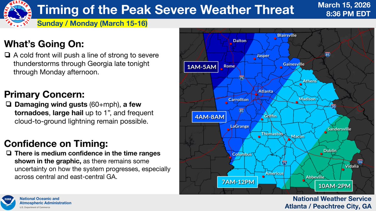
[Update 3/15 at 9:45 PM]
As the strong cold front approaches the area, a line of strong thunderstorms is expected to enter far northwest GA after 1 AM, continuing south and east through the morning and early afternoon.
Several storms within this line will likely be severe. (1/2)


English
Mark Davenport retweetledi

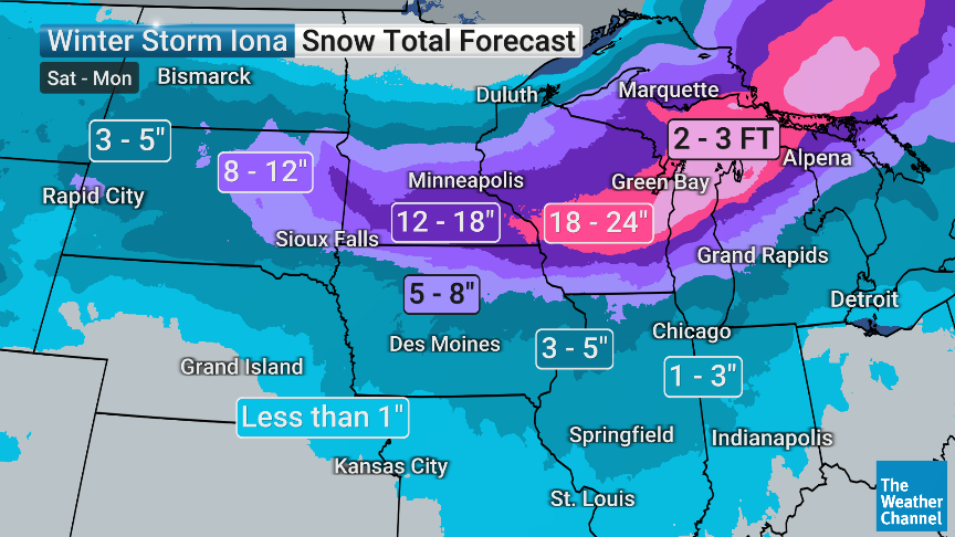
2nd Winter coming in strong across the Upper Midwest. That’s 2-3 FEET of snow from Wisconsin to Michigan. Rochester, The Twin Cities, Madison, Milwaukee, Green Bay, Traverse City…YOU READY?! @weatherchannel
English
Mark Davenport retweetledi


Mark Davenport retweetledi

** Aroma Park, IL Tornado Damage ***
🌪️ Absolute devastation from the violent tornado on 3/10/26 across the far south side of Kankakee, IL, into Aroma Park, IL. Homes were destroyed and wiped away, cars were flipped, metal was thrown everywhere, trees were debarked, and the tornado even left ground scouring with debris scattered into the Kankakee River. This is a catastrophic and heartbreaking scene as people search through what’s left of their homes. 💔⚠️
📩 For licensing: Curtislergner@gmail.com#KankakeeIL
#AromaParkIL #Tornado #ViolentTornado #TornadoDamage #StormDamage #IllinoisWeather #SevereWeather #ExtremeWeather #NaturalDisaster #BreakingWeather #StormChasing #WeatherNews #ILwx #DisasterResponse #CatastrophicDamage #TornadoAftermath #WeatherAlert #Heartbreaking #LicensingAvailable


English
Mark Davenport retweetledi
🌪️ Major tornado damage on the south side of Kankakee, IL — homes destroyed, cars flipped, and devastating damage left behind. This was a violent and dangerous storm. Please keep everyone affected in your thoughts and stay away from damaged areas. ⚠️🏚️🚗💥
Contact Curtislergner@gmail.com for licensing.
#KankakeeIL #TornadoDamage #IllinoisWeather #SevereWeather #Tornado #StormDamage #WeatherAlert #BreakingWeather #Disaster #StaySafe
English
Mark Davenport retweetledi

🚨 Crown Point, Indiana
Tornado sirens are sounding as powerful storms track just to our south. Thunder and constant lightning overhead right now as this dangerous system moves through northwest Indiana.
Radar is indicating a storm capable of producing a large tornado, large hail, and smaller vortices embedded within the circulation. Conditions remain extremely volatile across the region tonight.
Once it’s safe to do so, we’ll head south on I-65 to move into communities that may be impacted and assess damage.
Stay alert:
• Keep Wireless Emergency Alerts turned ON
• Make sure your phone is charged
• Know exactly where your safe place is if warnings are issued
I’ll have updates from the field as this unfolds.
More coverage ahead on @weatherchannel . 🌪️⚡
English
Mark Davenport retweetledi


Mark Davenport retweetledi

🌪️ Midday Severe Weather Update
The tornado threat has increased in parts of the Midwest and Mid-Mississippi Valley as we head into the afternoon and evening hours.
Some areas are now showing TorCon values as high as 7, indicating a significantly elevated tornado risk. The environment is becoming more favorable for strong to potentially violent tornadoes (EF-3+), especially across parts of Illinois, Indiana, and surrounding areas later today into tonight.
Storms developing along this corridor could also produce:• Damaging winds• Large hail• Fast-moving tornadoes
Remember, TorCon is measured on a scale from 1–10, and if there is a number, there is a threat. A TorCon 7 represents a increased tornado potential, meaning conditions strongly support tornado development.
⚠️ Preparation is critical today:• Know where your safe place is• Have multiple ways to receive warnings• Be ready to act quickly if warnings are issued
📺 Our teams are tracking this dangerous setup closely. Stay tuned to @weatherchannel as we continue bringing you the latest forecasts and live storm coverage.
#SevereWeather #TornadoThreat #TorCon #StormAlert


English
Mark Davenport retweetledi
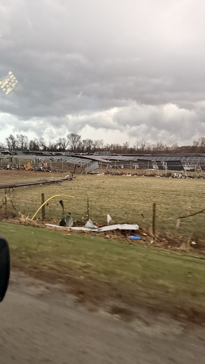
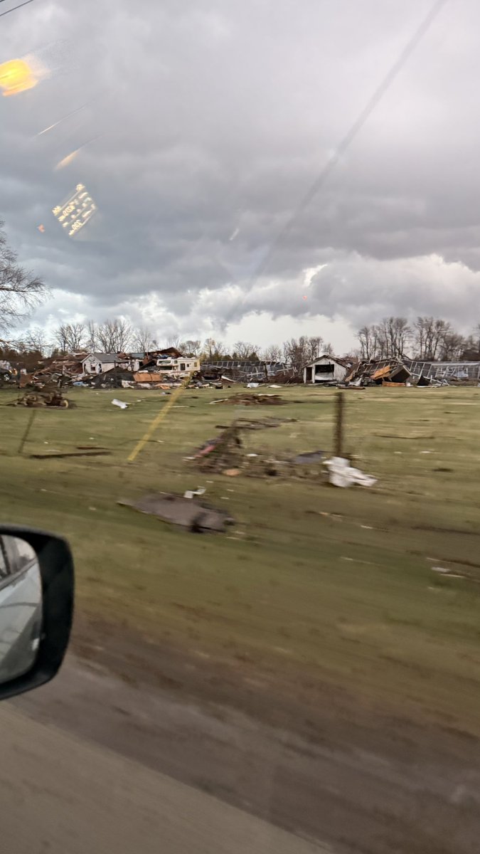
Union City, Michigan: An EF-3 tornado with winds near 150 mph tore through this small community Friday around 4:00 PM, leaving a wide path of devastation near Lake Union.
Authorities confirm three people were killed and 12 others injured. Everyone has now been accounted for.
For a town this size, the impact is enormous, and sadly familiar. This marks the second tornado to strike the Union City area in just two years.
Crews are now working through the damage as the community begins to pick up the pieces.
🎥 Here’s a look at what we’re seeing on the ground.
@weatherchannel will continue reporting from here through Sunday and Monday, while also tracking another round of severe weather possible early this week, with the latest information people need to stay safe. #tornado #MIwx #UnionCity
English