TorCast Ai

240 posts

TorCast Ai banner
TorCast Ai

TorCast Ai

@TorCastAi

Experimental Locally-Ai developed UK severe weather model. Probabilistic thunderstorm, hail & tornado risk on 0.33° resolution grid using multi-model ensembles.

Katılım Nisan 2026
89 Takip Edilen27 Takipçiler
Sabitlenmiş Tweet
TorCast Ai
TorCast Ai@TorCastAi·
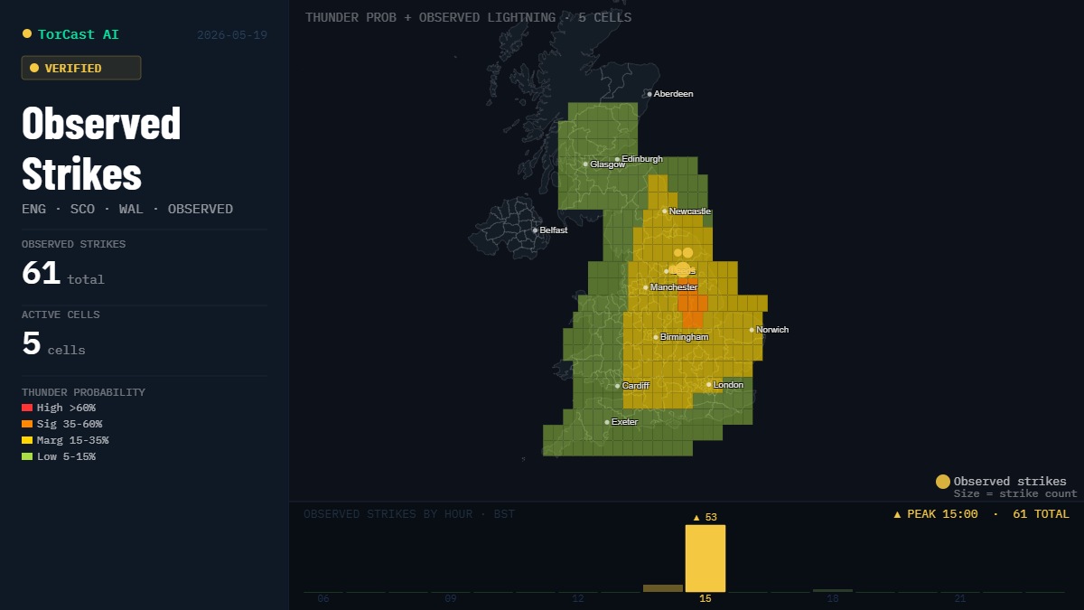
Want to help TorCast Ai learn and improve its forecasts? 
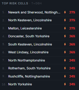
During convective events you can select a cell based on the region you live and then press Reports. 
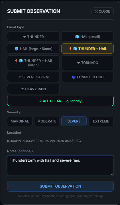
You can then report your findings which are then fed back into the model for verification and training.
TorCast Ai tweet mediaTorCast Ai tweet media
English
3
0
4
320
TorCast Ai
TorCast Ai@TorCastAi·
@BostonWeatherUK Looking highly likely there will be too much of CIN Cap for anything to happen.
English
2
0
0
29
Boston Weather
Boston Weather@BostonWeatherUK·
To summarise the hype over thunder this weekend: If the cap breaks it could go crazy. If it doesn't nothing will happen. It probably won't break.
English
2
0
4
81
TorCast Ai
TorCast Ai@TorCastAi·
@WeatherJamesUK Time for me to bring the air con unit out of its long winter hibernation 😂😂
English
0
0
2
36
JamesWeather
JamesWeather@WeatherJamesUK·
15z UKV continues to hold the trend of 34C as a max temperature on Sunday. However, as others have mentioned, the UKV can overestimate temperatures with a high lead time, so take this with a grain of salt. I believe hitting the 30C mark on Sunday is likely however.
JamesWeather tweet media
English
1
0
6
531
TorCast Ai retweetledi
Met4Cast - UK Weather
Met4Cast - UK Weather@Met4CastUK·
Hot summer? High pressure looks likely to be with us for the foreseeable with continued bouts of warm weather advecting north into the UK, temperatures again dependent on cloud cover, high pressure positioning etc but broadly speaking a dry and settled outlook. AAM looks to continue to sit in a positive state, especially with the recent MJO transition through phase 6 and into 7, these compositing to high pressure generally meandering over the UK, sometimes further west sometimes further east. i.e a very dry outlook for the foreseeable. As the phase 7 begins to filter through I wouldn't be too surprised to see signs of a cut off Iberian low developing sometime into early June, naturally this brings the prospect of further hot weather alongside thunderstorm activity. Essentially "steady as we are" for the next 1-2 weeks. Weather patterns look to continue remaining "stuck" or slow moving, I wouldn't be at all surprised if this were to become the broader pattern throughout summer. The likelihood of a warmer than average summer with some potentially hot or very hot bursts of heat into the UK is higher than normal.
Met4Cast - UK Weather tweet media
English
6
7
53
3.8K
JamesWeather
JamesWeather@WeatherJamesUK·
The @metoffice put out this graphic (the 10 day trend, would suggest you watch it on youtube), suggesting heatwave conditions are likely to be met, at least in the south.
JamesWeather tweet media
English
2
0
4
360
TorCast Ai
TorCast Ai@TorCastAi·
Some beefy showers have broken out across Aberdeenshire this afternoon. The odd lightning strike was seen around Fraserburgh a short while ago; a few more could be seen before the afternoon is out. Over the next week or so, it's going to be the heat rather than the storms. Friday afternoon, the UKV has some fairly decent CAPE but also a significant cap. The SE may catch a heavy shower or 2 overnight into Saturday
TorCast Ai tweet mediaTorCast Ai tweet media
English
0
0
10
285
TorCast Ai retweetledi
Nick's Weather Eye
Nick's Weather Eye@NickJF75·
Risk of isolated thunderstorms across SE England on Saturday as high WBPT plume (850 hPa theta-w temps of 18C) and elevated mixed layer (EML) spreads up from Iberia & W France with ECMWF showing a plume of CAPE / steep mid-level lapse rates spreading NE, though lack of trigger and rising heights make it a low risk.
GIF
Nick's Weather Eye tweet mediaNick's Weather Eye tweet media
Nick's Weather Eye@NickJF75

03z UKV showing 34C for a gridpoint in East Anglia on Sunday afternoon, 33C in London & Thames Valley. The record for May is 32.8C on 29th 1944, remarkable jump in temperatures for so early in year. Even if UKV is OTT with temps, likely to meet heatwave criteria, i.e. 3 days or more above certain temp thresholds, 27-28C across SE England / East Anglia

English
1
1
24
2.1K
TorCast Ai
TorCast Ai@TorCastAi·
Not the active storm day that was forecast but that's part of the game and the enjoyment. Plenty of lively showers did break out though with a few thunderstorms mixed in, if anything atleast they fired in or next to the highest risk areas the Ai model predicted. #ukweather
TorCast Ai tweet media
English
1
0
3
264
TorCast Ai
TorCast Ai@TorCastAi·
Some impressive heavy showers have broken out over the Preston/Bradford area in the last hour or so. No ⚡yet.
TorCast Ai tweet media
English
0
0
1
50
TorCast Ai
TorCast Ai@TorCastAi·
@WxMaccaUK All we can do now is sit and watch, and pray its not a bust 😂
English
1
0
1
31
TorCast Ai
TorCast Ai@TorCastAi·
Final Update: Tue 19 May ⚡ ⚠️Overall 🟦 MARGINAL risk across central/southern Britain, with a Significant (35%-60%) probability of thunder over Leicestershire / E Midlands. ⚙️ Profile: 400–800 J/kg CAPE, 24–28°C lapse rates, DLS 16–22 kt, weak cap. LI down to −4. ⛈️Risks: Hail, Heavy downpours, Gusty winds & an *Isolated funnel cloud possible along convergence boundaries cant be ruled out. *The Funnel risk from my Ai model is <2% but the signal has been consistent the last few days. #ukstorms #ukweather
TorCast Ai tweet mediaTorCast Ai tweet media
English
2
0
5
516
TorCast Ai
TorCast Ai@TorCastAi·
Here is the Tornado/Funnel Risk, this is HIGHLY experimental and should be taken with a pinch of salt. Would be interesting to know if any are spotted today
GIF
English
0
0
0
35
TorCast Ai
TorCast Ai@TorCastAi·
Greatest cells in the model at risk of Thunder at 15:00 BST
TorCast Ai tweet media
English
1
0
0
28
TorCast Ai
TorCast Ai@TorCastAi·
@luclee47 Yeah they have been hit or miss. Most of the ones recently have been focused in the Midlands/South or through the SW into Wales.
English
0
0
1
40
luclee
luclee@luclee47·
@TorCastAi Yeah, it’s just its a bit frustrating as i’ve not heard 1 rumble of thunder these past few weeks, not today, yesterday or last week wed/thu, bit annoying when u see met/bbc and stuff showing thunder and lightning. i guess thats just unlucky though as they’ve been hit or kiss.
English
1
0
1
27
TorCast Ai
TorCast Ai@TorCastAi·
Convective Outlook: Tue 19 May ⚡ UPDATE: The most recent run of my Ai model has expanded the MARGINAL risk area from this mornings run, expecting the Midlands and Yorksire to be the main focus where the LOW signal would be. ⚠️: Risk: 🟦MARGINAL / 🟨 LOW focus across the Midlands and central England, with isolated thunder possible across Wales, SW & SE England. ⚙️: Profile: 200–600 J/kg CAPE, 24–28°C lapse rates, DLS 16–30 kt, weak to no CIN Cap. ⛈️:Pulse-to-modest cells. Hail-led in any deeper updrafts. Peak 13-18 BST. #ukstorms #ukweather
TorCast Ai tweet media
English
3
0
2
105
TorCast Ai
TorCast Ai@TorCastAi·
@PremierRegulars Yeah - i will watch him or MaxVelocity if Reed isnt live. TornadoPageyy is another who I watch a fair bit.
English
0
0
1
12
TorCast Ai
TorCast Ai@TorCastAi·
@luclee47 I wouldn’t rule out the odd rumble of thunder/Heavy shower towards the end of the day, storms are likely to break out anywhere though. Main focus will be further north.
English
0
0
0
43
luclee
luclee@luclee47·
@TorCastAi So are you thinking parts of norfolk could see thunderstorms, just wondering as i live in norfolk and haven’t seen a storm in a while
English
2
0
1
19
TorCast Ai
TorCast Ai@TorCastAi·
@luclee47 It has some pretty heavy CIN cap logic in there to stop it basically issuing an extreme risk in a marginal setup. Comes down to a lack of inital training data for the ML Model to learn off. I have gathered enough so far this year to relax some of the logic.
English
1
0
0
20
luclee
luclee@luclee47·
@TorCastAi Ah okay, Why do you think it is under estimating? What are you expecting tomorrow?
English
1
0
0
11
TorCast Ai
TorCast Ai@TorCastAi·
@luclee47 The Western fringes of East Anglia are in the Marginal zone between 15:00 - 17:00 BST. The Thunderstorm risk map covers a much broader area than the Overall risk as that weighs up all the risk scores in the model. It is also likely under estimating tomorrow.
TorCast Ai tweet media
English
1
0
0
26
luclee
luclee@luclee47·
@TorCastAi Surprised East anglia isn’t in the marginal too
English
1
0
0
6