Don Murray

1.6K posts

Don Murray banner
Don Murray

Don Murray

@meteodon

Atlanta, GA Katılım Aralık 2015
241 Takip Edilen1.2K Takipçiler
Don Murray retweetledi
Sirens Project, Inc.
Sirens Project, Inc.@sirensproject·
We had the incredible opportunity of having ATL legend Glenn Burns as a guest on Episode 8 of our podcast! Great stories and insight from 42 years as chief meteorologist with WSB-TV. Check it out! youtu.be/-_J7YMMu2Kk?si…
YouTube video
YouTube
English
0
1
3
333
Don Murray
Don Murray@meteodon·
@sirensproject Looks like it starting to fill in on the western edge finally. Just take a short drive east, you do not have to go far ha
English
0
0
1
27
Sirens Project, Inc.
Sirens Project, Inc.@sirensproject·
@meteodon Maybe will get some moisture to fill in over the next hour so, but who knows 😂
English
1
0
0
34
Sirens Project, Inc.
Sirens Project, Inc.@sirensproject·
Ha. Yeah, no I didn’t want snow anyways…
Sirens Project, Inc. tweet media
English
1
0
3
204
Don Murray
Don Murray@meteodon·
@cyclonePORT network showing the substantial gradient in snowfall accumulations within a short distance inside the ATL metro area this am.. Canton GA has little to no accumulation while areas 30 miles east are picking up on heavier snowfall rates. #gawx
Don Murray tweet media
English
0
0
4
335
Don Murray retweetledi
Zach 🌪️
Zach 🌪️@tnstormhunters·
Here is some more information on what we are doing!
Vince Waelti 🌪@VinceWaelti

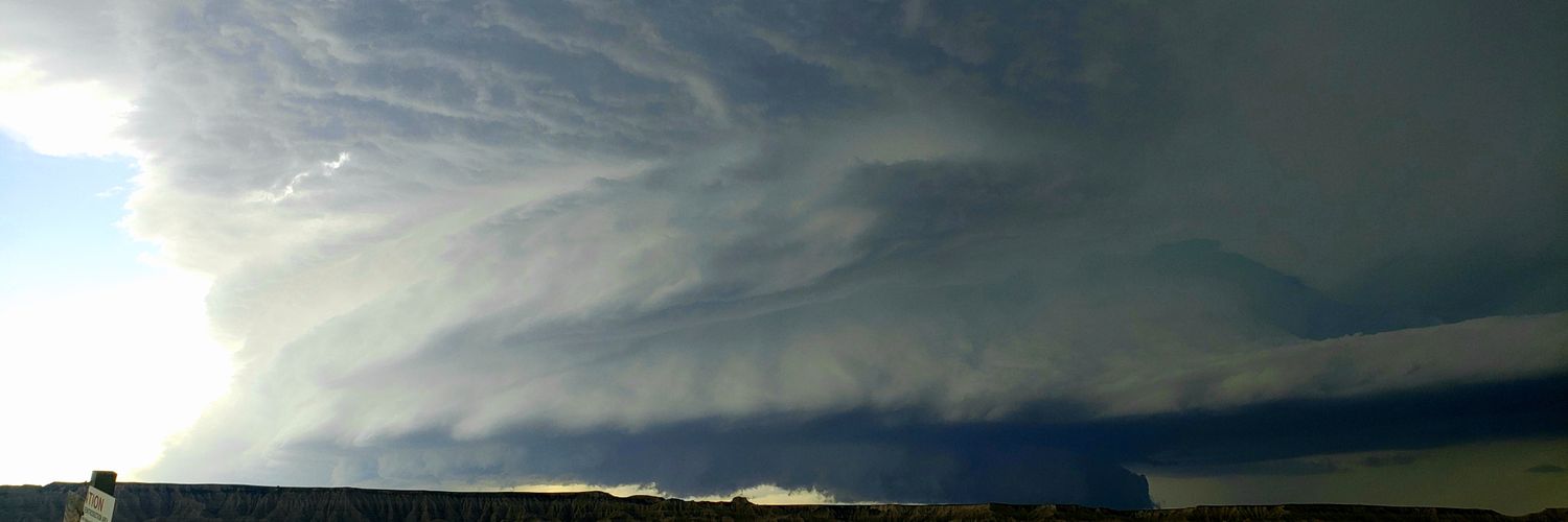
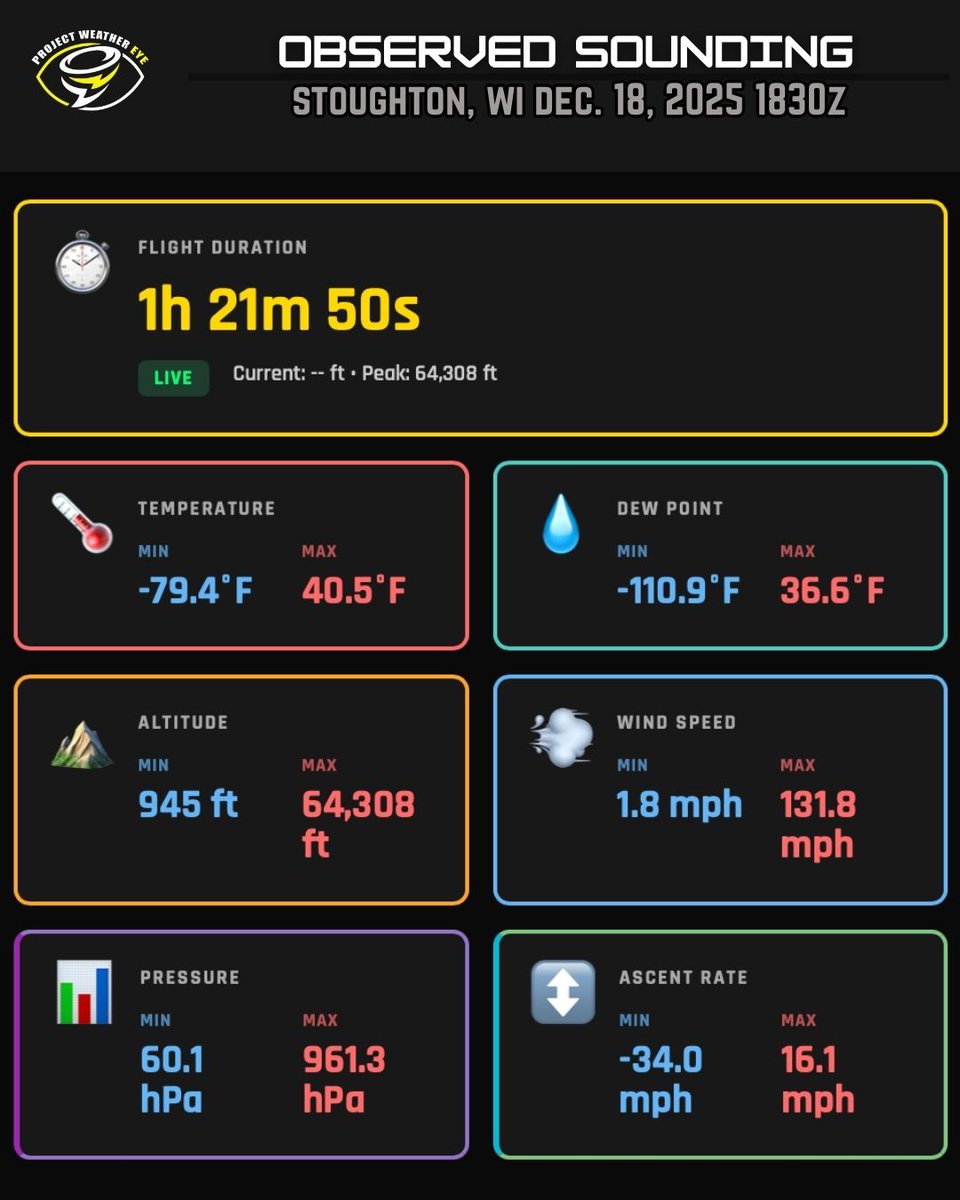
RISE-26, a crowd-funded severe weather research and forecasting mission takes off in a few months. We have a team of 9 field personnel now and are really excited to get this moving. Here’s a few things I keep getting asked: -I’m a college/University/student/other researcher, can I get the data? Yes. It’s live on our website AS IT HAPPENS and is exportable in SHARPpy or JSON. You can also get our full archive including probe data upon request. -How do you afford this? I don’t. We’re draining $6000 a month down our pants to some how pull this off. I nearly gave up diamond member parking! But our audience is helping offset this via GoFundMe on our website. You can help too: WxEye.org -I’m from Big Weather Company ABC I want to ingest your data for our proprietary model. No, you’d have to sponsor the project to do that. We provide data to non-profiting groups as a courtesy and to better science. This includes the NWS who can view our data live and requires no citation to use it. -How big is the balloon? Depends. Some are small, about 6 feet around while others are 12-15. It depends what we’re launching and how high we need to take our payload. -Do you call the FAA? I actually have a file with the FAA because so many folks have called in to report us. Our payload is under 4 pounds. I don’t need a NOTAM, but we do call the nearest air traffic control center and advise them of the launch as a courtesy. This is done by other staff, which is why you rarely see it on stream. We are not breaking any rules. -Did you build all this yourselves? Yes. I have spent the entire winter reinventing the wheel. We have a robust API like no other, an expanding network of ground receivers and the ability to push live data every second to your device. We’re literally connecting the balloon radiosonde to your phone with a virtual pipe. No one else does this on this level. I got paid nothing to do this. I am the one signing the checks and I didn’t pay myself. It just had to be done. -
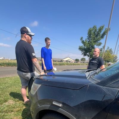
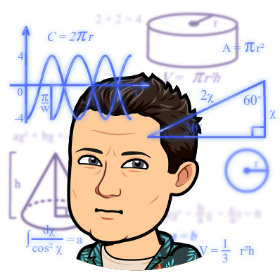
Do you need help? Yes and no. It’s best to email us with that. We do need skilled individuals. It’s very easy, even my 4 year old does it. See picture. -This needs to be a 90 minute documentary. Yep we have that being filmed by an independent too. You can follow all of our project -> @tnstormhunters @AidanO_wx @K707Wx @UpperAirGuy ScientificSales.com @RadarOmega @cyclonePORT

English
0
1
6
283
Don Murray retweetledi
Paige Berdomas🌪
Paige Berdomas🌪@tornadopaigeyy·
En route to go track this potentially HISTORIC winter storm. We are planning on streaming Saturday, Sunday, and Monday. Snow totals could be measured in multiple feet in areas that haven’t seen this magnitude of snow in years. There is going to be impacts further south with heavy amounts of mixed winter precip, with some areas seeing multiple inches of sleet. Beyond the sleet, a crippling ice storm could impact millions from Dallas Tx to northern Mississippi over through the western Carolinas and into the far southern mid Atlantic states. Ice accretions could exceed 1 inch in multiple areas. If you haven’t yet, you need to prepare NOW for impossible travel conditions, electrical outages for days (or weeks depending on amounts of ice). This means making sure that you have enough food, water, food for your animals, devices charged, medications, and a warm place to stay for an extended period of time. Get those blankets and flashlights ready! You can follow us live on YouTube or on the Radar Omega app, where you can download below for iOS and Android bit.ly/brycesheltoniOS bit.ly/brycesheltonan…
Paige Berdomas🌪 tweet media
English
12
9
82
5.1K
Don Murray retweetledi
Upper Cumberland Weather
Upper Cumberland Weather@CumberlandWx·
SURPRISE!!! The Upper Cumberland Weather app is now available for download for iPhones!!! Search ‘UC Weather’ on the App Store, or go here: apps.apple.com/us/app/uc-weat… We’ve now surpassed 1,000 downloads on Android devices and are trending at # 34 on the Google Play Store! Here’s where you can download for Android: play.google.com/store/apps/det… *note: we are aware of a glitch impacted a very small number of Android users that isn’t allowing access to the app - our developer is investigating the issue. Here’s our full app release announcement from the other day, in case you missed it: AT LAUNCH TODAY, here are a few key highlights of what our app is giving you: - SITE-SELECTABLE DOPPLER RADAR WITH DIFFERENT PRODUCTS AND ON-SCREEN WEATHER ALERTS **This may be an industry first for a LOCAL weather application. Most local weather apps only give you a national composite image that could be as much as 10-20 minutes old and becomes very 'blob-like' the further you zoom in. A handful of local apps will let you see base reflectivity from the nearest NWS radar site, but these are few and far between. Our app? We're giving you access to the ENTIRE network of NWS NEXRAD radar sites throughout the contiguous 48 states, including all four of the radar sites surrounding us (Old Hickory, Hopkinsville, Hytop and Morristown). And it's not just base reflectivity! We're offering more advanced products like velocity and rainfall estimates, among others! These products update in real-time as new scans are made by radar, ensuring what you are seeing is as up-to-the-second as possible. If you want to see a national composite image to get the 'full picture,' we offer that too! And our version of it is MUCH better than most other apps! **as for weather alerts, these are fully customizable to display whichever watch, warning and advisory products you want to see directly from the National Weather Service directly on the radar map. SPC Outlooks and mesoscale discussions can be toggled on/off, as well! - OUR SKYCAM NETWORK WITH LIVE VIDEO FEEDS **Our entire network of more than three dozen SkyCams here in the Upper Cumberland is available to you on demand! These are LIVE high definition video feeds capturing nearly every corner of the Upper Cumberland! You can also view the entire network of cyclonePORT camera sites throughout the country directly within our app, as well! Simply select the 'Weather Stations' toggle at the bottom of the screen. - CURRENT CONDITIONS AND FORECASTS **This wasn't yet ready when I originally showed off the app, but it is here at launch! Select up to 10 cities to view weather information for, including current conditions, seven day forecast and an HOURLY forecast. Here's the best part: these are NOT algorithmic products like most weather 'crap apps' give you. Current conditions are derived from the nearest airport as soon as new data is available (a future revision of the app will display live weather data directly from our SkyCam Network). Forecasts for both the seven-day and hourly products are derived straight from the National Weather Service. These are REAL forecast grids created by actual meteorologists serving our area, not a 'guesstimated' forecast that updates every five minutes based on whichever model just farted in the wind. - WEATHER STORIES **I'm super excited for this addition! This is my personal zone where I can post daily forecasts written by yours truly, complete with graphics and even video! We'll be further developing this section as we go along, but it's already pretty slick at launch with our first discussion post already made! - THE UPPER CUMBERLAND WEATHER CHANNEL **We're on YouTube, we're on HUB Plus (Roku), and now our channel is available directly within our smartphone app for viewing! For some of you, this may be the first time you've ever been exposed to our channel! Not only can you watch our channel 24/7 within the app, but you'll be able to watch our severe weather coverage here, as well! I want to give a HUGE shout out to our partner, SDS Weather, for developing this app. I especially want to thank @meteodon for the hard work and countless hours that have gone into creating this app quite literally from scratch. The launch of our app today is the dawning of a new era. We're setting out to redefine what a local weather app SHOULD be, and what we've released today is only the beginning... MANY MORE FEATURES are planned for the near and extended future! Push notifications are already in the works -- I'll be able to send a notification directly to your phone anytime I'm going live with severe weather coverage...or if there is any other important information I need to share with you. This feature will be included in one of our first updates very soon, among others that will come down the line! I greatly appreciate the patience of each and every one of you as we've worked to get the app out to you. Our great communities deserve the very best when it comes to hyperlocal, real-time weather information you can trust, and I'll never stop working toward improving upon that mission.
Upper Cumberland Weather tweet media
English
0
4
17
715
Don Murray retweetledi
Project WeatherEye
Project WeatherEye@stsweathereye·
Min/Max stats of our weather balloon sounding today at 1830z. Summary: It's cold and very windy up there at 65,000 feet. Check out the max wind speed of 132mph!
Project WeatherEye tweet media
English
0
3
27
1.3K
Don Murray retweetledi
Connor Croff
Connor Croff@ChasingWConnor·
Birds Eye view of the Levee breach being repaired near Kent, WA! We’re live now! @MaxVelocityWX @RadarOmega
Connor Croff tweet media
English
2
11
133
12.9K
Don Murray retweetledi
Upper Cumberland Weather
Upper Cumberland Weather@CumberlandWx·
Entries for our 9th Annual Christmas Giveaway are now OPEN!!! This is Facebook only, open to those who live in the Upper Cumberland region of Middle/East Tennessee. Head over to our Facebook page to enter!
Upper Cumberland Weather tweet media
English
0
2
5
606
Don Murray retweetledi
Vince Waelti 🌪
Vince Waelti 🌪@VinceWaelti·
PWE has been hard at work. The entire team from me to our developers, hardware engineers and chasers. That includes our partners, supporters, and even the audience for keeping up with it all. We have the intent to blend weather data collection, research, and live content thru a collaborative effort between our staff, partners, and viewers. These crowd-funded science missions are highly funded by the audience. We’re running a fundraiser to reinforce the budget a bit and ensure we don’t have to skimp in 2026. We’ve reached 20% of our goal in 3 weeks! gofund.me/8d0a66fc8
Project WeatherEye@stsweathereye

🌧️ FIRST TEST MISSION SUCCESSFUL: The data vs the storm…. ⚡️ SUPERCELL ⚡️ A late season storm formed in far southeast Missouri yesterday afternoon. This thing would have been amazing if there was another hour of daylight! 🎈 I also sent up a sonde to sample the environment. Here’s the storm versus the thermodynamic properties that formed it. Little inversion there probably didn’t help it, but check out how dry it is about 800mb or so. 🚫Scientists: that is -not- our new Skew-t / Log-p viewer. That viewer is -almost- done. This is just a simple html plot from the API data and is very crude. ⬆️ 72,000 feet temperature = -94°F 🌡️ 👀 View the “user friendly” data plots: tinyurl.com/3wj4848n

English
0
2
27
3.5K
Don Murray retweetledi
Aaron Jayjack
Aaron Jayjack@aaronjayjack·
Northern lights going bonkers!!! Best red aurora I’ve seen with the whites of my eyes!! Wow
Aaron Jayjack tweet media
English
33
207
2.1K
90.8K
Don Murray retweetledi
Upper Cumberland Weather
Upper Cumberland Weather@CumberlandWx·
1:40 p.m. CST - Snow showers are beginning to pick up this afternoon as a big impulse dips southeastward out of Kentucky. A Winter Weather Advisory is in effect for Clay, Cumberland, Fentress, Jackson, Overton, Pickett, Putnam, Van Buren and White Counties until 6 p.m. -- the higher elevations of these areas could pick up as much as an inch of snowfall this afternoon, making travel difficult. Those in lower elevations could see anywhere from a dustin to a half inch. I wouldn't be surprised if we also see a light coating in a few other areas where heavy bursts of snow showers put down quite a bit of accumulation. Snow showers will begin to taper off this evening to just a few scattered flurries. Let me know what you're seeing in your area!
Upper Cumberland Weather tweet mediaUpper Cumberland Weather tweet mediaUpper Cumberland Weather tweet mediaUpper Cumberland Weather tweet media
English
1
2
10
788
Don Murray retweetledi
Connor Croff
Connor Croff@ChasingWConnor·
There is a good chance this band of snow tonight into tomorrow will be some of the heaviest snowfall to ever occur in the Chicagoland area. Snowfall rates of 3-6 inches per hour, frequent thundersnow, and even hail will occur in this band. While the snowband may only stay over one area for a few hours, due to the intensity of the snowfall rates, it will only take a few hours to rack up 8+ inches of snow. If the band stalls over any one area for more than a few hours the snowfall will be measured in multiple feet. The NWS highlights the concern for stalled and stranded traffic early monday morning inside the band. I will be live on YouTube (Connor Croff) and in the Radar Omega app beginning in just a few hours with all night coverage tonight. @MaxVelocityWX @RadarOmega
Connor Croff tweet media
English
22
133
1.9K
405.6K
Don Murray retweetledi
Jesse Ferrell
Jesse Ferrell@WeatherMatrix·
As Hurricane #Erin gets slightly better coverage on the San Juan Puerto Rico radar, the eye starts to become "stronger." (This map is upside down looking south towards the Virgin Islands)
English
1
2
12
1.8K
Hunter Hurley
Hunter Hurley@hunterhurleywx·
Hey all! I've been Co-Developing this project with @TwisterKidMedia for about a month now, and we've made some changes to how the interface works, and also included a 'How to Report' section. We also have a web-domain now! -- reportbuddy.org -- Best accessible on Google Chrome and Fire Fox on mobile devices, you can also bookmark it onto your home screen for easy access. We will be working on compatibility with Safari soon, and eventually create an app download for smoother use. We would love to receive feedback on what we can improve on, and what we can change to better help spotters send accurate reports!
TwisterKidmedia@TwoDogsWx

By now some folks have probably seen early versions of Report Buddy floating around. Holden snagged the first tornado pic with it. Ill be open sourcing the code that started as a personal replacement/enhancment for spotter network and mping. adlyons.github.io/report_buddy.h…

English
16
21
83
18K
Don Murray retweetledi
Connor Croff
Connor Croff@ChasingWConnor·
Gonna save the rest of my footage for the YT video that won’t be out for 8 months but just gonna leave this clip here because I can not believe a tornado can move like this…
English
678
3.8K
31.1K
1.9M