Francis Rengers

1.6K posts

Francis Rengers banner
Francis Rengers

Francis Rengers

@pyrogeomorph

Researcher of post-fire debris flows and landslides. Trying to make pyrogeomorphology “a thing”.

Colorado, USA Katılım Şubat 2008
856 Takip Edilen693 Takipçiler
Francis Rengers retweetledi
Boulder Office of Disaster Management
The National Weather Service has issued a Flash Flood Warning on 8/7/24 until 6:30 p.m. for the Stone Canyon Fire burn scar area. Law enforcement in the area is not seeing significant impacts at this time. We have not issued a Climb to Higher Ground order, however, please pay attention to your surroundings and take action if necessary. 
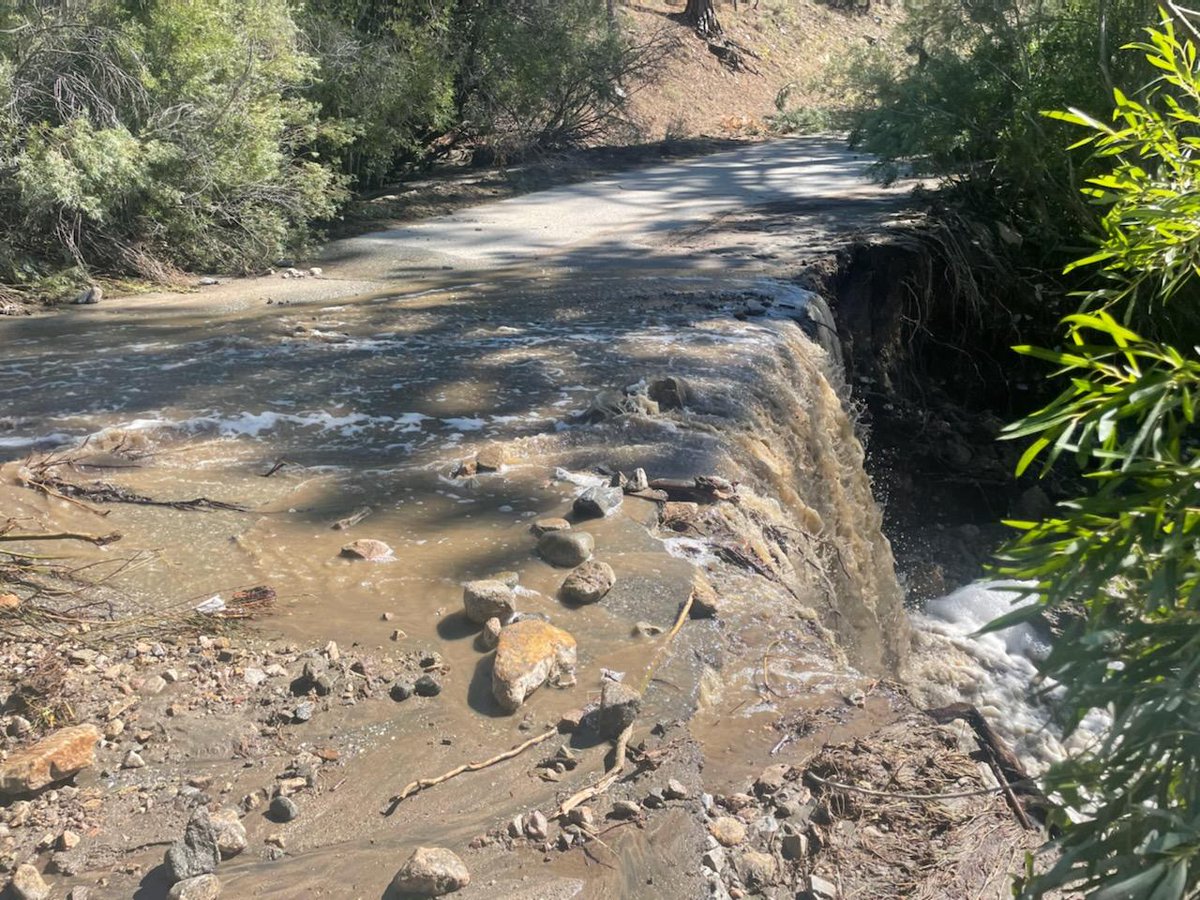
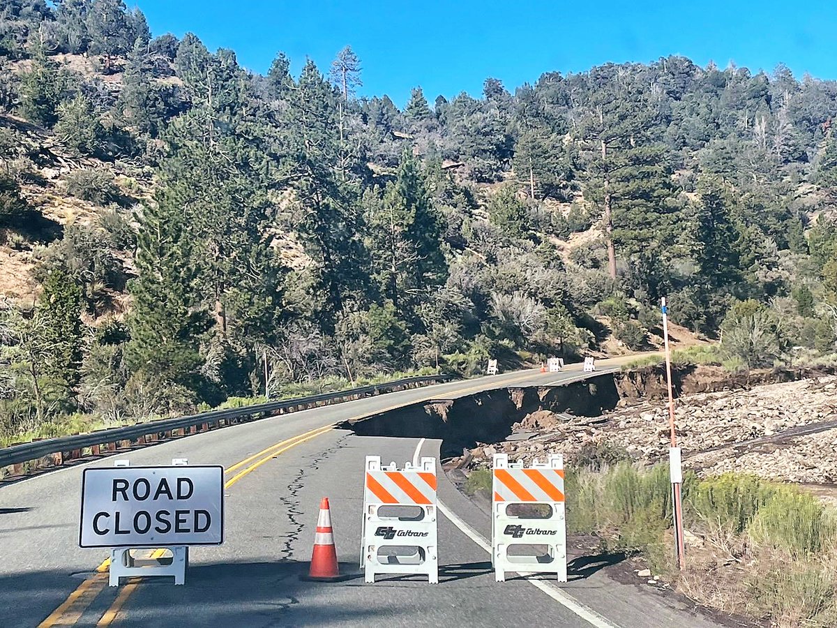
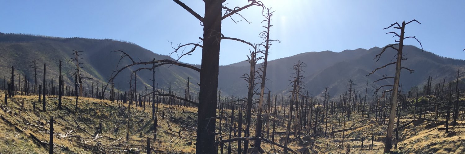
Radar indicated thunderstorms producing heavy rain over the Stone Canyon Burn Scar.  The expected rainfall rate is .25 inches in 15 minutes.  Flash flooding is ongoing or expected to begin shortly.  Excessive rainfall over the warning area will cause debris flows near steep terrain.  The debris flow can consist of rock, mud, vegetation, and other loose materials. Impact includes life threatening flash flooding of areas in around the Stone Canyon Burn Scar. Locations that may experience flash flooding include Stone Canyon Road and Stone Canyon HOA. Heavy rainfall will cause flash flooding of creeks, streams, and ditches in the Stone Canyon Burn Scar. Debris flows can also be anticipated across roads.  If you encounter flood waters climb to safety.
Boulder Office of Disaster Management tweet media
English
0
10
11
7.5K
Francis Rengers retweetledi
NWS Albuquerque
NWS Albuquerque@NWSAlbuquerque·
Here's a look at the hydrograph for the Rio Ruidoso. The water will continue to race downstream toward Glencoe this afternoon. Stay safe! #nmwx
NWS Albuquerque tweet media
English
0
8
17
2K
Francis Rengers retweetledi
NWS Albuquerque
NWS Albuquerque@NWSAlbuquerque·
The Rio Ruidoso at Hollywood jumped into MAJOR flood stage - over 15 feet! Look at the last few frames of this video. Stay away from the river banks! It could be deadly! #nmwx
English
4
33
127
11.1K
Francis Rengers retweetledi
Chad Casey
Chad Casey@WxFanaticCC·
Hail flow happening west of Scottsbluff, NE #newx
English
164
600
3.3K
693.8K
Francis Rengers retweetledi
Billy Bowling  𝕏
Billy Bowling  𝕏@babowling12·
A timelapse of the wildfire in @NewRiverNPS from the iconic Grandview Overlook tonight. 📍Grandview, WV
English
11
103
309
84.1K
Francis Rengers retweetledi
Dr Robbi Bishop-Taylor 🦋
Dr Robbi Bishop-Taylor 🦋@SatelliteSci·
The scale of the fires currently burning across northern Australia is pretty unfathomable. This animation visualises just the last two months of fire captured by #DEAHotspots - for context, the map covers an area larger than France, Spain and Germany combined...
English
180
2.6K
5.7K
908.9K
Stephanie Kampf
Stephanie Kampf@kampf_stephanie·
The sad fate of a rain gauge. Why would anyone do this??
Stephanie Kampf tweet media
English
3
1
10
2.2K
Francis Rengers retweetledi
Colin McCarthy
Colin McCarthy@US_Stormwatch·
Satellite image of California shows virtually no smoke across the state in typical peak fire season, with fire activity confined to the extreme northwest part of the state. Only 257,000 acres have burned across the state this year, which is 4.5x fewer acres than the 5-year average of 1.15 million. California has experienced yet another quiet fire season so far, compared to recent years (2020 and 2021). This past year's very wet winter, combined with very few significant heatwaves and fire weather events, has resulted in minimal fire activity outside far Northern California and the Mojave Desert. Soil moisture across much of the state remains well above normal due to several significant moisture intrusions (e.g. Hilary) and a robust marine layer.
Colin McCarthy tweet media
English
138
419
3.5K
605.6K
Francis Rengers retweetledi
San Bernardino National Forest
San Bernardino National Forest@SanBernardinoNF·
Personnel of the San Bernardino National Forest are conducting surveys and assessments of damage to sites and areas on the forest due to Tropical Storm Hilary’s landfall, Aug. 20-21. Read our safety messages and information about the impact of the storm at fs.usda.gov/detail/sbnf/?c…
San Bernardino National Forest tweet mediaSan Bernardino National Forest tweet mediaSan Bernardino National Forest tweet mediaSan Bernardino National Forest tweet media
English
1
13
23
5.3K
Francis Rengers
Francis Rengers@pyrogeomorph·
Hi everyone! There is a new opportunity to study postfire debris flows as part of the USGS Landslide Hazards Program in Golden, Colorado! Application deadline is November 1st. usgs.gov/centers/menden…
Francis Rengers tweet media
English
1
21
60
7.3K
Francis Rengers retweetledi
Melaine Le Roy
Melaine Le Roy@subfossilguy·
#Fluchthorn rock avalanche (2023-06-11) volume estimate yielded 1 Mio m³ - that makes it one of the biggest high-alpine rockfalls, and one of the few known to have decapitated a summit! 🏔️ Fascinating video about laserscan survey of the site! Source @jan_beutel @uniinnsbruck 1/
English
3
44
138
13.9K
Francis Rengers retweetledi
NWS Pueblo
NWS Pueblo@NWSPueblo·
The damage survey along Pikes Peak is complete and the survey team found damage consistent with an EF-1 tornado with estimated winds up to 108 mph. Check out the graphic for more info and an estimation of the tornadoes path. #cowx
NWS Pueblo tweet media
English
3
89
306
52K