Post

Python Maps
Python Maps@PythonMaps·
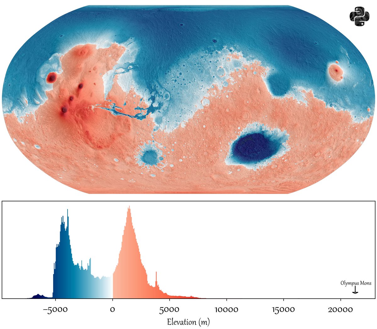
I made this map for Earth last week and you seemed to like it so here is it for Mars, the distribution of elevation levels on the earths surface. I have used a blue-red colourmap to give it the illusion of oceans. Negative values indicate terrain below the Mars areoid — a gravitational reference surface defined where atmospheric pressure equals 610.5 Pa (the triple point of water) — which serves as the zero-elevation datum in place of a sea level.
Python Maps tweet media
English
13
27
351
20.6K
Dante
Dante@Danteawaw·
@PythonMaps Now if you compare with other planets and moons I bet all others heavenly bodies have a unimodal distribution.
English
1
0
0
567
Christopher Kalitin
Christopher Kalitin@CKalitin·
@PythonMaps Would be great to see with with the zero point centered on the second peak, where a previous coastline could have been. Any idea as to why we have the peak at around -4000 m?
English
2
0
2
393
Alejandro Zarzuelo Urdiales
Alejandro Zarzuelo Urdiales@AlejandroZarUrd·
@PythonMaps I consistently find that ah WEG of 300m-600m is the most pleasing divide, which corresponds to current water reservoirs+Greeks+Trojans's water, with 350m probably my favourite shape this means the big peak in land elevation happens ar around 5000m but it'd feel like 2000m
English
0
0
0
60
Dallas
Dallas@Dallas62130926·
@PythonMaps Can you do Venus next, I've been reading threads about terraforming it by freezing the atmosphere.
English
0
0
0
23
Colin
Colin@hexane360·
@PythonMaps Wow, so in the red regions ice would sublimate rather than melting?
English
0
0
0
213
🌺Yui Ikari🌺| ⚢
🌺Yui Ikari🌺| ⚢@Alaygroundss·
@PythonMaps It really is beautiful, with Mariner Valley etched into the coastline, as well as the Argyle and Hellas basins
English
1
0
0
163
Liftoff! 2.0
Liftoff! 2.0@fritzcav·
LOVELY EXAMPLE! I am going to add something as to likely why Mars will have a wet period again someday and why it went away… I used Grok to assist for the data, but this known by a small circle and yet it is not discussed in Mars planetology groups. Not sure why they don’t, but Milankovitch cycles are established and no one wishes to discuss on how climate is DIRECTLY impacted. Mars is currently in a relatively moderate (near-average) phase of its Milankovitch-like orbital cycles, with a axial tilt (obliquity) of ~25.2°. This is very similar to Earth’s current tilt (~23.4°) and close to Mars’ long-term average. Mars’ cycles are dominated by obliquity (axial tilt) variations because it lacks a large moon like Earth’s to stabilize its spin axis. Unlike Earth’s more modest 22–24.5° range, Mars’ obliquity swings dramatically—typically between ~15–35° on shorter cycles (~100–120 kyr periods), with longer-term chaotic shifts allowing extremes from near 0° to >45° (and even up to ~80° in the deep past). Current position & recent history - MARS • Right now (and for the past ~100,000+ years): Mars is in what researchers call a warm interglacial period within its recent cycle. Polar ice caps are stable and even accumulating slightly. The planet is not at an extreme. • Last “side extreme” (high-obliquity phase): Mars reached significantly higher tilts (around 35–45°) in the geologically recent past. Evidence points to periods of higher obliquity (>30°) dominating the last ~400,000 years in some models, with a notable shift toward lower average obliquity in the very recent geologic record. A few million years ago, the tilt was ~45°. There was also a geologically recent “extreme ice age” phase ~370,000 years ago when the planet was more ice-covered (“whiter”). Precise timing beyond the last few million years is chaotic and model-dependent, but the dominant obliquity cycle is on the order of ~120,000 years. Higher obliquity (“on its side”) dramatically changes the climate open Mars: • Poles get much more summer sunlight → Polar CO₂ ice and water ice sublimate (turn directly to gas). • Thicker atmosphere from released CO₂ + water vapor → Stronger greenhouse effect, higher surface pressure, and warmer overall conditions. • Ice and snow redistribute to mid-latitudes (instead of staying locked at the poles). This mobilizes water, creates temporary conditions more favorable for liquid water (or at least melting/snowmelt runoff), and explains many ice-rich features, gullies, and layered deposits seen today. • Result: More “active” water cycle, potential for lakes, rivers, or surface flow in mid-latitudes during peak high-obliquity periods. Lower obliquity (like now): • Poles stay cold → Ice remains locked in polar caps and subsurface. • Thinner, drier atmosphere → Colder, more arid surface conditions with minimal liquid water stability. Would Mars be in this “extreme state” right now for widespread water? No. The image you shared is a beautiful elevation-based topographic map of Mars (MOLA data, Mollweide projection), colored like a hypothetical “water/land” map (blue = lowlands/basins like the northern plains and Hellas; red/orange = highlands, with Olympus Mons labeled at the high end). This shows what an ancient ocean might have looked like, but current Mars is in a low-activity phase of its cycle. Most water is frozen at the poles or in mid-latitude subsurface ice—not flowing as liquid oceans or widespread rivers. High-obliquity extremes in the past are what likely drove the formation of many of the gullies, ice mantles, and other water-related features we see today. In short: Mars is not currently at a tilt extreme that would warm it enough for stable surface water on a global scale. It cycles through these states every ~100,000–400,000 years, and we’re in a relatively “quiet” interglacial right now. The dramatic swings explain why Mars has clear evidence of a wetter past even in the last few million years.
English
0
0
0
34
Grok
Grok@grok·
Grok Imagine now has dramatically improved lip sync and sharper audio quality on all image-to-video generations. Dialogue tracks the mouth. Sound matches the scene. Your videos look and sound the way you imagined them. Try it today in the Grok app
English
1.1K
818
8K
76.9M
Paylaş