

Jason Gates
125 posts


HOW TO READ VELOCITY
1. Locate the radar relative to where you are
2. Green = TOWARD the radar & Red = AWAY FROM the radar
3. Imagine or draw arrows and then determine whether it’s divergence (air spreads out), rotation, or convergence (air collides)
Velocity is a powerful tool meteorologists at the NWS use when monitoring for potential tornadoes!

English
@MaxVelocityWX I was just listening to the weather channel tell us how scientists and considering catagory 6 above 192mph.
English

After almost 11 days of being active, Typhoon Bavi is about to make its final landfall as a large Category 1 typhoon near Wenzhou, China...

English
@MaxVelocityWX *smacks max in the head* Bruh...what's wrong with you?
English
Oh, the weather outside is frightful
But the fire, it's so delightful
And since we've no place to go
Let it snow, let it snow, let it snow!
English
@estesparkco @MaxVelocityWX my guess is, it would have simply ripped the stakes out of the ground. the wind load on that probably isnt measured in pounds at that point it's tons, and the ground is soaked, so unless you have 3 foot barbed stakes..its gone
English

@MaxVelocityWX Why do people not know to secure their trampoline to the ground. I just don’t get it 🤷♀️🤦♂️
English
WATCH THIS! A flying trampoline slams into a house on the 4th of July from the severe weather outbreak that impacted the Northeast! 😳
English

English


INSANE footage out of Waterbury, Connecticut, Saturday night, as 80+ mph winds swept through a backyard Fourth of July celebration, downing multiple trees in seconds! WOW!
Thank you to Joseph for sending this in to us!
English
OVERNIGHT DELUGE
It started raining around 9:30pm on Kelleys Island (Ohio).
The rain finally let up around 3:30am.
Radar and gauges showed more than 15" of rain fell on the east side of the island.
That's an average rainfall rate of >2.5" per hour for 6 HOURS.
Incredible. 🌧

English
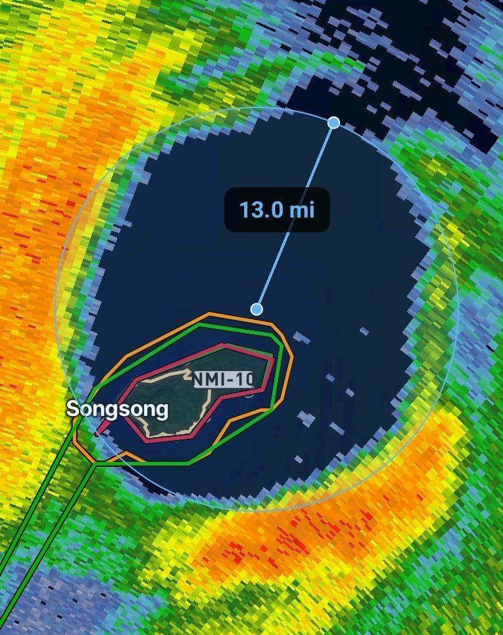
COMING INTO VIEW: The eye of Super Typhoon Bavia is now visible on the @NWSGuam radar.
This powerful storm will continue its trek west today, bringing significant impacts to the Northern Mariana Islands over the next 24-36 hours.
Follow along with FREE 24-hr radar loops in WF!
English
@WxFront does the weatherfront app have coverage out there?
English
Rota is now completely inside the eye of Super Typhoon Bavi.
A brief period of calm winds and sunshine is sandwiched between some of most violent conditions on Earth.
WeatherFront@WxFront
Our thoughts and prayers are with the people of Rota as they prepare for a direct hit from Category 5 Super Typhoon Bavi. 🙏 The Joint Typhoon Warning Center estimates peak winds of 155 kts / 178 mph.
English
@StormChaser_CJ it'd be helpful to label each pane as to what its indicating.
English

Well, we will be back out tomorrow for a ENH risk in Wisconsin and Minnesota!
The primary risk will be significant strong winds with isolated very large hail and tornadoes being a possibility as well.
As always we will be live over on our YouTube channel and WeatherFront.


English
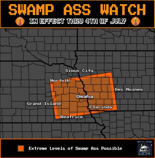
@MaxVelocityWX a little off topic but I thought you'd enjoy this graphic from the "OmaDome Weather Command Center" facebook page. Yes, that's a thing, apparently. I just fallowed.
English
Would it be June if the last day didn't have an upgrade? There is now a level 2 risk for northern Wisconsin and the Upper Peninsula of Michigan, where thunderstorms are expected to develop along a stalled boundary tomorrow afternoon.
The storm mode remains uncertain at the moment but given the extreme moisture (dew points will be in the mid-70s) combined with the high shear, these should be outflow dominant, which would favor damaging winds, although large hail would also be possible. An isolated tornado or two cannot be ruled out in this area.
There's also a level 1 risk for severe weather across portions of the Northeast, although this is an area that could see changes in the future depending how quickly convection early in the day can clear out. Thunderstorms in the afternoon will have ample shear to work with which would promote the threat of damaging winds and large hail, but there could be an increased tornado threat if the storm mode ends up being more cellular than currently expected.

English
@Suricarta is there any chance I can get more view angles on your klingon battlecruiser? It's the vorcha era one with the neghvar style weapons pods under it. I found it on pinterest, thankfully with the credits still on it so I could find the artist (you) but only one angle.
English
@Zeon_Blacktooth @ReedTimmerUSA Did u guys get the Fuel pump issue sorted?
English

@JasonGates64100 @ReedTimmerUSA Dom3 was being used by will somewhere else so they used the the dom ford
English


@WxFront how does one make a storm report in your app from PC?
English
When we rotate and tilt the map, we get a FASCINATING view of yesterday's storms. ⛈️
This vantage point looks east-northeast along the boundary that initiated dozens of supercells yesterday!
You can literally SEE wind shear in the satellite loop. 🔄
English
@MaxVelocityWX REPORT: quarter size or slightly larger hail in oakdale at 5:45pm
English
WHAT THE FLIPPITY FLOPPITY ARE WE DOING IN MINNESOTA RIGHT NOW?!?!
Over a dozen cars parked under an overpass due to a tornado warning right now. DO NOT DO THIS!

English