School Closings & Weather MI ❄️

23 posts

School Closings & Weather MI ❄️ banner
School Closings & Weather MI ❄️

School Closings & Weather MI ❄️

@SchoolClosingMI

School Closings & Weather Alerts – Michigan ❄️⚡️ Stay updated, stay safe! Always verify with your local school/district.

United States Katılım Ocak 2014
1.2K Takip Edilen10.7K Takipçiler
School Closings & Weather MI ❄️
School Closings & Weather MI ❄️@SchoolClosingMI·
❄️ School Closings/Delays for 10 Nov 2025 Akron-Fairgrove Schools Closed Monday Birch Run Schools Closed Monday Caro Schools Delayed Monday 2 Hours Carrollton Schools Closed Monday Reese Public Schools Closed Monday Unionville-Sebewaing Schools Delayed Monday 3 Hours
English
1
2
4
906
Drew Brummel
Drew Brummel@WMstormchaserDB·
Absolutely terrible road conditions throughout Northern Indiana and SW Michigan! Conditions will only worsen especially in NW Indiana and the Chicagoland area as temperatures continue to drop and as snowfall rates increase!
Drew Brummel tweet media
English
1
4
23
1.3K
Aaron Rigsby
Aaron Rigsby@AaronRigsbyOSC·
Brutal driving conditions on the Indiana turnpike near South Bend #INwx
English
25
130
1.2K
53.6K
Reed Timmer, PhD
Reed Timmer, PhD@ReedTimmerUSA·
LIVE EMERGENCY UPDATE on the lake effect snow machine going full throttle off Lake Michigan! Looks like this lake effect snow plume is pivoting and heading straight for Chicago tonight!
English
20
85
771
86.2K
WindyCity Weather and News
WindyCity Weather and News@WindyCityWxMan·
Definitely a solid band of lake effect #snow (LES) setting up down the length of Lake Michigan Meso low already ashore into SW lower MI with tailing band of LES for north IN Question still without a clear answer: how far west will it swing. Watching Green Bay to Milwaukee area
English
3
9
54
12K
Michigan Storm Chasers
Michigan Storm Chasers@MiStormChasers·
We have found our overachiever of the lake effect event… so far! ❄️ Here at 8 pm EST Sunday evening the 9th, a couple locations just to the south of Peshawbestown have recorded nearly a foot of snow, with the top location right on the Grand Traverse Bay reporting 11” of snow since snowfall began yesterday. This lake effect band has been super impactful across Leelanau county as a whole and points surrounding, with multiple accidents and power outages filtering in. The north wind tonight will continue to funnel in more snow towards Traverse City and Kingsley with time. For those in northwest lower Michigan, we’d love to see your snow photos. Send them in the chat below, and let us know where you are reporting from, and whether or not we may post with permission.
Michigan Storm Chasers tweet media
English
2
5
81
5.4K
Connor Croff
Connor Croff@ChasingWConnor·
Whiteout conditions south of Three Oaks, MI. Blowing and drifting becoming a big problem. @RadarOmega
English
9
45
455
18K
Bob Waszak
Bob Waszak@nilwxreports·
5pm Lake Effect Snowstorm Update: Summary: - Very heavy snow is expected tonight through Monday morning across northeast Illinois along the lake including Chicago. Light snow showers are occuring now but a organized lake effect band will begin to take shape after 8-9pm with periods of very heavy snow after 10pm through daybreak on Monday with heavy snow tapering to snow showers across northeast Illinois mid morning into midday tomorrow. Accumulating snow will be done by tomorrow afternoon for Chicago with heavy lake effect snow continuing across northern Indiana through tomorrow evening. Travel Impacts: - We expect significant travel impacts overnight and during tomorrow mornings commute across northeast Illinois in areas near the lake. Not far from the lake, snow showers may be occuring but any accumulations should be light. Travel conditions will improve drastically tomorrow afternoon as heavy snow moves east. Northern Indiana will expect impactful travel conditions from tomorrow morning through tomorrow evening. Total Snow Accumulations: - For northeast Illinois including Chicago and lake shore communities, 6-12 inches will be expected with localized 12-15 inches possible under the heaviest bands. Away from the lake, snowfall amounts will dimish quickly especially west. The southern end of the lake could see heavier totals as well all depending where the snow band sets up. Northern Indiana, 6-12+ inches as well will be expected with localized 12-18 inches possible. Snowfall rates will be as high as 2-4 inches per hour at times overnight and tomorrow morning which will allow for rapid accommodations on all surfaces including roads and sidewalks. We will post updates as the night goes on, slight shifts in the snow band will lead to big differences in snowfall totals and impacts so be prepared and hopefully it won't be too bad. #ilwx #inwx
Bob Waszak tweet media
English
5
13
210
36.5K
Max Velocity
Max Velocity@MaxVelocityWX·
Intense snowfall is making travel dangerous to impossible around southern Lake Michigan as we are now seeing snowfall rates in excess of 3" PER HOUR! You can follow along with the snow LIVE with TornadoPaigeyy and Bryce Shelton on the RadarOmega app!
English
37
258
2K
127.6K
NWS Detroit
NWS Detroit@NWSDetroit·
Lake effect snowfall will continue across the area this afternoon and evening, with the heaviest snow focused across the Tri-Cities region and the eastern Thumb into northern Metro Detroit. #miwx
NWS Detroit tweet media
English
1
8
17
2.8K
NWS Detroit
NWS Detroit@NWSDetroit·
Lake effect snowfall will continue across parts of Southeast MI this evening, with the steadiest snow focused near/east of Saginaw and across the eastern Thumb into Port Huron. Snow covered and slick roads and reduced visibility remain hazards into tonight. #miwx
NWS Detroit tweet media
English
1
9
23
3.4K
NWS Chicago
NWS Chicago@NWSChicago·
How much snow are we talking? Much like a summer thunderstorm, lake effect snow is very localized leading to widely varying totals. This map represents a possible outcome, though some areas may pick up much more and much less. Note the sharp gradient near I-355 and I-55. (4/5)
NWS Chicago tweet media
English
3
27
138
204K
NWS Chicago
NWS Chicago@NWSChicago·
Let's talk about the upcoming lake effect snow. The snow will start between 9PM and 12 AM tonight near Lake Michigan and spread inland. Bands of snow will then park near the IL shoreline Monday morning, and migrate eastward into Indiana Monday afternoon. #ILwx #INwx (1/5)
NWS Chicago tweet media
English
9
81
337
121.2K
NWS Grand Rapids
NWS Grand Rapids@NWSGrandRapids·
Monday Afternoon to Evening: • Bursts of moderate-heavy lake effect snow near and west of US-131. • Areas of slick roads and rapid changes in visibility. (2/2)
NWS Grand Rapids tweet media
English
1
0
9
1.7K
NWS Grand Rapids
NWS Grand Rapids@NWSGrandRapids·
Sunday Afternoon to Monday Morning: • Areas of slushy or icy pavement developing. • Some locations receive bursts of moderate-heavy lake effect snow this evening. • Overnight temperatures falling into 20s. • A lull in the falling snow during the morning commute. (1/2)
NWS Grand Rapids tweet media
English
1
2
25
3.3K
NWS Grand Rapids
NWS Grand Rapids@NWSGrandRapids·
Rain to snow tonight through early Sunday. There remains some question on amounts due to the rain and the temps. However, there is a chance for 2 or more inches of snow along I 94 and in Mason and Oceana counties. Lake effect snow possible Sunday night into Monday west of US 131
NWS Grand Rapids tweet media
English
2
6
33
5.3K
Michigan Storm Chasers
Michigan Storm Chasers@MiStormChasers·
HEAVY snow has begun in Niles, MI! Snowfall rates of 1-2" per hour are ongoing within lake effect banding. Camera is sponsored by Jessica Massey - State Farm Agent
English
5
23
177
4.2K
Michigan Storm Chasers
Michigan Storm Chasers@MiStormChasers·
It is RIPPING currently in LaPorte, IN and surrounding areas! Snowfall rates will exceed 1-2” per hour!
English
1
9
73
2.6K
School Closings & Weather MI ❄️
School Closings & Weather MI ❄️@SchoolClosingMI·
Berrien County: 60% Cass County: 40% Oceana County: 38% Mason County: 36% Muskegon County: 32% Manistee County: 30% ‼️Predictions are based on NWS forecasts and known regional closure patterns. Always check with local schools/media for up to date information.
English
0
0
0
551
School Closings & Weather MI ❄️
School Closings & Weather MI ❄️@SchoolClosingMI·
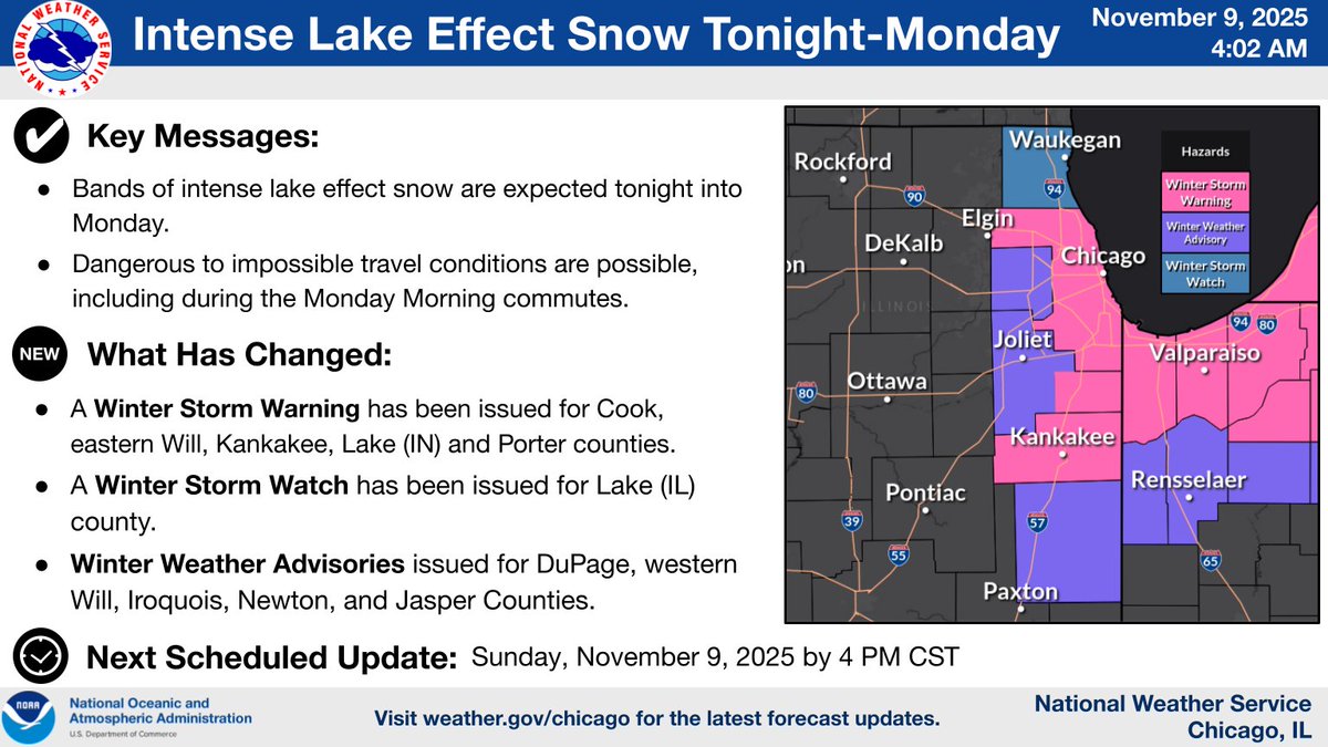
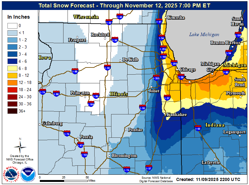
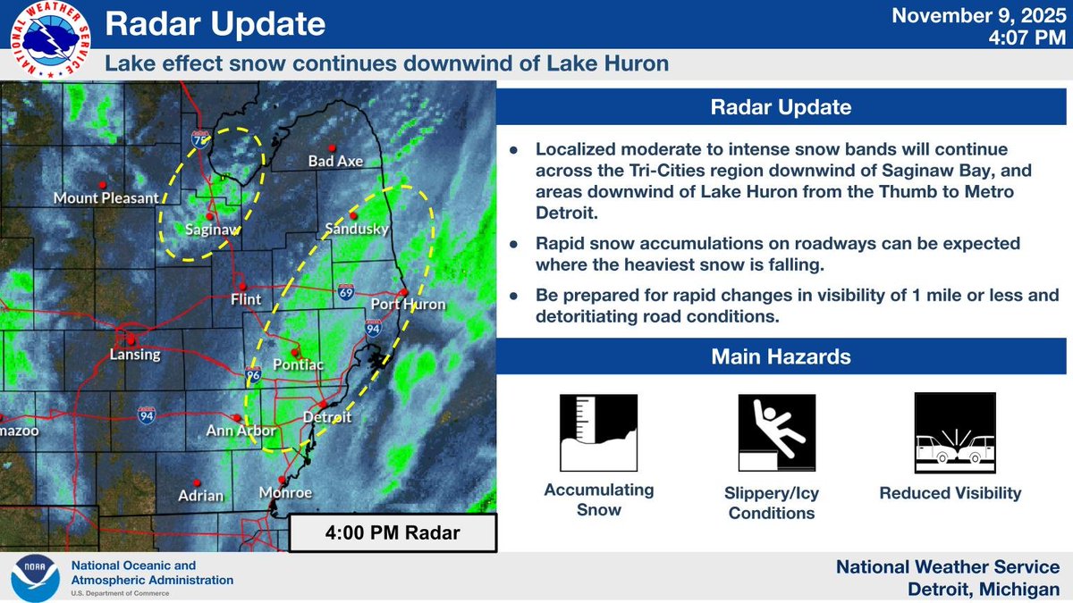
❄️ School Closing/Delay Odds for Mon Nov 10, 2025 Focused lake-effect tonight. Highest risk near the far SW lakeshore. Inland and SE Lower MI see light snow and slick spots. Odds use NWS alerts and probabilistic snow/ice for the morning commute.
English
1
0
1
1.4K