EDJ 🇵🇷

4.2K posts

EDJ 🇵🇷

EDJ 🇵🇷

@edj_25

🇵🇷

Bayamón, Puerto Rico Katılım Ağustos 2011
2.3K Takip Edilen92 Takipçiler
EDJ 🇵🇷 retweetledi
DTOP
DTOP@DTOP·
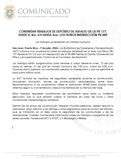
Trabajos asfalto en la Ave. Los Filtros, PR177 desde el Km 0.0 con la intersección de la PR-889 Frente al Centro Comercial Los Filtros y el supermercado Costco en @ciudadebayamon Desde el lunes, 13 hasta el viernes, 31 de julio de 7PM hasta las 5AM. @gobiernodepr @actprgov
DTOP tweet media
Español
0
2
3
1.1K
Roku Support
Roku Support@RokuSupport·
@edj_25 Hey there! You shouldn't miss out on your favorite episodes of Safe Space Season 2. Thanks for the details and for updating the app. For missing content, you can reach out to Tubi directly since they own the rights to the program.
English
1
0
0
18
EDJ 🇵🇷
EDJ 🇵🇷@edj_25·
@Tubi I have @Roku I don't see Season 2 of Safe Space by @KevOnStage. I ONLY see Season 1. I click All Episodes theres only 1 Season. The tubi Version is 3.10.38 I've click Update Tubi app on Roku and still not there. @RokuSupport Obviously don't know if its roku or tubi problem
English
1
0
0
53
EDJ 🇵🇷 retweetledi
Michael Lowry
Michael Lowry@MichaelRLowry·
In today's newsletter, I discuss where we might expect to see tropical development for the first half of June. Long range models are mostly mum for now, but we'll see if a weaker MJO pulse changes that tune by mid month. More ⬇️ michaelrlowry.substack.com/p/where-could-…
Michael Lowry tweet media
English
0
4
8
2.4K
EDJ 🇵🇷 retweetledi
Dr. Levi Cowan
Dr. Levi Cowan@TropicalTidbits·
🌀 The NOAA hurricane season outlook favors a below-average level of storm activity in the Atlantic this year, very sensible given developing El Niño conditions, which are generally hostile to Atlantic hurricanes. That said, it's important to be prepared with a hurricane plan each and every year; it's impossible to predict what land areas will get struck, and the overall level of expected storm activity doesn't provide assurances about the number of hurricane landfalls that will occur. Be smart and stay safe this season!
Dr. Levi Cowan tweet media
English
0
11
82
8K
Comunicaciones AAA
Comunicaciones AAA@AcueductosPR·
⚡️[Atención] La estación de bombas Carrizales en #Hatillo se encuentra fuera de operación por falla en el servicio eléctrico. ✍🏼 Se notifica a @lumaenergypr. 💧Clientes en Carrizales y comunidades aledañas experimentan interrupción del servicio de agua potable, mientras se corrige la falla.
Comunicaciones AAA tweet media
Español
1
0
1
438
NWS San Juan
NWS San Juan@NWSSanJuan·
[December 9th] 🌊⚠️ Low to Moderate Rip Current Risk today, increasing by Wednesday. Stay aware and swim near lifeguards. 🏊‍♂️ | Riesgo de Corrientes Marinas de Bajo a Moderado hoy, aumentando para el miércoles. Mantente alerta y nada cerca de salvavidas. #prwx #usviwx
NWS San Juan tweet media
Español
1
3
7
930
EDJ 🇵🇷 retweetledi
Noticias de Bayamón
Noticias de Bayamón@BayamonNews·
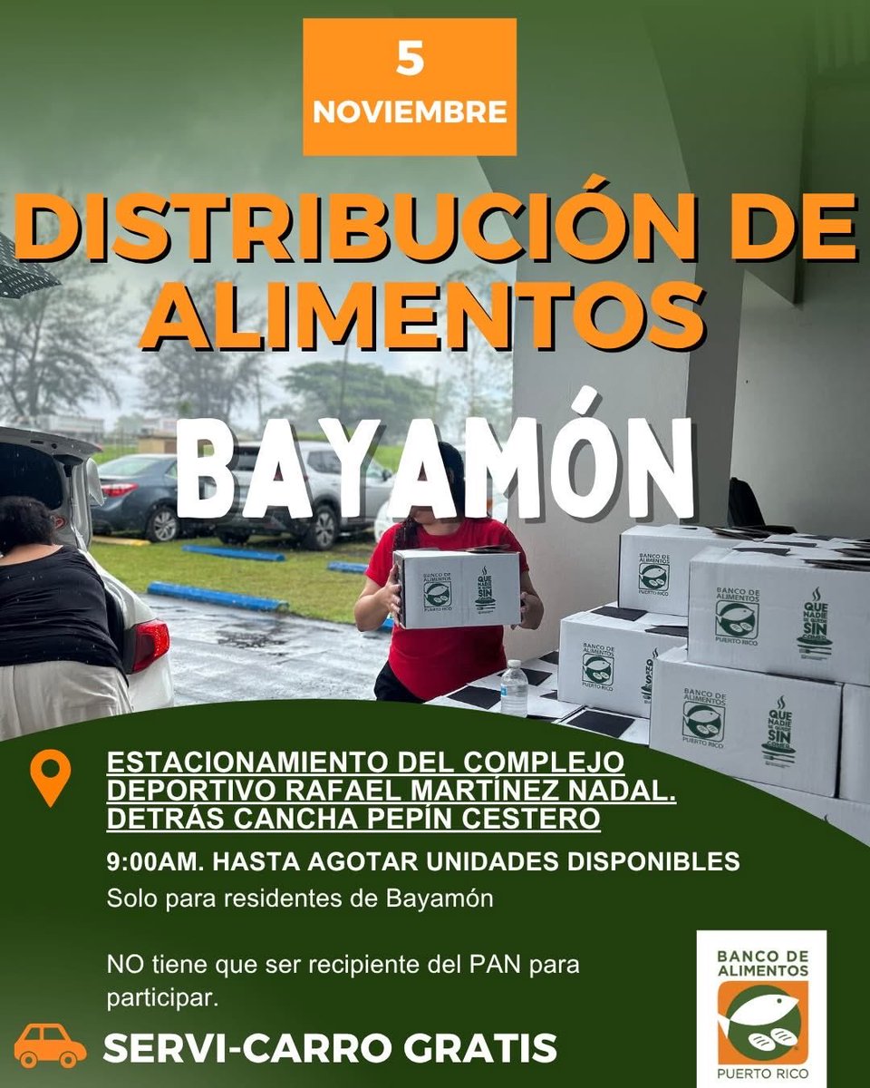
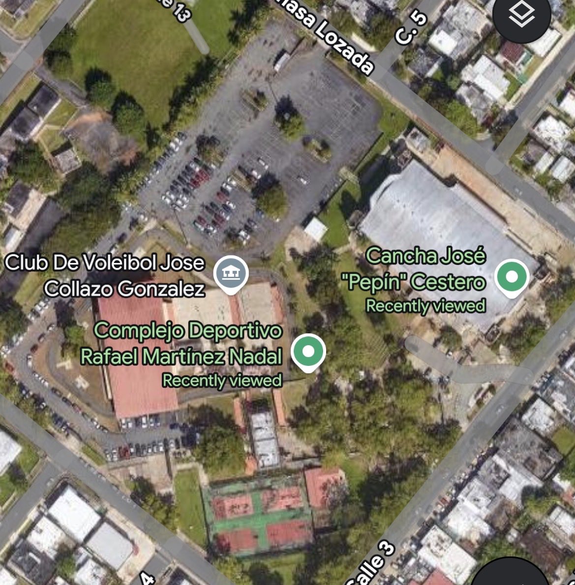
El Banco de Alimentos Puerto Rico anuncia distribución de alimentos para residentes de Bayamón. La distribución abierta para todos los bayamoneses, será el 5 de noviembre de 2025 a las 9am en el estacionamiento de la cancha Rafael Martínez Nadal (detrás de la Pepin Cestero)
Noticias de Bayamón tweet mediaNoticias de Bayamón tweet media
Español
0
2
1
136
EDJ 🇵🇷 retweetledi
MyRadar Weather
MyRadar Weather@MyRadarWX·
TROPICAL UPDATE: Invest 98L is now likely to develop into Melissa in the next several days. It could become a hurricane. Water temperatures in the Caribbean area between 86 and 89 degrees. That's high-octane fuel to allow a storm to strengthen. At present, our disturbance has thunderstorms, but not a cohesive center of circulation. That said, it will likely organize one by early Tuesday. Between Tuesday and Thursday, the storm will strengthen, perhaps quickly. The rate of strengthening will be key to its path. It could stay weak and continue drifting westward toward Central America. The MOST likely scenario, however, is a swifter intensification, perhaps into a Category 2 hurricane, as the system curves northeast toward Hispaniola or through the Mona Passage west of Puerto Rico. While PR would be spared the worst of the wind, that could set the island up for heavy rainfall and perhaps some flooding. There is a LOT to iron out with the system, particularly since the center hasn't even formed yet. Impacts won't begin until late Thursday at the earliest. Check back for frequent updates.
MyRadar Weather tweet media
English
2
7
66
22.8K
EDJ 🇵🇷 retweetledi
MyRadar Weather
MyRadar Weather@MyRadarWX·
🌀A new tropical wave over the central Atlantic is favored to develop in the Caribbean. “Melissa” is the next name up. MyRadar meteorologist @MatthewCappucci has an early forecast preview.
English
2
2
24
2.6K
EDJ 🇵🇷
EDJ 🇵🇷@edj_25·
@lumaenergypr #Bayamon Urb Santa Juanita 10ma Sección detrás de la Farmacia Santa Teresita cerca de Econo Morales sin luz 8:30pm
Español
0
0
1
249
Peacock
Peacock@peacock·
Scarlett Johansson, Jonathan Bailey, and Mahershala Ali? Say less. #JurassicWorldRebirth arrives October 30 on Peacock.
English
9
61
277
20.6K
EDJ 🇵🇷 retweetledi
Craig Setzer, CCM
Craig Setzer, CCM@CraigSetzer·
While Gabrielle turns north & east in the Atlantic, we turn our attention to a couple of features east of the islands. We'll keep an eye on both as we enter our second active period in this "start n' stop" hurricane season.
English
2
8
118
9.1K