Sabitlenmiş Tweet

Dr. Joseph Robinette, DDS
33.8K posts
@DrJoeRobinette
No one cares what this says.

STORM SURGE WATCH has been issued from the Mouth of the Mississippi River to the Alabama/Florida border. #Bertha

STORM SURGE WATCH has been issued from the Mouth of the Mississippi River to the Alabama/Florida border. #Bertha
The biggest threat from Invest 91L will likely be heavy rainfall across portions of the Northern Gulf Coast: 🌧️ Bands of tropical moisture could bring several inches of rain from the Florida Panhandle into parts of Alabama, Mississippi, & Louisiana through midweek. #flwx @wsvn
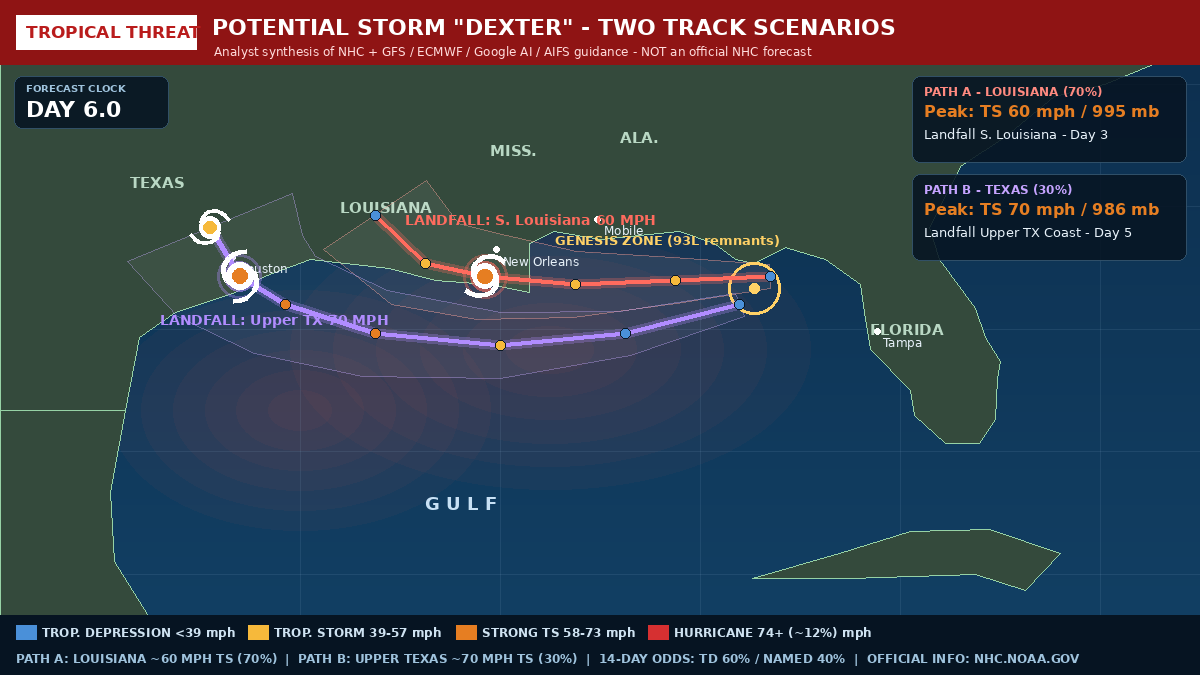
We used AI to combine the 4 major weather models (Google AI, GFS, ECMWF, European AI) of this potential storm developing in the Gulf of America. The analysis predicted- - Tropical Depression odds: 55% - Tropical named storm odds: 40% - Hurricane: 10% With 2 paths- A) Louisiana: 70% B) Texas: 30% This system will impact Florida if it forms as well. Keep an eye out this week for more information.


This storm is going to hit the Florida panhandle QUICKLY! Prepare right now if you’re in Pensacola, Destin, Panama City, Apalachia, and even Tallahassee. Florida will see impacts late tonight into Monday and Tuesday. 40-50 MPH gusts and 4 to 8 inches of rain. @GovRonDeSantis @FLSERT @KevinGuthrieFL

This storm is going to hit the Florida panhandle QUICKLY! Prepare right now if you’re in Pensacola, Destin, Panama City, Apalachia, and even Tallahassee. Florida will see impacts late tonight into Monday and Tuesday. 40-50 MPH gusts and 4 to 8 inches of rain. @GovRonDeSantis @FLSERT @KevinGuthrieFL


We used AI to combine the 4 major weather models (Google AI, GFS, ECMWF, European AI) of this potential storm developing in the Gulf of America. The analysis predicted- - Tropical Depression odds: 55% - Tropical named storm odds: 40% - Hurricane: 10% With 2 paths- A) Louisiana: 70% B) Texas: 30% This system will impact Florida if it forms as well. Keep an eye out this week for more information.

@Jaxm53 We work directly with EOG; be quiet about things you don’t know about. Your petty politics have no place in Floridas storm communication and recovery.


@KickboxerEsq @Real_miss_Jodie @megforflorida Nope. If you did, you could easily search Meg reposting it now. You or someone personally made it with AI maybe. I confirmed. It’s not there now. 2019 posts don’t show as X.com. They show as Twitter see below. Per usual I bring receipts. Fake news ✅
🌀 Odds of Gulf Tropical or Subtropical development are going up! 🌀 This is the Euro AI model for next Sunday. It was the first to pick up the signal of low pressure forming on an old front. Other models are slowly catching on. This “close to home” location is exactly where we would expect development in a strong El Niño because it is far away from the crazy Caribbean shear. The image is of pressure anomalies. It’s FAR from a lock and candidly it may NOT happen. It’s early. Here’s what we don’t know: How strong, where it will track, how much rain, if the Bucs 🏈 will win in 2027. Here’s what we do know: it won’t snow. ❄️ #gulf #tropicalstorm #hurricaneseason #elnino

This storm is going to hit the Florida panhandle QUICKLY! Prepare right now if you’re in Pensacola, Destin, Panama City, Apalachia, and even Tallahassee. Florida will see impacts late tonight into Monday and Tuesday. 40-50 MPH gusts and 4 to 8 inches of rain. @GovRonDeSantis @FLSERT @KevinGuthrieFL