Amir

3.5K posts

Amir banner
Amir

Amir

@x4rius

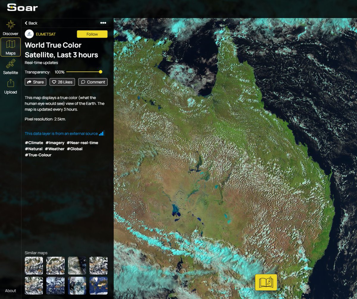
Just having a fair dinkum go at life 🌴 🇦🇺 Doing lots of cool stuff at @soaratlas, Detail and IREX (👽)

San Francisco, CA Katılım Temmuz 2017
1.1K Takip Edilen1K Takipçiler
Joe Morrison
Joe Morrison@mouthofmorrison·
@fikocian @Ju11am We’ve been buddies since we met at Space Symposium and he told me my mean tweets helped him fundraise
English
2
0
30
697
Amir
Amir@x4rius·
Lots of bullshit out there about nuking Tehran Iran. Take a deep breath & actually think of the implications - on EVERYTHING. An aerial image of the aftermath of the Hiroshima atomic attack tinyurl.com/33n57ae3 It should make us all come to the same conclusion = Never again.
Amir tweet media
English
0
0
1
41
Amir
Amir@x4rius·
@SoarAtlas Its a solar power farm in Ne'ot Hovav reflecting sunlight as the NASA bird flew over and took a photo this morning ☀️
Amir tweet media
English
0
0
2
34
Amir
Amir@x4rius·
Was just checking out my Daily NASA World True Color feed on @SoarAtlas as I do every morning and noticed this over southern Israel. What an odd cloud? Atomic mushroom? UFO? Zoomed in turns out its... (answer in reply) 🤯
Amir tweet media
English
1
0
2
74
Amir
Amir@x4rius·
@SoarAtlas Looks like things are blowing up 😆
English
0
0
0
28
Soar
Soar@SoarAtlas·
Satellite imagery from Mar 30th shows a large dust storm making its way across northwest Africa measuring more than 1200km long. Explore & compare here: tinyurl.com/45xp4wn9
English
1
0
23
3.6K
Joe Morrison
Joe Morrison@mouthofmorrison·
This is how Philip and I met
Joe Morrison tweet media
Philip Johnston@PhilipJohnston

I am super excited to share that @Starcloud_ has raised a $170M Series A at a $1.1bn valuation to fuel our development of data centers in space 🚀 The round comes after the successful deployment of our first satellite, Starcould-1, a few months ago, which had the first @NVIDIA H100 on board and was the first to train an LLM in space. The funds will be used to develop our third satellite, which aims to be cost-competitive with Earth-based data centers in terms of AI inference cost. The round was led by @Benchmark and @EQT Ventures, and we are excited to welcome Benchmark GP, @Chetanp Puttagunta, to our board. We are also excited to welcome other new investors, including the world's largest infrastructure fund, @Macquarie Capital, @SevenSevenSix 7️⃣7️⃣6️⃣, Manhattan West, Adjacent, Carya, GSBackers, and Harpoon. We are very grateful for the continued support of existing investors, including @NFX@NebularVC@YCombinator@FUSE_VC@Soma_Capital, 3Capital Partners, Wyld VC, Tiny VC, and Taurus Ventures. Onwards!

English
5
1
80
14.6K
Amir retweetledi
Soar
Soar@SoarAtlas·
🔥UPDATE: Satellite imagery confirms smoke over Al Azeezah originates from unusual activity of flare stacks at the ASAB Central Degassing Station. Despite speculation of a strike, no visible damage is present. Explore & compare here: tinyurl.com/hr8sny5j #UAE #MiddleEast
English
2
9
62
12K
Mario Nawfal
Mario Nawfal@MarioNawfal·
🇮🇷🇺🇸🇮🇱 Aftermath footage shows U.S. Israeli strikes hitting Iran’s water lifeline. A 10,000 m³ reservoir wiped out in Haftkel. Tehran’s water agency wrecked. With shortages already at 60 year lows, civilians are getting hit even harder.
Mario Nawfal@MarioNawfal

🚨🇮🇷 A man and his dog fleeing bombs in Tehran. The city was struck ten times more intensely in the last 24 hours than before, according to a resident. @DropSiteNews

English
62
103
234
412.5K
Amir retweetledi
Soar
Soar@SoarAtlas·
Many people have asked why satellite imagery showing damage in Israel isn’t available on our platform. This is primarily due to limitations in the available satellite data, along with current restrictions in place during this conflict. Large-scale damage in Iran is often visible in freely available satellite imagery due to its scale, for example, impacts on airbases, industrial facilities, or extensive smoke plumes. In contrast, impacts in Israel have been reported to be typically smaller and more localized, often affecting individual buildings or streets, which usually fall below the resolution of free satellites which we use such as Sentinel and Landsat. Open source satellite imagery collected by the likes of the European Space Agency and NASA have a coarser resolution compared to commercial imagery providers including Airbus, Planet, and Vantor. This means much of the damage can be difficult to detect unless it occurs at a larger scale, for example, smoke from airstrikes can be clearly visible from space over long distances, whereas smaller incidents may not appear in freely available imagery. Detecting this level of detail requires high-resolution commercial imagery, which is currently restricted or delayed by major providers in this area during the conflict, something that is unfortunately beyond our control. In saying this, we highly encourage anyone to explore and investigate areas of interest using the free tools available on Soar Atlas. We’re also always open to community suggestions. Our community has done some incredible investigations and we hope our tools help make those findings easier to share. We do not take sides. Soar Atlas exists to make satellite imagery and mapping a more transparent, accountable, and a trusted source of information for everyone. We continue to hope for peace for all 🕊
English
16
27
258
110.7K
Amir retweetledi
Soar
Soar@SoarAtlas·
Satellites are in the power of everyones hands now, with free imagery easily accessible from a PC or Phone. Here's how you can investigate our planet in just a few clicks: soaratlas.com/satellites Now more than ever, tools like these help us understand what's happening.
English
1
13
103
9.2K
Tomthunkit™
Tomthunkit™@TomthunkitsMind·
The War Soup just got thicker. RUSSIA GAVE IRAN FOUR S-400 AIR DEFENSE SYSTEM BATTALIONS. Now, every $100 million, Israeli & US F-35 Stealth Bomber Jet can be tracked in real time. They’re no longer invisible. These complete S-400 battalions come with 8 launchers, each with 4 missile canisters, and 512 assorted missile types.
English
219
1.6K
4K
247.7K
Amir
Amir@x4rius·
@MT_Anderson @EpicFuryMap @vcdgf555 Thanks for this post MT 👏 At @SoarAtlas we are experimenting with turning any 2D map into 3D for interactive fly throughs and annotations. I was wondering what the Eagle 44 air base was looking like these days. Is your image available in GeoTIFF format?
Amir tweet media
English
0
0
1
66
MT Anderson
MT Anderson@MT_Anderson·
Following up on this 👇 Mar 14 imagery of the Oghab 44 (120 km NW of Bandar Abbas) underground airbase (28.046, 55.520) shows several potential impact points on the hillside above the tunnel entrances. Without recent baseline imagery to compare against, I'm holding off on an assessment. Are we looking at fresh munition impacts or pre-existing construction/terrain anomalies? Source: Powered by @Satellogic Delivered by @SkyfiApp Date: 14 March 2026 @LatinMilAv
MT Anderson tweet media
Latin American Military Aviation@LatinMilAv

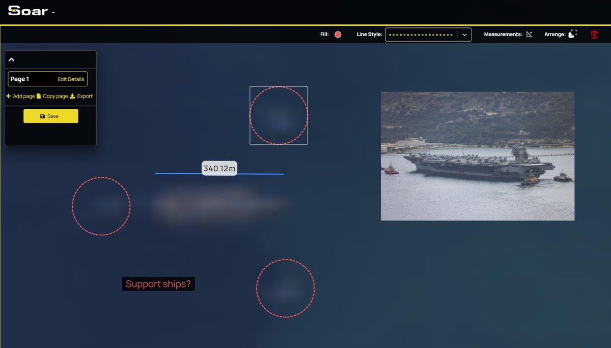
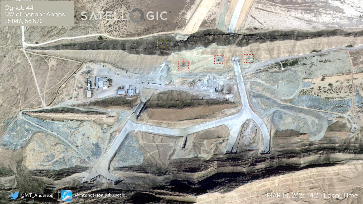
Almost a month into the air campaign against Iran and no indication Oghab 44, the #IRIAF underground facility NW of Bandar Abbas, has been targeted - this is interesting and worth considering 1/

English
8
39
201
63.5K
Amir retweetledi
Soar
Soar@SoarAtlas·
🌧Australia is rapidly greening after intense summer rains. See for yourself: tinyurl.com/3jyj5umk Satellite data shows vegetation surging as some regions received months’ worth of rainfall in days, triggering widespread plant growth across normally arid areas.
Soar tweet media
English
3
1
19
7.2K
Amir
Amir@x4rius·
PAN (black and white) 10m per pixel imagery over Kharg Island, Iran before the war began Feb 25 and today Mar 22 showing no change detection? Can anyone else spot differences? Latest image here: soaratlas.com/satellites?pos…
GIF
English
1
4
16
1.7K