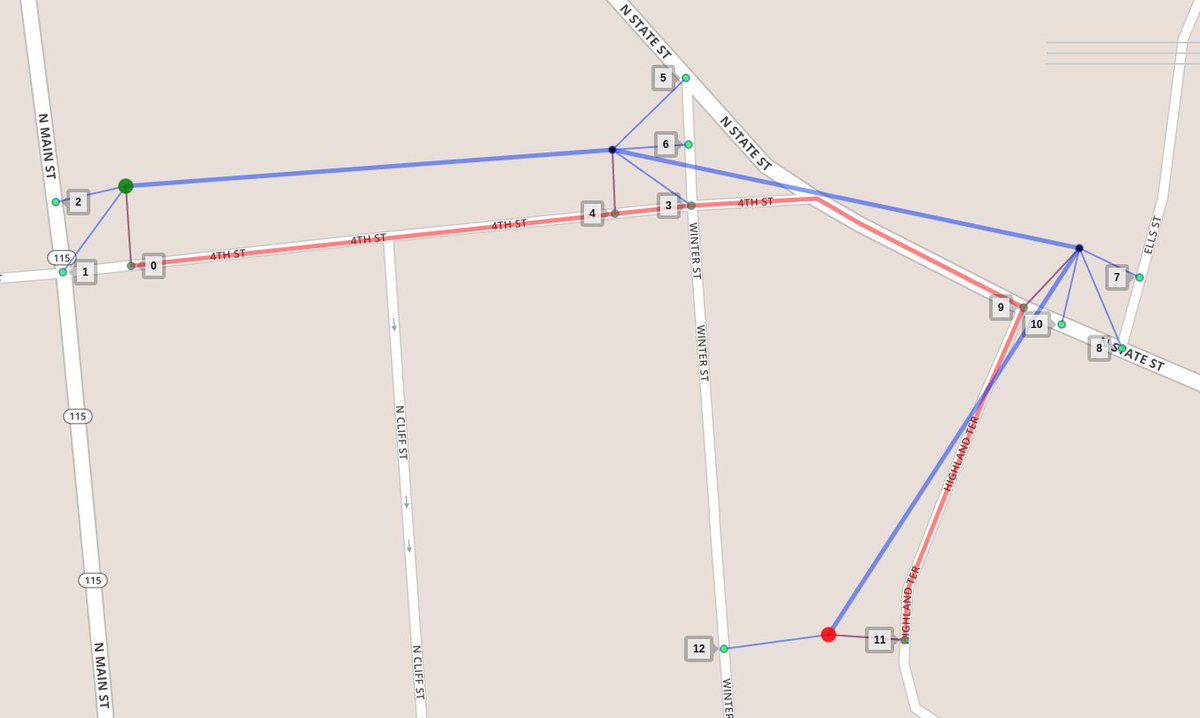
GIS • OPS . SԀO • SI⅁

583 posts

GIS • OPS . SԀO • SI⅁ banner
GIS • OPS . SԀO • SI⅁

GIS • OPS . SԀO • SI⅁

@gis_ops

Experts on FOSS routing & navigation solutions ••• openstreetmap ••• web-(m)apps ••• QGIS ••• PostGIS ••• Follow us for insights in geospatial FOSS! 🌏🌍🌎

Berlin, Germany Katılım Ocak 2019
403 Takip Edilen346 Takipçiler
GIS • OPS . SԀO • SI⅁
@Dr_NicEllis @pokateo_ The latter won’t give you access in the UI via the Processing toolbox though. It’d be pretty easy to write a wrapper for that. That kind of wrapper could even be very generic, just converting QGIS input to ESRI input. Sounds like a pretty worthy weekend project:)
English
0
0
1
0
GIS • OPS . SԀO • SI⅁
@Dr_NicEllis @pokateo_ Without depending on ArcGIS anymore, you’d have to re-write all portions using arcpy with pyqgis. If you can depend on ArcGIS, you just have to patch QGIS‘ PYTHONPATH to include the directory of arcpy.
English
1
0
1
0
GIS • OPS . SԀO • SI⅁
@SteveC There’s some strong small-kid-that’s-my-toy vibes. Couldn’t agree less with almost everything. And instead of weirdly insulting all Germans, you might wanna dig into its culture a little by learning some, e.g. beleidigte Leberwurst and Fremdschämen come to mind
English
0
0
0
0
GIS • OPS . SԀO • SI⅁ retweetledi
Geo_Spatialist
Geo_Spatialist@geo_spatialist·
@vintagemapstore This is a render of mine if you would like to credit me.
English
2
6
206
0
GIS • OPS . SԀO • SI⅁ retweetledi
Brent Toderian
Brent Toderian@BrentToderian·
A typical European car is parked 92% of the time. It spends 1/5th of its driving time looking for parking. Its 5 seats only move 1.5 people. 86% of its fuel never reaches the wheels, & most of the energy that does, moves the car, not people. Seems important. HT @circulareconomy
Brent Toderian tweet media
English
34
714
2K
0
Danny Coutts
Danny Coutts@ActiveMargins·
I'm close to writing a recommendation that @QGIS is the superior solution for handling geospatial data and cartography work. Anyone have experience converting an organization from ESRI ecosystem to @QGIS? From numerous File Geodatabases to possibly a PostGIS server? #gischat
English
18
22
149
0
GIS • OPS . SԀO • SI⅁ retweetledi
Ujaval Gandhi
Ujaval Gandhi@spatialthoughts·
New Tutorial: Calculating Raster Area in #QGIS A step-by-step guide on quantifying land-use within a region using QGIS Processing Tools using the amazing ESA WorldCover dataset. qgistutorials.com/en/docs/3/calc…
Ujaval Gandhi tweet media
English
5
97
326
0
Kyle Walker
Kyle Walker@kyle_e_walker·
The @Mapbox Isochrone API now incorporates live and historical traffic, and these updates are available to #rstats users in the mapboxapi package (new version just submitted to CRAN). Also check out the new ggplot2 basemap functionality thanks to @elipousson's contributions!
Kyle Walker tweet mediaKyle Walker tweet media
English
2
19
152
0